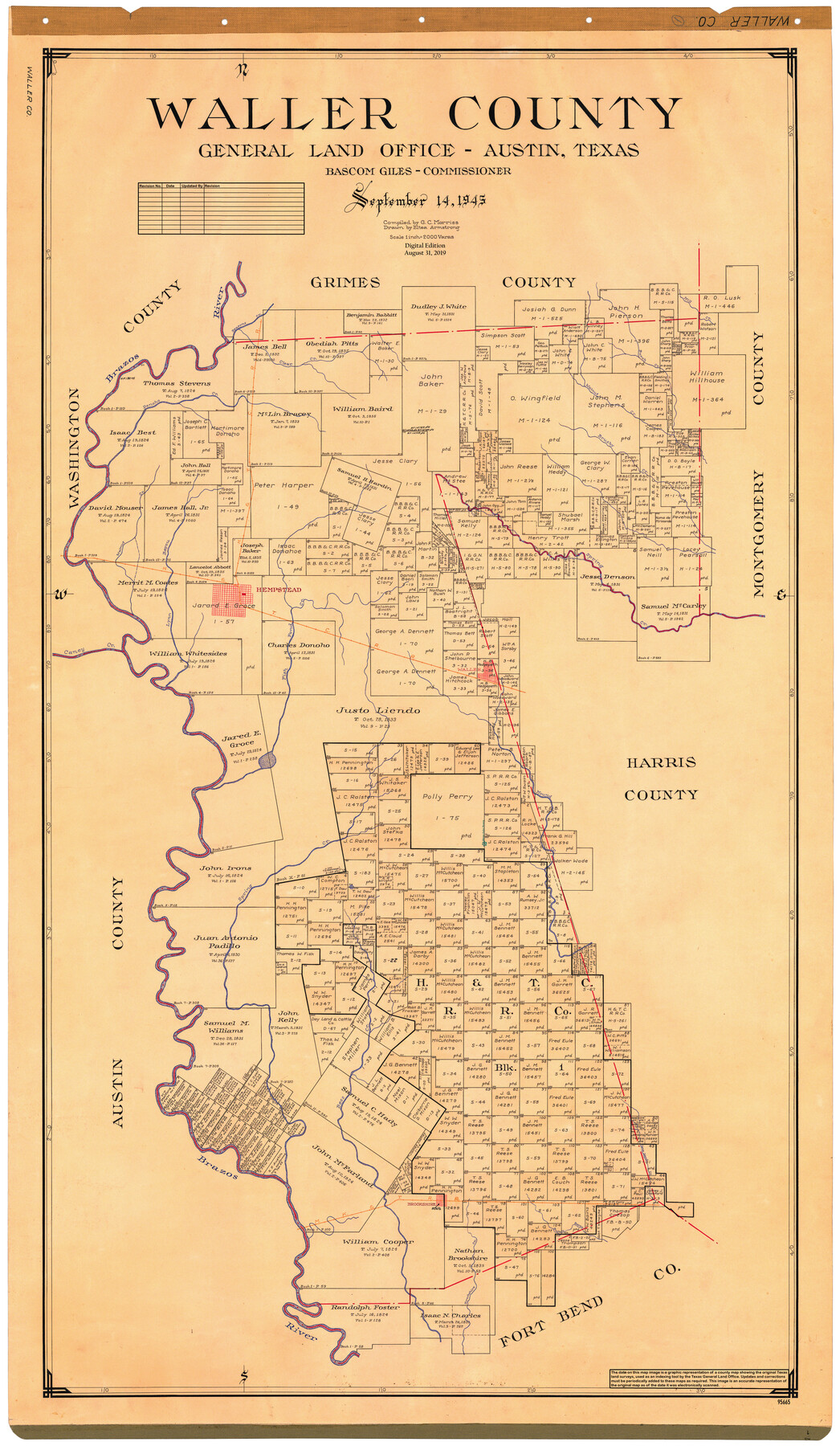
Waller County
General Land Office Official County Map
-
Map/Doc
95665
-
Collection
General Map Collection
-
Object Dates
2019/8/31 (Revision Date)
1945/9/14 (Creation Date)
-
People and Organizations
Cheyenne Betancourt (Draftsman)
Eltea Armstrong (Draftsman)
G.C. Morriss (Compiler)
Bascom Giles (GLO Commissioner)
-
Counties
Waller
-
Subjects
County OCM
-
Height x Width
48.9 x 28.4 inches
124.2 x 72.1 cm
-
Medium
digital image
-
Scale
1" = 2000 varas
Part of: General Map Collection
Bowie County Working Sketch 6

Print $20.00
- Digital $50.00
Bowie County Working Sketch 6
1928
Size 27.4 x 22.9 inches
Map/Doc 67410
Flight Mission No. CGI-1N, Frame 137, Cameron County

Print $20.00
- Digital $50.00
Flight Mission No. CGI-1N, Frame 137, Cameron County
1955
Size 15.5 x 18.8 inches
Map/Doc 84493
Louisiana and Texas Intracoastal Waterway Proposed Extension to Rio Grande Valley

Print $20.00
- Digital $50.00
Louisiana and Texas Intracoastal Waterway Proposed Extension to Rio Grande Valley
1941
Size 28.4 x 41.3 inches
Map/Doc 61890
[Surveys in McMullen and McGloin's Colony along the San Antonio River]
![30, [Surveys in McMullen and McGloin's Colony along the San Antonio River], General Map Collection](https://historictexasmaps.com/wmedia_w700/maps/30-1.tif.jpg)
Print $20.00
- Digital $50.00
[Surveys in McMullen and McGloin's Colony along the San Antonio River]
1828
Size 19.3 x 24.5 inches
Map/Doc 30
Menard County Sketch File 9

Print $4.00
- Digital $50.00
Menard County Sketch File 9
Size 10.7 x 8.2 inches
Map/Doc 31494
Nueces County Rolled Sketch 69

Print $20.00
- Digital $50.00
Nueces County Rolled Sketch 69
Size 23.8 x 33.0 inches
Map/Doc 6920
Duval County Boundary File 3l

Print $40.00
- Digital $50.00
Duval County Boundary File 3l
Size 13.4 x 17.1 inches
Map/Doc 52761

Flight Mission No. DCL-6C, Frame 133, Kenedy County

Print $20.00
- Digital $50.00
Flight Mission No. DCL-6C, Frame 133, Kenedy County
1943
Size 18.6 x 22.3 inches
Map/Doc 85963
Refugio County Sketch File 5

Print $8.00
- Digital $50.00
Refugio County Sketch File 5
1849
Size 12.8 x 8.3 inches
Map/Doc 35245
Throckmorton County Sketch File 5a

Print $22.00
- Digital $50.00
Throckmorton County Sketch File 5a
Size 8.0 x 7.8 inches
Map/Doc 38075
Township No. 5 South Range No. 11 West of the Indian Meridian

Print $20.00
- Digital $50.00
Township No. 5 South Range No. 11 West of the Indian Meridian
1875
Size 19.3 x 24.3 inches
Map/Doc 75160
You may also like
Bell County Working Sketch 6

Print $20.00
- Digital $50.00
Bell County Working Sketch 6
1946
Size 24.9 x 33.6 inches
Map/Doc 67346
Van Zandt County Sketch File 47

Print $7.00
- Digital $50.00
Van Zandt County Sketch File 47
Size 10.0 x 8.1 inches
Map/Doc 39504
Bell County Working Sketch 2

Print $20.00
- Digital $50.00
Bell County Working Sketch 2
1938
Size 25.8 x 28.8 inches
Map/Doc 67342
Flight Mission No. CRC-3R, Frame 10, Chambers County

Print $20.00
- Digital $50.00
Flight Mission No. CRC-3R, Frame 10, Chambers County
1956
Size 18.5 x 22.2 inches
Map/Doc 84784
Flight Mission No. CUG-1P, Frame 21, Kleberg County

Print $20.00
- Digital $50.00
Flight Mission No. CUG-1P, Frame 21, Kleberg County
1956
Size 18.5 x 22.2 inches
Map/Doc 86111
Duval County Rolled Sketch 38

Print $20.00
- Digital $50.00
Duval County Rolled Sketch 38
1937
Size 22.6 x 16.1 inches
Map/Doc 5755
Duval County Rolled Sketch 40

Print $20.00
- Digital $50.00
Duval County Rolled Sketch 40
1958
Size 22.8 x 31.1 inches
Map/Doc 5757
Culberson County Sketch File 17

Print $10.00
- Digital $50.00
Culberson County Sketch File 17
1932
Size 11.2 x 8.8 inches
Map/Doc 20180

Bailey County Sketch File 9

Print $40.00
- Digital $50.00
Bailey County Sketch File 9
Size 22.4 x 18.1 inches
Map/Doc 10885
Wichita County Sketch File E

Print $40.00
- Digital $50.00
Wichita County Sketch File E
Size 14.2 x 15.6 inches
Map/Doc 40072
San Patricio County Sketch File 35

Print $16.00
- Digital $50.00
San Patricio County Sketch File 35
1917
Size 14.5 x 8.8 inches
Map/Doc 36121