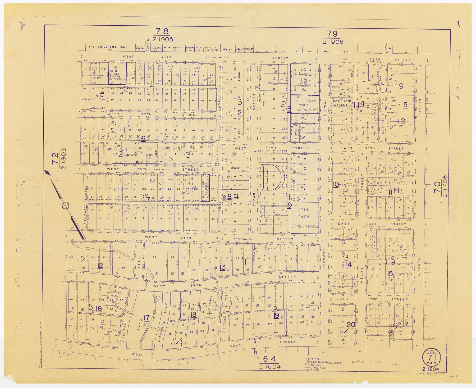
Travis County Appraisal District Plat Map 2_1804
Section 71
-
Map/Doc
94203
-
Collection
General Map Collection
-
Object Dates
1953 (Copy/Tracing Date)
1985 (Edition Date)
-
People and Organizations
Travis County Appraisal District (Publisher)
D. Redburn (Tracer)
-
Counties
Travis
-
Subjects
City
-
Height x Width
21.6 x 26.5 inches
54.9 x 67.3 cm
-
Medium
blueprint/diazo
-
Scale
1" = 100'
Part of: General Map Collection
Aransas Pass to Baffin Bay

Print $20.00
- Digital $50.00
Aransas Pass to Baffin Bay
1961
Size 42.1 x 35.4 inches
Map/Doc 73414

Bastrop County Sketch File 13

Print $6.00
- Digital $50.00
Bastrop County Sketch File 13
1845
Size 10.1 x 15.8 inches
Map/Doc 14070
Reagan County Working Sketch 46b

Print $20.00
- Digital $50.00
Reagan County Working Sketch 46b
1987
Size 31.4 x 45.2 inches
Map/Doc 71889
Calhoun County Sketch File 9

Print $14.00
- Digital $50.00
Calhoun County Sketch File 9
1953
Size 11.5 x 14.0 inches
Map/Doc 35936
Flight Mission No. DIX-10P, Frame 178, Aransas County

Print $20.00
- Digital $50.00
Flight Mission No. DIX-10P, Frame 178, Aransas County
1956
Size 18.5 x 22.2 inches
Map/Doc 83968
Mills County Sketch File 23

Print $4.00
- Digital $50.00
Mills County Sketch File 23
Size 12.4 x 9.2 inches
Map/Doc 31672
[Sketch for Mineral Applications 26885-6 - Reagan and Crockett Cos., W. H. Bland]
![3219, [Sketch for Mineral Applications 26885-6 - Reagan and Crockett Cos., W. H. Bland], General Map Collection](https://historictexasmaps.com/wmedia_w700/maps/3219-1.tif.jpg)
Print $20.00
- Digital $50.00
[Sketch for Mineral Applications 26885-6 - Reagan and Crockett Cos., W. H. Bland]
1932
Size 38.4 x 9.7 inches
Map/Doc 3219
Motley County Sketch File 22 (N)

Print $34.00
- Digital $50.00
Motley County Sketch File 22 (N)
1887
Size 8.2 x 8.4 inches
Map/Doc 32069
Map of Upshur County Texas

Print $20.00
- Digital $50.00
Map of Upshur County Texas
1873
Size 20.4 x 15.2 inches
Map/Doc 4635
Engineer's Office, Department of the Gulf Map No. 59, Texas prepared by order of Maj. Gen. N. P. Banks under direction of Capt. P. C. Hains, U. S. Engr. & Chief Engr., Dept. of the Gulf

Print $20.00
- Digital $50.00
Engineer's Office, Department of the Gulf Map No. 59, Texas prepared by order of Maj. Gen. N. P. Banks under direction of Capt. P. C. Hains, U. S. Engr. & Chief Engr., Dept. of the Gulf
1865
Size 18.2 x 27.5 inches
Map/Doc 72716
Nueces County Rolled Sketch 50

Print $20.00
- Digital $50.00
Nueces County Rolled Sketch 50
1939
Size 21.9 x 38.0 inches
Map/Doc 9605
You may also like
Gray County Rolled Sketch A

Print $20.00
- Digital $50.00
Gray County Rolled Sketch A
1888
Size 40.4 x 40.8 inches
Map/Doc 9008
Montague County Working Sketch 3

Print $20.00
- Digital $50.00
Montague County Working Sketch 3
1912
Size 20.5 x 15.4 inches
Map/Doc 71069
Flight Mission No. DIX-5P, Frame 143, Aransas County

Print $20.00
- Digital $50.00
Flight Mission No. DIX-5P, Frame 143, Aransas County
1956
Size 17.0 x 17.1 inches
Map/Doc 83804
[Southwest corner of county covering Blks. 24 and B9]
![90489, [Southwest corner of county covering Blks. 24 and B9], Twichell Survey Records](https://historictexasmaps.com/wmedia_w700/maps/90489-1.tif.jpg)
Print $20.00
- Digital $50.00
[Southwest corner of county covering Blks. 24 and B9]
1905
Size 16.7 x 13.9 inches
Map/Doc 90489
Dickens County Rolled Sketch P1

Print $20.00
- Digital $50.00
Dickens County Rolled Sketch P1
1915
Size 40.5 x 36.2 inches
Map/Doc 8783
Nolan County Rolled Sketch 2

Print $20.00
- Digital $50.00
Nolan County Rolled Sketch 2
1956
Size 27.7 x 35.0 inches
Map/Doc 6860
Liberty County Working Sketch 1

Print $20.00
- Digital $50.00
Liberty County Working Sketch 1
Size 26.5 x 29.7 inches
Map/Doc 70460
Flight Mission No. DQO-2K, Frame 89, Galveston County

Print $20.00
- Digital $50.00
Flight Mission No. DQO-2K, Frame 89, Galveston County
1952
Size 18.6 x 22.3 inches
Map/Doc 85016
Brewster County Rolled Sketch 106

Print $20.00
- Digital $50.00
Brewster County Rolled Sketch 106
1958
Size 20.7 x 24.6 inches
Map/Doc 5258
Concho County Rolled Sketch 21

Print $20.00
- Digital $50.00
Concho County Rolled Sketch 21
1969
Size 38.3 x 43.5 inches
Map/Doc 8666
Map of east part of West Bay & SW part of Galveston Bay, Galveston County showing subdivision for mineral development

Print $40.00
- Digital $50.00
Map of east part of West Bay & SW part of Galveston Bay, Galveston County showing subdivision for mineral development
1963
Size 64.1 x 45.4 inches
Map/Doc 3079
Zavala County Sketch File 44

Print $25.00
- Digital $50.00
Zavala County Sketch File 44
1915
Size 10.1 x 14.3 inches
Map/Doc 41416