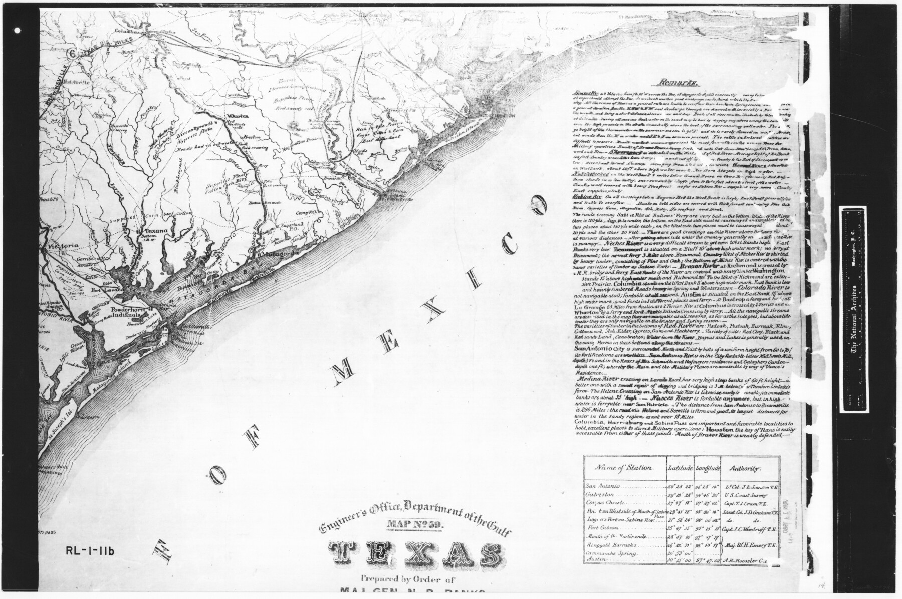
Engineer's Office, Department of the Gulf Map No. 59, Texas prepared by order of Maj. Gen. N. P. Banks under direction of Capt. P. C. Hains, U. S. Engr. & Chief Engr., Dept. of the Gulf
RL-1-11b
-
Map/Doc
72716
-
Collection
General Map Collection
-
Object Dates
1865 (Creation Date)
-
People and Organizations
W. Probert (Printer)
U. S. Coast Survey (Surveyor/Engineer)
A.R. Roessler (Author)
A.R. Roessler (Compiler)
A.R. Roessler (Draftsman)
-
Subjects
Gulf of Mexico State of Texas
-
Height x Width
18.2 x 27.5 inches
46.2 x 69.9 cm
-
Comments
B/W photostat copy from National Archives in multiple pieces.
Part of: General Map Collection
Bailey County

Print $40.00
- Digital $50.00
Bailey County
1956
Size 49.4 x 31.4 inches
Map/Doc 95423
Crockett County Working Sketch 56

Print $20.00
- Digital $50.00
Crockett County Working Sketch 56
1947
Size 28.5 x 46.7 inches
Map/Doc 68389
Upton County Rolled Sketch 2

Print $20.00
- Digital $50.00
Upton County Rolled Sketch 2
1884
Size 26.2 x 36.1 inches
Map/Doc 8065
Hudspeth County Rolled Sketch 55

Print $49.00
- Digital $50.00
Hudspeth County Rolled Sketch 55
1977
Size 10.0 x 15.0 inches
Map/Doc 45968
Sutton County Working Sketch 56

Print $20.00
- Digital $50.00
Sutton County Working Sketch 56
1958
Size 27.6 x 28.8 inches
Map/Doc 62399
The Military History of Texas Map!

The Military History of Texas Map!
Size 24.2 x 35.2 inches
Map/Doc 94359
Flight Mission No. CRC-2R, Frame 53, Chambers County

Print $20.00
- Digital $50.00
Flight Mission No. CRC-2R, Frame 53, Chambers County
1956
Size 18.5 x 22.4 inches
Map/Doc 84726
Right of Way and Track Map, the Missouri, Kansas & Texas Ry. Of Texas operated by the Missouri, Kansas & Texas Ry. Of Texas, Houston Division

Print $40.00
- Digital $50.00
Right of Way and Track Map, the Missouri, Kansas & Texas Ry. Of Texas operated by the Missouri, Kansas & Texas Ry. Of Texas, Houston Division
1918
Size 26.0 x 62.1 inches
Map/Doc 64785
Dallas County Working Sketch Graphic Index

Print $20.00
- Digital $50.00
Dallas County Working Sketch Graphic Index
1942
Size 43.9 x 36.7 inches
Map/Doc 76517
Wise County Sketch File 53

Print $12.00
- Digital $50.00
Wise County Sketch File 53
2007
Size 8.5 x 14.0 inches
Map/Doc 87360
[Surveys along the Colorado River]
![49, [Surveys along the Colorado River], General Map Collection](https://historictexasmaps.com/wmedia_w700/maps/49.tif.jpg)
Print $20.00
- Digital $50.00
[Surveys along the Colorado River]
Size 28.6 x 24.0 inches
Map/Doc 49
McCulloch County Sketch File 8

Print $4.00
- Digital $50.00
McCulloch County Sketch File 8
1904
Size 11.3 x 8.7 inches
Map/Doc 31182
You may also like
Flight Mission No. CGI-1N, Frame 171, Cameron County

Print $20.00
- Digital $50.00
Flight Mission No. CGI-1N, Frame 171, Cameron County
1955
Size 18.5 x 22.2 inches
Map/Doc 84506
University Lands Blocks 29-33, Crockett County, Texas

Print $20.00
- Digital $50.00
University Lands Blocks 29-33, Crockett County, Texas
1936
Size 29.8 x 42.7 inches
Map/Doc 2443
Borden County, Texas

Print $20.00
- Digital $50.00
Borden County, Texas
1887
Size 19.9 x 18.3 inches
Map/Doc 596
Flight Mission No. DQO-1K, Frame 40, Galveston County

Print $20.00
- Digital $50.00
Flight Mission No. DQO-1K, Frame 40, Galveston County
1952
Size 18.8 x 22.6 inches
Map/Doc 84983
Hunt County Rolled Sketch 5

Print $20.00
- Digital $50.00
Hunt County Rolled Sketch 5
1956
Size 22.9 x 23.0 inches
Map/Doc 6272
Presidio County Working Sketch 116

Print $20.00
- Digital $50.00
Presidio County Working Sketch 116
1982
Size 27.8 x 42.4 inches
Map/Doc 71793
Corpus Christi Harbor

Print $40.00
- Digital $50.00
Corpus Christi Harbor
1973
Size 37.8 x 51.9 inches
Map/Doc 73478
Montgomery County Rolled Sketch 20

Print $20.00
- Digital $50.00
Montgomery County Rolled Sketch 20
1933
Size 34.5 x 33.7 inches
Map/Doc 9531
Bandera County Rolled Sketch 5

Print $20.00
- Digital $50.00
Bandera County Rolled Sketch 5
1973
Size 19.8 x 31.0 inches
Map/Doc 5117
Map of the Mirror's Addition to the town of Amarillo, Potter County, Texas on the line of the Fort Worth and Denver City Ry.

Print $20.00
- Digital $50.00
Map of the Mirror's Addition to the town of Amarillo, Potter County, Texas on the line of the Fort Worth and Denver City Ry.
Size 13.3 x 20.1 inches
Map/Doc 91787
McLennan County Boundary File 4a

Print $8.00
- Digital $50.00
McLennan County Boundary File 4a
Size 14.1 x 8.6 inches
Map/Doc 56979
United States - Gulf Coast - Padre I. and Laguna Madre Lat. 27° 12' to Lat. 26° 33' Texas

Print $20.00
- Digital $50.00
United States - Gulf Coast - Padre I. and Laguna Madre Lat. 27° 12' to Lat. 26° 33' Texas
1913
Size 27.0 x 18.3 inches
Map/Doc 72819