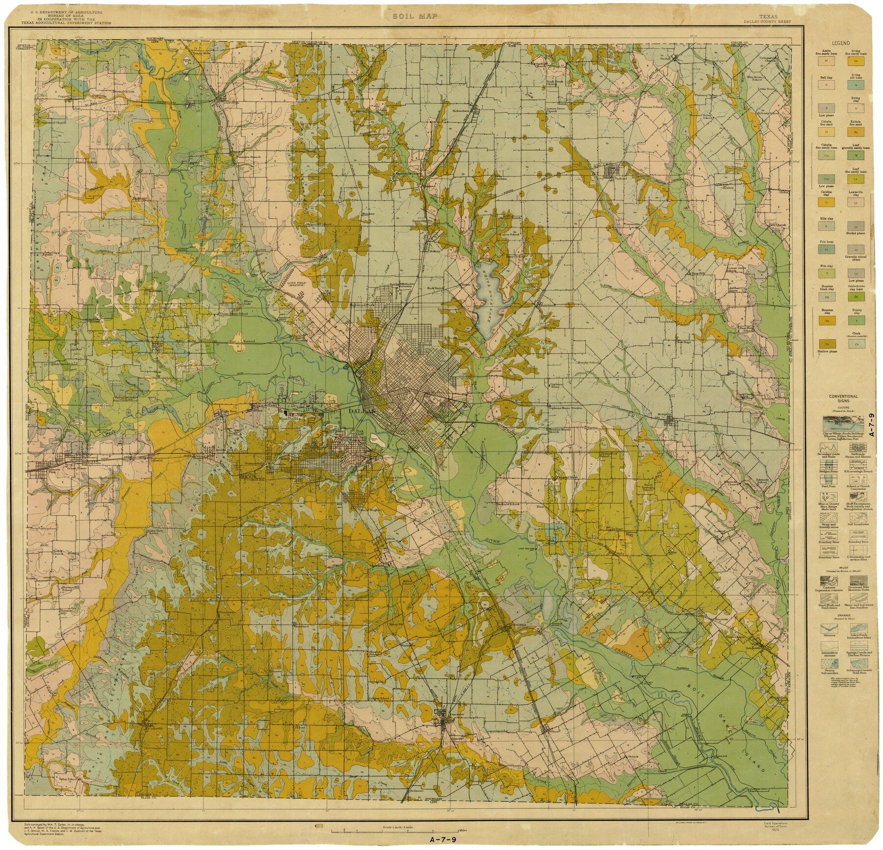
Dallas County
Soil Map Sheet
-
Map/Doc
2014
-
Collection
General Map Collection
-
Object Dates
1920 (Creation Date)
-
People and Organizations
Wm. T. Carter Jr. (Surveyor/Engineer)
T.M. Bushnell (Surveyor/Engineer)
W.B. Francis (Surveyor/Engineer)
J.F. Stroud (Surveyor/Engineer)
A.H. Bauer (Surveyor/Engineer)
-
Counties
Dallas
-
Subjects
County
-
Height x Width
33.9 x 35.0 inches
86.1 x 88.9 cm
-
Medium
print
-
Scale
1" = 1 mile
-
Comments
Field Operations, Bureau of Soils.
Part of: General Map Collection
Map of Sabine County

Print $20.00
- Digital $50.00
Map of Sabine County
1896
Size 26.6 x 19.3 inches
Map/Doc 4010
The State of Oklahoma

Print $20.00
- Digital $50.00
The State of Oklahoma
1916
Size 28.4 x 34.4 inches
Map/Doc 97104
Henderson County Rolled Sketch 11

Print $20.00
- Digital $50.00
Henderson County Rolled Sketch 11
1915
Size 29.1 x 42.4 inches
Map/Doc 75948
Terrell County Rolled Sketch 46

Print $20.00
- Digital $50.00
Terrell County Rolled Sketch 46
1958
Size 16.1 x 14.6 inches
Map/Doc 7948
Galveston County Rolled Sketch 16

Print $20.00
- Digital $50.00
Galveston County Rolled Sketch 16
1952
Size 43.6 x 38.0 inches
Map/Doc 9078
Pecos County Sketch File 29b

Print $12.00
- Digital $50.00
Pecos County Sketch File 29b
1929
Size 14.3 x 8.8 inches
Map/Doc 33692
Flight Mission No. DIX-10P, Frame 82, Aransas County

Print $20.00
- Digital $50.00
Flight Mission No. DIX-10P, Frame 82, Aransas County
1956
Size 18.8 x 22.4 inches
Map/Doc 83943
Coleman County

Print $20.00
- Digital $50.00
Coleman County
1862
Size 22.5 x 21.6 inches
Map/Doc 3414
Flight Mission No. CUG-1P, Frame 158, Kleberg County

Print $20.00
- Digital $50.00
Flight Mission No. CUG-1P, Frame 158, Kleberg County
1956
Size 18.5 x 22.3 inches
Map/Doc 86165
Flight Mission No. BRA-16M, Frame 56, Jefferson County

Print $20.00
- Digital $50.00
Flight Mission No. BRA-16M, Frame 56, Jefferson County
1953
Size 18.6 x 22.5 inches
Map/Doc 85673
Baylor County Working Sketch 11

Print $20.00
- Digital $50.00
Baylor County Working Sketch 11
1957
Size 20.0 x 47.8 inches
Map/Doc 67296
Grayson County Working Sketch 2

Print $20.00
- Digital $50.00
Grayson County Working Sketch 2
1939
Size 27.8 x 40.9 inches
Map/Doc 63241
You may also like
Kendall County Sketch File 7

Print $4.00
- Digital $50.00
Kendall County Sketch File 7
1848
Size 8.2 x 10.4 inches
Map/Doc 28688
[H. & G. N. RR. Co. Blks. 1 & 2]
![89771, [H. & G. N. RR. Co. Blks. 1 & 2], Twichell Survey Records](https://historictexasmaps.com/wmedia_w700/maps/89771-1.tif.jpg)
Print $20.00
- Digital $50.00
[H. & G. N. RR. Co. Blks. 1 & 2]
Size 40.9 x 46.6 inches
Map/Doc 89771
Flight Mission No. CGI-1N, Frame 143, Cameron County

Print $20.00
- Digital $50.00
Flight Mission No. CGI-1N, Frame 143, Cameron County
1955
Size 18.6 x 22.1 inches
Map/Doc 84499
[BIock D13, north part H. & G. N. Block 2]
![90378, [BIock D13, north part H. & G. N. Block 2], Twichell Survey Records](https://historictexasmaps.com/wmedia_w700/maps/90378-1.tif.jpg)
Print $20.00
- Digital $50.00
[BIock D13, north part H. & G. N. Block 2]
Size 14.9 x 20.5 inches
Map/Doc 90378
Lubbock County Sketch File 3

Print $4.00
- Digital $50.00
Lubbock County Sketch File 3
1901
Size 13.0 x 8.2 inches
Map/Doc 30420
Clay County Sketch File 1

Print $22.00
- Digital $50.00
Clay County Sketch File 1
1855
Size 8.9 x 7.6 inches
Map/Doc 18386
Midland County Working Sketch 30

Print $20.00
- Digital $50.00
Midland County Working Sketch 30
1971
Size 45.1 x 35.4 inches
Map/Doc 71011
Rio Grande Rectification Project, El Paso and Juarez Valley

Print $20.00
- Digital $50.00
Rio Grande Rectification Project, El Paso and Juarez Valley
1935
Size 10.8 x 29.6 inches
Map/Doc 60861
Nueces County Rolled Sketch 128 A-E

Print $10.00
- Digital $50.00
Nueces County Rolled Sketch 128 A-E
1998
Size 11.0 x 8.5 inches
Map/Doc 41611
Pecos County Sketch File 37

Print $4.00
- Digital $50.00
Pecos County Sketch File 37
1911
Size 8.9 x 8.3 inches
Map/Doc 33718
Young County Rolled Sketch 13

Print $20.00
- Digital $50.00
Young County Rolled Sketch 13
1966
Size 24.8 x 16.9 inches
Map/Doc 8301
Tom Green County Sketch File 46 1/2

Print $40.00
- Digital $50.00
Tom Green County Sketch File 46 1/2
1882
Size 12.7 x 19.6 inches
Map/Doc 12440