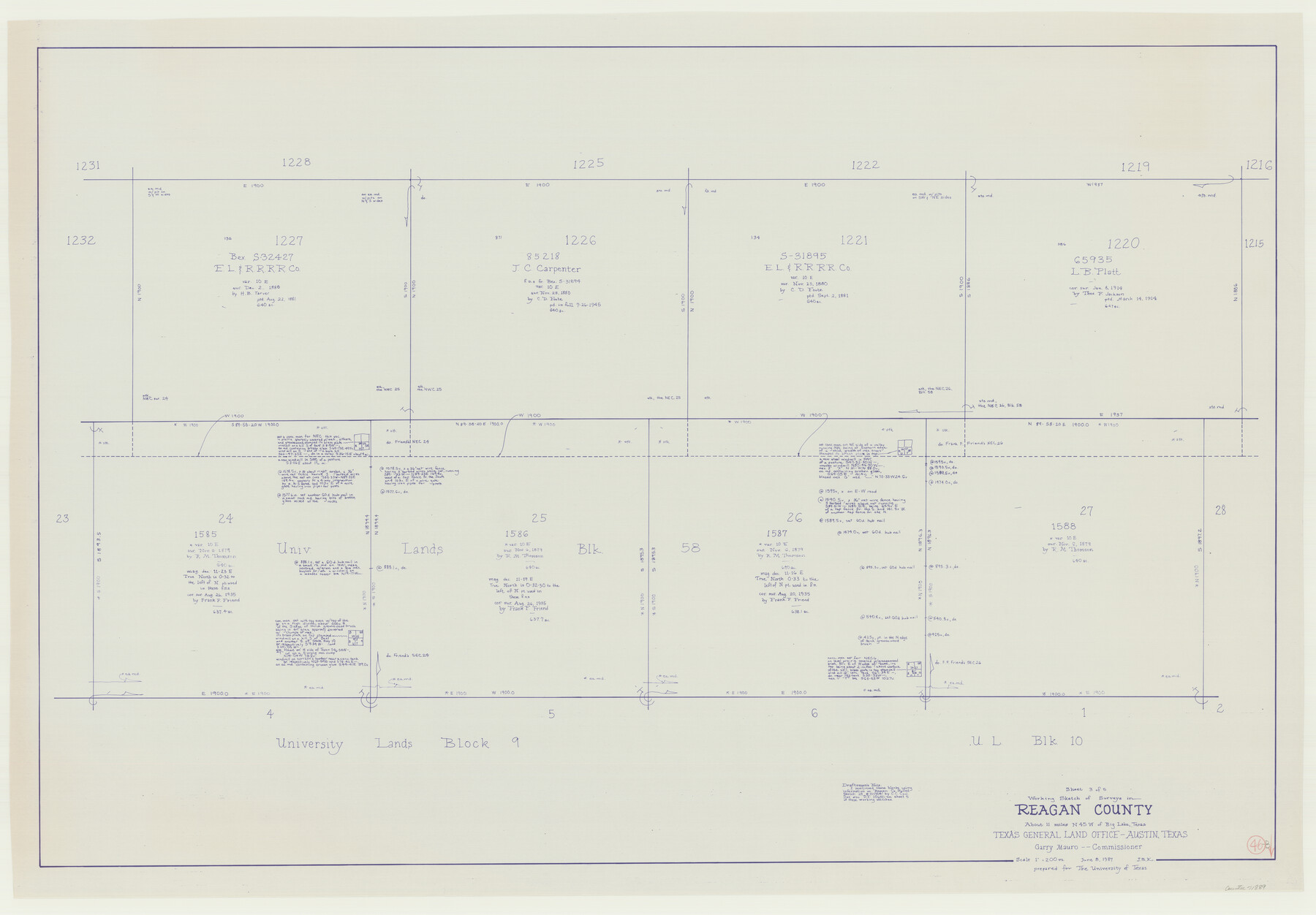
Reagan County Working Sketch 46b
-
Map/Doc
71889
-
Collection
General Map Collection
-
Object Dates
6/8/1987 (Creation Date)
-
People and Organizations
Joan Kilpatrick (Draftsman)
-
Counties
Reagan
-
Subjects
Surveying Working Sketch
-
Height x Width
31.4 x 45.2 inches
79.8 x 114.8 cm
-
Scale
1" = 200 varas
Part of: General Map Collection
Loving County Working Sketch 8

Print $40.00
- Digital $50.00
Loving County Working Sketch 8
1952
Size 21.9 x 56.6 inches
Map/Doc 70640
Sulphur River, Bassett Sheet

Print $20.00
- Digital $50.00
Sulphur River, Bassett Sheet
1939
Size 24.8 x 32.0 inches
Map/Doc 78322
Atascosa County Rolled Sketch 16

Print $20.00
- Digital $50.00
Atascosa County Rolled Sketch 16
1952
Size 22.7 x 38.3 inches
Map/Doc 5096
Southern Part of Laguna Madre

Print $20.00
- Digital $50.00
Southern Part of Laguna Madre
1969
Size 44.4 x 35.4 inches
Map/Doc 73541
Reeves County

Print $40.00
- Digital $50.00
Reeves County
1903
Size 48.7 x 36.5 inches
Map/Doc 16798
Flight Mission No. BRA-3M, Frame 127, Jefferson County

Print $20.00
- Digital $50.00
Flight Mission No. BRA-3M, Frame 127, Jefferson County
1953
Size 18.5 x 21.6 inches
Map/Doc 85401
Map of Hopkins County

Print $20.00
- Digital $50.00
Map of Hopkins County
1872
Size 17.8 x 18.4 inches
Map/Doc 4566
Nueces County Sketch File 82

Print $4.00
- Digital $50.00
Nueces County Sketch File 82
2000
Size 11.0 x 8.8 inches
Map/Doc 33165

Galveston County Rolled Sketch 18

Print $20.00
- Digital $50.00
Galveston County Rolled Sketch 18
1959
Size 27.9 x 35.8 inches
Map/Doc 5955
Wichita County Sketch File 5

Print $14.00
- Digital $50.00
Wichita County Sketch File 5
Size 8.2 x 14.5 inches
Map/Doc 40038
[Beaumont, Sour Lake and Western Ry. Right of Way and Alignment - Frisco]
![64126, [Beaumont, Sour Lake and Western Ry. Right of Way and Alignment - Frisco], General Map Collection](https://historictexasmaps.com/wmedia_w700/maps/64126.tif.jpg)
Print $20.00
- Digital $50.00
[Beaumont, Sour Lake and Western Ry. Right of Way and Alignment - Frisco]
1910
Size 20.1 x 46.1 inches
Map/Doc 64126
You may also like
Improving Sabine Pass, Texas. Surveyed May 10th to June 30th, 1894 under the direction of Major James B. Quinn, Corps of Engineers, USA

Print $20.00
- Digital $50.00
Improving Sabine Pass, Texas. Surveyed May 10th to June 30th, 1894 under the direction of Major James B. Quinn, Corps of Engineers, USA
1894
Size 9.3 x 13.2 inches
Map/Doc 94155
General Highway Map, Kenedy County, Texas

Print $20.00
General Highway Map, Kenedy County, Texas
1940
Size 18.4 x 24.9 inches
Map/Doc 79155
Galveston County NRC Article 33.136 Sketch 36

Print $28.00
- Digital $50.00
Galveston County NRC Article 33.136 Sketch 36
2005
Size 24.5 x 36.6 inches
Map/Doc 83409
Nueces County Rolled Sketch 61

Print $20.00
- Digital $50.00
Nueces County Rolled Sketch 61
1977
Size 32.2 x 39.3 inches
Map/Doc 6907
Reeves County Working Sketch 44

Print $20.00
- Digital $50.00
Reeves County Working Sketch 44
1974
Size 46.9 x 32.1 inches
Map/Doc 63487
Bexar County Sketch File 31

Print $40.00
- Digital $50.00
Bexar County Sketch File 31
1867
Size 11.3 x 16.4 inches
Map/Doc 10920
Kent County Sketch File 13

Print $6.00
- Digital $50.00
Kent County Sketch File 13
1921
Size 11.1 x 8.7 inches
Map/Doc 28839
Ward County Working Sketch 48

Print $20.00
- Digital $50.00
Ward County Working Sketch 48
1974
Size 28.2 x 44.1 inches
Map/Doc 72354
Rusk County Rolled Sketch OBS

Print $20.00
- Digital $50.00
Rusk County Rolled Sketch OBS
1937
Size 26.3 x 21.8 inches
Map/Doc 7550
[T. & P. Block U and H. & T. C. Block 1]
![91871, [T. & P. Block U and H. & T. C. Block 1], Twichell Survey Records](https://historictexasmaps.com/wmedia_w700/maps/91871-1.tif.jpg)
Print $20.00
- Digital $50.00
[T. & P. Block U and H. & T. C. Block 1]
Size 20.5 x 16.7 inches
Map/Doc 91871
Flight Mission No. DAG-26K, Frame 81, Matagorda County

Print $20.00
- Digital $50.00
Flight Mission No. DAG-26K, Frame 81, Matagorda County
1953
Size 18.5 x 22.2 inches
Map/Doc 86586
The Peters Colony. August 30, 1841

Print $20.00
The Peters Colony. August 30, 1841
2020
Size 21.7 x 21.7 inches
Map/Doc 96362