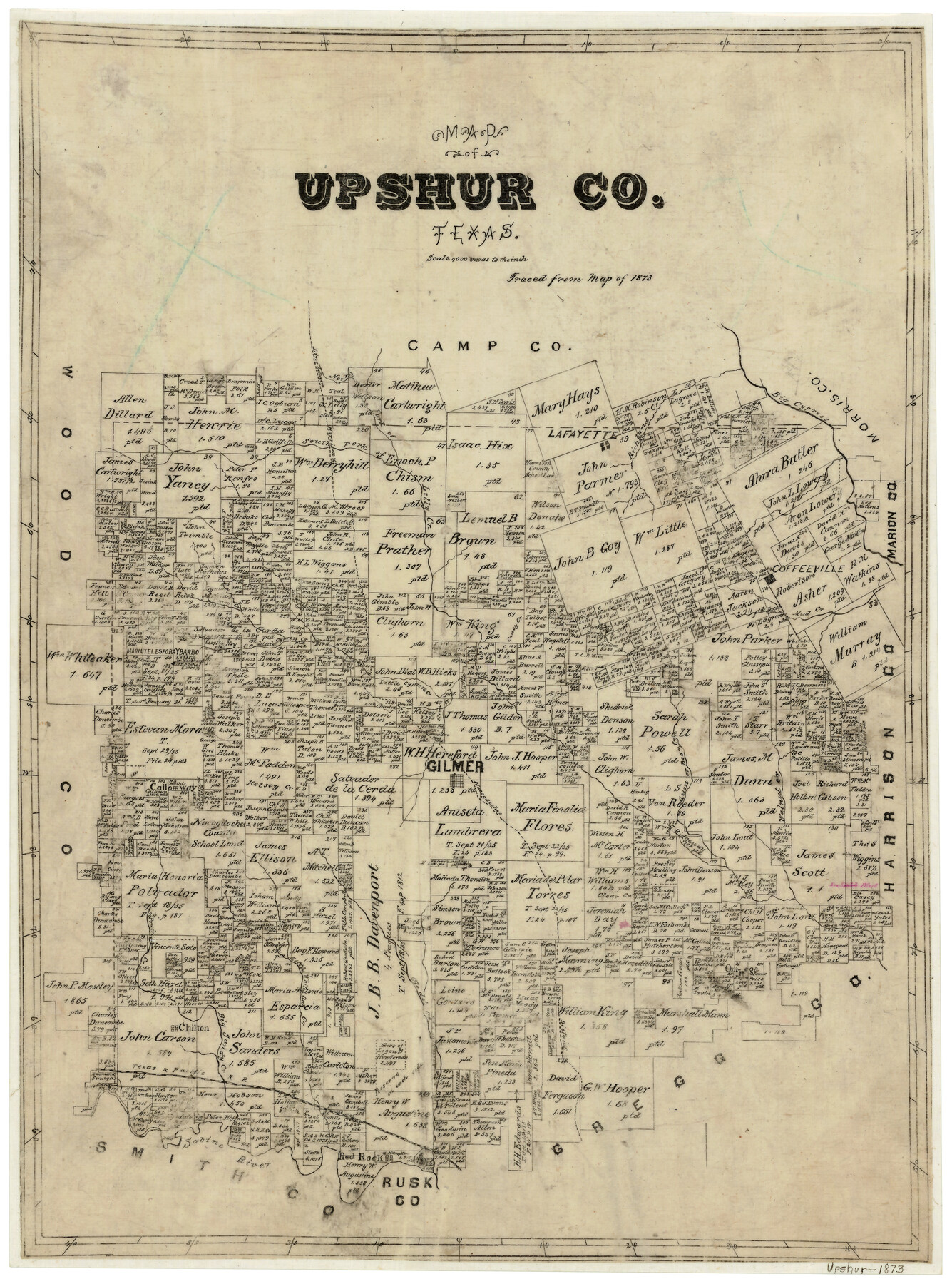
Map of Upshur County Texas
-
Map/Doc
4635
-
Collection
General Map Collection
-
Object Dates
1873 (Creation Date)
-
Counties
Upshur
-
Subjects
County
-
Height x Width
20.4 x 15.2 inches
51.8 x 38.6 cm
-
Comments
Note on map: "Traced from map of 1873".
-
Features
Bear Creek
Glade's Creek
Kelsey Creek
Mud Creek
Lilly Creek
Sabine River
T&P
Red Rock
Little White Oak Creek
Big Sandy Creek
Chilton
Prairie Creek
Glade Creek
Walnut Creek
North Fork of Lilly Creek
Gum Creek
Nacogdoches Road
Calloway
Clear Creek
Gilmer
Little Cypress Creek
Coffeeville
Caney Creek
Big Cypress Creek
Richland Creek
Lafayette
South Fork of Lilly Creek
Part of: General Map Collection

Val Verde County Sketch File XXX8

Print $6.00
- Digital $50.00
Val Verde County Sketch File XXX8
Size 9.0 x 16.4 inches
Map/Doc 39106
San Saba County Sketch File 12

Print $6.00
- Digital $50.00
San Saba County Sketch File 12
Size 11.8 x 9.3 inches
Map/Doc 36439
Montgomery County Working Sketch 50

Print $20.00
- Digital $50.00
Montgomery County Working Sketch 50
1959
Size 25.3 x 21.9 inches
Map/Doc 71157
Walker County Working Sketch 14

Print $40.00
- Digital $50.00
Walker County Working Sketch 14
1958
Size 19.8 x 51.0 inches
Map/Doc 72294
Galveston Bay, Texas

Print $20.00
- Digital $50.00
Galveston Bay, Texas
1905
Size 24.8 x 18.5 inches
Map/Doc 65390
Clay County Sketch File 37

Print $8.00
- Digital $50.00
Clay County Sketch File 37
1935
Size 11.6 x 7.2 inches
Map/Doc 18465
Bandera County Sketch File 29

Print $40.00
- Digital $50.00
Bandera County Sketch File 29
1939
Size 17.3 x 17.4 inches
Map/Doc 10898
Val Verde County Rolled Sketch 56

Print $20.00
- Digital $50.00
Val Verde County Rolled Sketch 56
1941
Size 39.3 x 22.8 inches
Map/Doc 8125
Wharton County Sketch File 11

Print $4.00
- Digital $50.00
Wharton County Sketch File 11
1891
Size 9.1 x 12.3 inches
Map/Doc 39933
Flight Mission No. DAG-21K, Frame 38, Matagorda County

Print $20.00
- Digital $50.00
Flight Mission No. DAG-21K, Frame 38, Matagorda County
1952
Size 18.6 x 22.3 inches
Map/Doc 86405
Pecos County Working Sketch 96

Print $20.00
- Digital $50.00
Pecos County Working Sketch 96
1970
Size 41.2 x 39.0 inches
Map/Doc 71569
You may also like
Dawson County Boundary File 2

Print $18.00
- Digital $50.00
Dawson County Boundary File 2
Size 14.2 x 8.8 inches
Map/Doc 52338
Briscoe County Working Sketch 11

Print $20.00
- Digital $50.00
Briscoe County Working Sketch 11
1982
Size 27.5 x 24.3 inches
Map/Doc 67814
Atascosa County Rolled Sketch 21

Print $20.00
- Digital $50.00
Atascosa County Rolled Sketch 21
1958
Size 25.0 x 38.0 inches
Map/Doc 5100
Matagorda County Sketch File 1

Print $4.00
- Digital $50.00
Matagorda County Sketch File 1
1876
Size 13.0 x 8.8 inches
Map/Doc 30728
Randall County Rolled Sketch 9

Print $20.00
- Digital $50.00
Randall County Rolled Sketch 9
Size 47.5 x 35.8 inches
Map/Doc 9808
Stephens County Sketch File 15

Print $4.00
- Digital $50.00
Stephens County Sketch File 15
1890
Size 9.1 x 6.7 inches
Map/Doc 37068
McLennan County

Print $20.00
- Digital $50.00
McLennan County
1946
Size 42.5 x 45.8 inches
Map/Doc 73235
Goliad County Working Sketch 3

Print $40.00
- Digital $50.00
Goliad County Working Sketch 3
1916
Size 42.8 x 76.4 inches
Map/Doc 63193
Galveston County Rolled Sketch Z63

Print $20.00
- Digital $50.00
Galveston County Rolled Sketch Z63
1935
Size 34.6 x 22.5 inches
Map/Doc 5995
Montague County Working Sketch 46

Print $20.00
- Digital $50.00
Montague County Working Sketch 46
2014
Size 14.7 x 20.4 inches
Map/Doc 93689
Brazos County Rolled Sketch 6

Print $20.00
- Digital $50.00
Brazos County Rolled Sketch 6
1979
Size 24.3 x 36.4 inches
Map/Doc 5190
Map showing lands of D. Sullivan situated in Starr County, Texas

Print $20.00
- Digital $50.00
Map showing lands of D. Sullivan situated in Starr County, Texas
Size 15.5 x 18.6 inches
Map/Doc 755