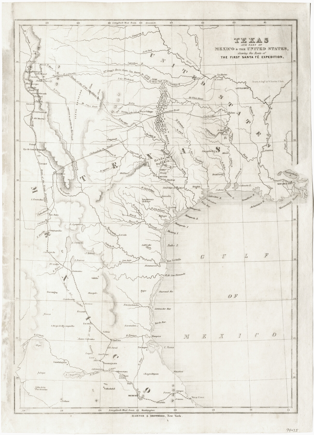
Texas and part of Mexico & the United States, showing the route of the first Santa Fe Expedition
-
Map/Doc
94035
-
Collection
General Map Collection
-
Object Dates
1844 (Creation Date)
-
People and Organizations
Harper & Brothers (Publisher)
W. Kemble (Printer)
W. Kemble (Engraver)
-
Subjects
Military Republic of Texas
-
Height x Width
18.1 x 13.2 inches
46.0 x 33.5 cm
-
Medium
paper, etching/engraving/lithograph
Part of: General Map Collection
[Right of Way and Track Map, the Missouri, Kansas and Texas Ry. of Texas - Henrietta Division]
![64766, [Right of Way and Track Map, the Missouri, Kansas and Texas Ry. of Texas - Henrietta Division], General Map Collection](https://historictexasmaps.com/wmedia_w700/maps/64766.tif.jpg)
Print $20.00
- Digital $50.00
[Right of Way and Track Map, the Missouri, Kansas and Texas Ry. of Texas - Henrietta Division]
1918
Size 11.8 x 26.9 inches
Map/Doc 64766
Midland County Rolled Sketch 14

Print $40.00
- Digital $50.00
Midland County Rolled Sketch 14
Size 56.6 x 43.5 inches
Map/Doc 73574
Mississippi River to Galveston

Print $40.00
- Digital $50.00
Mississippi River to Galveston
1986
Size 36.8 x 49.9 inches
Map/Doc 69948
Liberty County Working Sketch 66

Print $40.00
- Digital $50.00
Liberty County Working Sketch 66
1970
Size 42.9 x 49.9 inches
Map/Doc 70526

Map of Pecos Co.

Print $40.00
- Digital $50.00
Map of Pecos Co.
1896
Size 47.7 x 70.1 inches
Map/Doc 76038
Flight Mission No. DAG-22K, Frame 77, Matagorda County

Print $20.00
- Digital $50.00
Flight Mission No. DAG-22K, Frame 77, Matagorda County
1953
Size 18.6 x 22.4 inches
Map/Doc 86464
Dawson County Working Sketch 5

Print $20.00
- Digital $50.00
Dawson County Working Sketch 5
1926
Size 22.3 x 26.1 inches
Map/Doc 68548
Flight Mission No. CGI-3N, Frame 187, Cameron County

Print $20.00
- Digital $50.00
Flight Mission No. CGI-3N, Frame 187, Cameron County
1954
Size 18.5 x 22.2 inches
Map/Doc 84651
[Sketch for Mineral Application 27669 - Trinity River, Frank R. Graves]
![2861, [Sketch for Mineral Application 27669 - Trinity River, Frank R. Graves], General Map Collection](https://historictexasmaps.com/wmedia_w700/maps/2861-1.tif.jpg)
Print $40.00
- Digital $50.00
[Sketch for Mineral Application 27669 - Trinity River, Frank R. Graves]
1934
Size 27.4 x 61.6 inches
Map/Doc 2861
Map of the Fort Worth & Denver City Railway

Print $40.00
- Digital $50.00
Map of the Fort Worth & Denver City Railway
1887
Size 21.7 x 72.8 inches
Map/Doc 64479
Stephens County Working Sketch 12

Print $20.00
- Digital $50.00
Stephens County Working Sketch 12
1947
Size 20.9 x 22.2 inches
Map/Doc 63955
You may also like
Smith County Sketch File 4

Print $4.00
- Digital $50.00
Smith County Sketch File 4
1853
Size 10.3 x 8.1 inches
Map/Doc 36752
McMullen County Working Sketch 52

Print $20.00
- Digital $50.00
McMullen County Working Sketch 52
1983
Size 18.0 x 19.4 inches
Map/Doc 70753
Flight Mission No. CRK-8P, Frame 122, Refugio County

Print $20.00
- Digital $50.00
Flight Mission No. CRK-8P, Frame 122, Refugio County
1956
Size 18.4 x 22.1 inches
Map/Doc 86977
Jim Hogg County Rolled Sketch 9

Print $20.00
- Digital $50.00
Jim Hogg County Rolled Sketch 9
1974
Size 18.2 x 19.8 inches
Map/Doc 6443
Lipscomb County Rolled Sketch 3

Print $20.00
- Digital $50.00
Lipscomb County Rolled Sketch 3
1886
Size 24.2 x 31.0 inches
Map/Doc 6629
Map of the Globe showing its continents, islands, mountain ranges, table lands, plains and slopes

Print $20.00
- Digital $50.00
Map of the Globe showing its continents, islands, mountain ranges, table lands, plains and slopes
1885
Size 12.2 x 18.5 inches
Map/Doc 93532
Kimble County Working Sketch 75

Print $20.00
- Digital $50.00
Kimble County Working Sketch 75
1968
Size 32.0 x 35.7 inches
Map/Doc 70143
Lamar County Working Sketch 8

Print $20.00
- Digital $50.00
Lamar County Working Sketch 8
1969
Size 39.3 x 31.6 inches
Map/Doc 70269
Galveston County Rolled Sketch Z61

Print $20.00
- Digital $50.00
Galveston County Rolled Sketch Z61
1934
Size 34.9 x 23.0 inches
Map/Doc 5993
Hudspeth County Working Sketch 20

Print $40.00
- Digital $50.00
Hudspeth County Working Sketch 20
1966
Size 43.8 x 63.6 inches
Map/Doc 66302
Duval County Sketch File 6b

Print $5.00
- Digital $50.00
Duval County Sketch File 6b
1875
Size 8.3 x 10.8 inches
Map/Doc 21290
Wood County Sketch File 9

Print $4.00
- Digital $50.00
Wood County Sketch File 9
1852
Size 7.4 x 8.9 inches
Map/Doc 40656