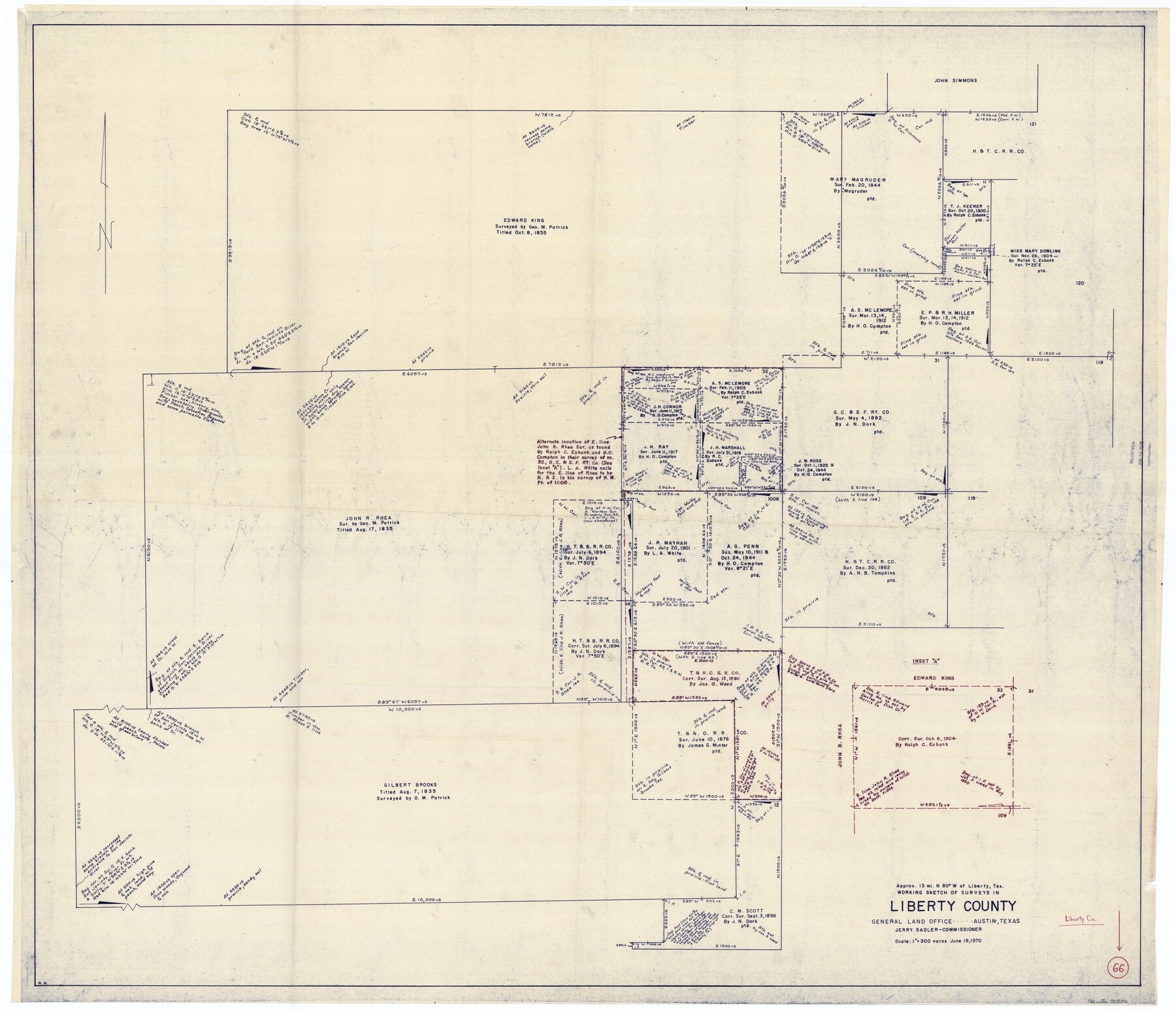
Liberty County Working Sketch 66
-
Map/Doc
70526
-
Collection
General Map Collection
-
Object Dates
6/19/1970 (Creation Date)
-
People and Organizations
Roy Buckholts (Draftsman)
-
Counties
Liberty
-
Subjects
Surveying Working Sketch
-
Height x Width
42.9 x 49.9 inches
109.0 x 126.8 cm
-
Scale
1" = 300 varas
Part of: General Map Collection
Flight Mission No. BRA-7M, Frame 192, Jefferson County

Print $20.00
- Digital $50.00
Flight Mission No. BRA-7M, Frame 192, Jefferson County
1953
Size 18.5 x 22.4 inches
Map/Doc 85560
Map of the Straits of Florida and Gulf of Mexico

Print $20.00
- Digital $50.00
Map of the Straits of Florida and Gulf of Mexico
1851
Size 18.4 x 27.5 inches
Map/Doc 72674
Flight Mission No. BRA-8M, Frame 127, Jefferson County

Print $20.00
- Digital $50.00
Flight Mission No. BRA-8M, Frame 127, Jefferson County
1953
Size 18.6 x 22.3 inches
Map/Doc 85623
Flight Mission No. DCL-4C, Frame 97, Kenedy County

Print $20.00
- Digital $50.00
Flight Mission No. DCL-4C, Frame 97, Kenedy County
1943
Size 18.6 x 22.4 inches
Map/Doc 85818
Schleicher County Sketch File 6

Print $4.00
- Digital $50.00
Schleicher County Sketch File 6
Size 8.1 x 8.5 inches
Map/Doc 36472
Flight Mission No. DQO-8K, Frame 53, Galveston County

Print $20.00
- Digital $50.00
Flight Mission No. DQO-8K, Frame 53, Galveston County
1952
Size 18.6 x 22.3 inches
Map/Doc 85160
McCulloch County Working Sketch Graphic Index

Print $20.00
- Digital $50.00
McCulloch County Working Sketch Graphic Index
1949
Size 47.3 x 37.4 inches
Map/Doc 76636
Newton County Working Sketch 18

Print $20.00
- Digital $50.00
Newton County Working Sketch 18
1950
Size 14.3 x 13.6 inches
Map/Doc 71264
Dawson County Sketch File 15

Print $40.00
- Digital $50.00
Dawson County Sketch File 15
Size 17.8 x 7.9 inches
Map/Doc 20549
Brewster County Rolled Sketch 94

Print $40.00
- Digital $50.00
Brewster County Rolled Sketch 94
1941
Size 26.8 x 58.6 inches
Map/Doc 8507
Reeves County Boundary File 1

Print $12.00
- Digital $50.00
Reeves County Boundary File 1
Size 14.1 x 8.5 inches
Map/Doc 58195
The Texas and Pacific Ry. Co., Station Map, Loraine, Texas

Print $20.00
- Digital $50.00
The Texas and Pacific Ry. Co., Station Map, Loraine, Texas
Size 11.6 x 18.6 inches
Map/Doc 64683
You may also like
Gillespie County Boundary File 7a

Print $40.00
- Digital $50.00
Gillespie County Boundary File 7a
Size 8.7 x 51.2 inches
Map/Doc 53780
University of Texas System University Lands

Print $20.00
- Digital $50.00
University of Texas System University Lands
1931
Size 23.2 x 17.5 inches
Map/Doc 93241
Garza County Working Sketch 9

Print $20.00
- Digital $50.00
Garza County Working Sketch 9
1952
Size 15.7 x 18.0 inches
Map/Doc 63156
[Corpus Christi Bay, Padre Island, Mustang Island, Laguna de la Madre, King and Kenedy's Pasture]
![73040, [Corpus Christi Bay, Padre Island, Mustang Island, Laguna de la Madre, King and Kenedy's Pasture], General Map Collection](https://historictexasmaps.com/wmedia_w700/maps/73040.tif.jpg)
Print $20.00
- Digital $50.00
[Corpus Christi Bay, Padre Island, Mustang Island, Laguna de la Madre, King and Kenedy's Pasture]
Size 18.2 x 27.0 inches
Map/Doc 73040
Sketch of surveys in Shelby Co.

Print $2.00
- Digital $50.00
Sketch of surveys in Shelby Co.
1845
Size 6.4 x 8.8 inches
Map/Doc 69741
Duval County Rolled Sketch 37

Print $20.00
- Digital $50.00
Duval County Rolled Sketch 37
Size 27.1 x 17.9 inches
Map/Doc 5752
Flight Mission No. DAH-9M, Frame 162, Orange County

Print $20.00
- Digital $50.00
Flight Mission No. DAH-9M, Frame 162, Orange County
1953
Size 18.6 x 22.3 inches
Map/Doc 86861
Leon County Working Sketch 21

Print $20.00
- Digital $50.00
Leon County Working Sketch 21
1964
Size 20.9 x 22.9 inches
Map/Doc 70420
Howard County Working Sketch 2

Print $20.00
- Digital $50.00
Howard County Working Sketch 2
1903
Size 21.7 x 20.9 inches
Map/Doc 66268
Kendall County Boundary File 3a

Print $8.00
- Digital $50.00
Kendall County Boundary File 3a
Size 11.2 x 8.9 inches
Map/Doc 55765
Flight Mission No. DAG-19K, Frame 65, Matagorda County

Print $20.00
- Digital $50.00
Flight Mission No. DAG-19K, Frame 65, Matagorda County
1952
Size 18.5 x 22.3 inches
Map/Doc 86392
[Blocks 1, 2, 8, B4, B5 and others in vicinity]
![91816, [Blocks 1, 2, 8, B4, B5 and others in vicinity], Twichell Survey Records](https://historictexasmaps.com/wmedia_w700/maps/91816-1.tif.jpg)
Print $20.00
- Digital $50.00
[Blocks 1, 2, 8, B4, B5 and others in vicinity]
Size 29.1 x 32.6 inches
Map/Doc 91816