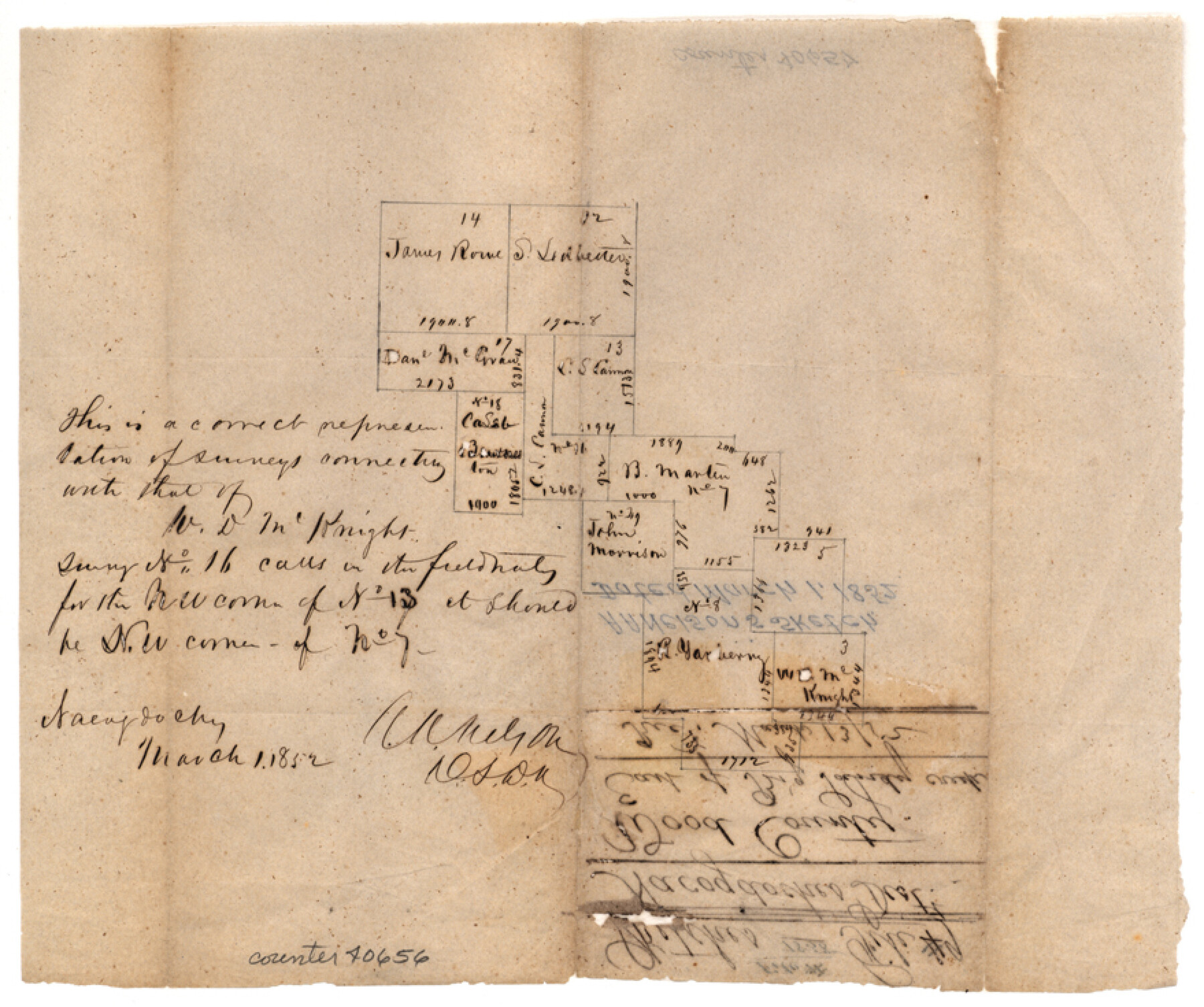
Wood County Sketch File 9
[Sketch of surveys east of Big Sandy Creek near the east county boundary line]
-
Map/Doc
40656
-
Collection
General Map Collection
-
Object Dates
3/1/1852 (Creation Date)
-
People and Organizations
A.A. Nelson (Surveyor/Engineer)
-
Counties
Wood
-
Subjects
Surveying Sketch File
-
Height x Width
7.4 x 8.9 inches
18.8 x 22.6 cm
-
Medium
paper, manuscript
-
Features
Big Sandy Creek
Part of: General Map Collection
Frio County Working Sketch 10

Print $20.00
- Digital $50.00
Frio County Working Sketch 10
1951
Size 27.0 x 27.3 inches
Map/Doc 69284
Irion County Sketch File 8

Print $6.00
- Digital $50.00
Irion County Sketch File 8
Size 14.5 x 9.8 inches
Map/Doc 27473
Flight Mission No. DQO-11K, Frame 26, Galveston County

Print $20.00
- Digital $50.00
Flight Mission No. DQO-11K, Frame 26, Galveston County
1952
Size 18.8 x 22.5 inches
Map/Doc 85223
Atascosa County Sketch File 27a

Print $4.00
- Digital $50.00
Atascosa County Sketch File 27a
Size 8.4 x 14.3 inches
Map/Doc 13799
Clay County Boundary File 7

Print $14.00
- Digital $50.00
Clay County Boundary File 7
Size 14.3 x 8.8 inches
Map/Doc 51377
Crosby County Working Sketch 13

Print $20.00
- Digital $50.00
Crosby County Working Sketch 13
1963
Size 17.9 x 30.7 inches
Map/Doc 68447
Crockett County Sketch File 33

Print $30.00
- Digital $50.00
Crockett County Sketch File 33
1883
Size 13.0 x 8.2 inches
Map/Doc 19731
Hutchinson County

Print $20.00
- Digital $50.00
Hutchinson County
1884
Size 20.8 x 19.0 inches
Map/Doc 3694
Flight Mission No. DIX-10P, Frame 181, Aransas County

Print $20.00
- Digital $50.00
Flight Mission No. DIX-10P, Frame 181, Aransas County
1956
Size 18.5 x 22.2 inches
Map/Doc 83971
Zavala County Working Sketch 7

Print $20.00
- Digital $50.00
Zavala County Working Sketch 7
1948
Size 19.3 x 17.3 inches
Map/Doc 62082
Brewster County Sketch File FN-30

Print $4.00
- Digital $50.00
Brewster County Sketch File FN-30
1975
Size 12.0 x 8.7 inches
Map/Doc 15850
Map of the City of Kerens (Navarro County) Texas

Print $40.00
- Digital $50.00
Map of the City of Kerens (Navarro County) Texas
1958
Size 44.2 x 54.9 inches
Map/Doc 93670
You may also like
Tarrant County Sketch File 15

Print $4.00
- Digital $50.00
Tarrant County Sketch File 15
1859
Size 13.2 x 8.1 inches
Map/Doc 37708
Presidio County Sketch File 115

Print $14.00
- Digital $50.00
Presidio County Sketch File 115
1993
Size 11.3 x 8.9 inches
Map/Doc 34835
Howard County Working Sketch 13

Print $20.00
- Digital $50.00
Howard County Working Sketch 13
1983
Size 33.3 x 37.3 inches
Map/Doc 66281
Clay County Sketch File 46

Print $20.00
- Digital $50.00
Clay County Sketch File 46
1890
Size 18.9 x 19.3 inches
Map/Doc 11098
Montague County Working Sketch 19

Print $20.00
- Digital $50.00
Montague County Working Sketch 19
1952
Size 26.4 x 21.5 inches
Map/Doc 71085
Flight Mission No. BRA-6M, Frame 147, Jefferson County

Print $20.00
- Digital $50.00
Flight Mission No. BRA-6M, Frame 147, Jefferson County
1953
Size 18.6 x 22.4 inches
Map/Doc 85448
[I. & G. N. Block 1, sections 64, 65, 67-71 and 545 along river]
![91605, [I. & G. N. Block 1, sections 64, 65, 67-71 and 545 along river], Twichell Survey Records](https://historictexasmaps.com/wmedia_w700/maps/91605-1.tif.jpg)
Print $2.00
- Digital $50.00
[I. & G. N. Block 1, sections 64, 65, 67-71 and 545 along river]
Size 9.1 x 14.7 inches
Map/Doc 91605
Flight Mission No. DQN-6K, Frame 89, Calhoun County

Print $20.00
- Digital $50.00
Flight Mission No. DQN-6K, Frame 89, Calhoun County
1953
Size 18.5 x 22.2 inches
Map/Doc 84449
Armstrong County

Print $20.00
- Digital $50.00
Armstrong County
1904
Size 40.4 x 33.8 inches
Map/Doc 3247

Hardin County Working Sketch 13

Print $20.00
- Digital $50.00
Hardin County Working Sketch 13
1934
Size 25.5 x 17.6 inches
Map/Doc 63411
Lubbock County

Print $20.00
- Digital $50.00
Lubbock County
1892
Size 25.0 x 20.6 inches
Map/Doc 66910