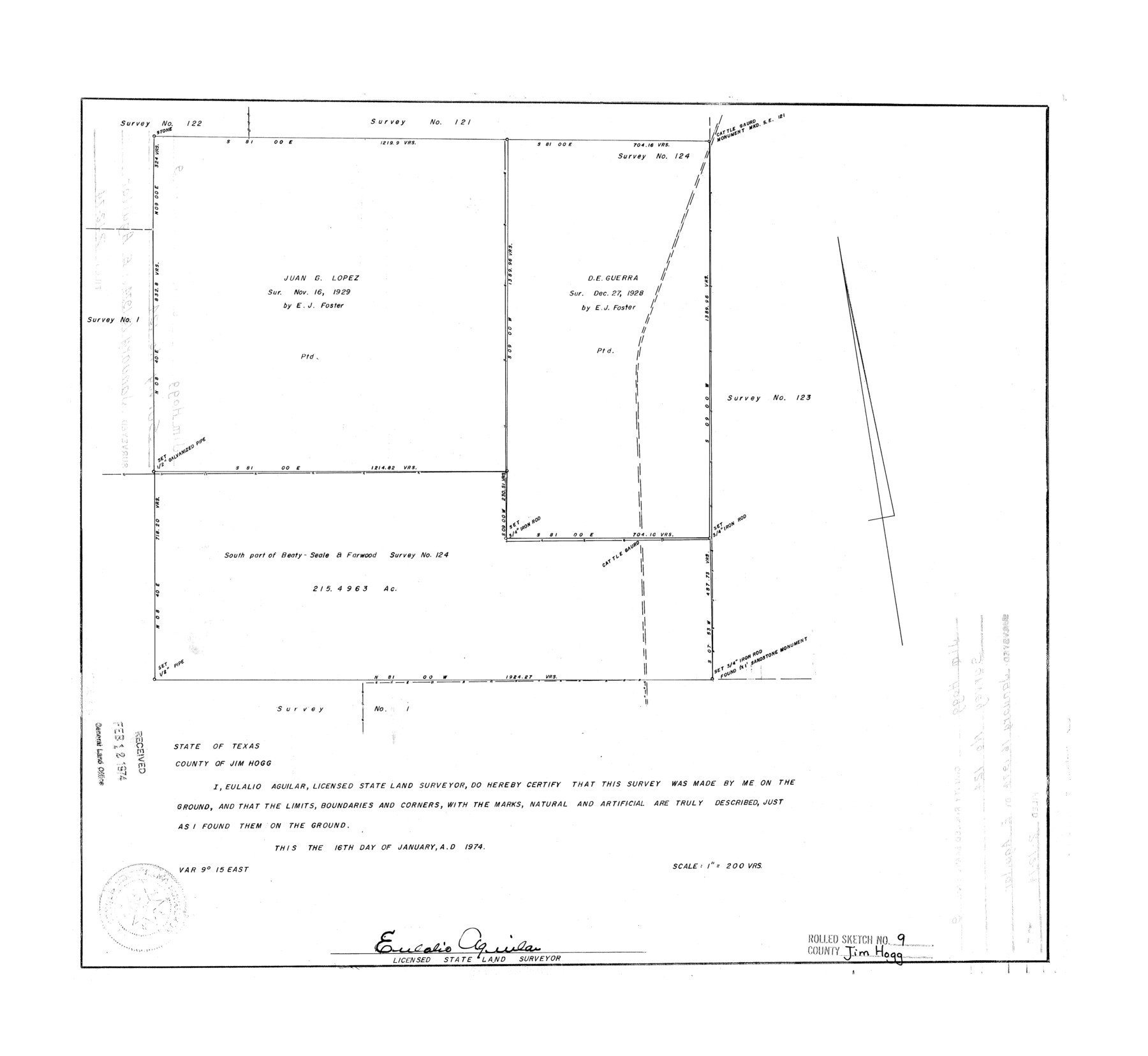
Jim Hogg County Rolled Sketch 9
[Sketch of survey 124 and surrounding area]
-
Map/Doc
6443
-
Collection
General Map Collection
-
Object Dates
1974/1/16 (Creation Date)
1974/2/12 (File Date)
-
People and Organizations
Eulalio Aguilar (Surveyor/Engineer)
-
Counties
Jim Hogg
-
Subjects
Surveying Rolled Sketch
-
Height x Width
18.2 x 19.8 inches
46.2 x 50.3 cm
-
Scale
1" = 200 varas
Part of: General Map Collection
San Patricio County Rolled Sketch 34

Print $20.00
- Digital $50.00
San Patricio County Rolled Sketch 34
Size 25.8 x 26.2 inches
Map/Doc 7584
Harris County

Print $20.00
- Digital $50.00
Harris County
1940
Size 36.8 x 45.2 inches
Map/Doc 77304
Pecos County Sketch File 76A

Print $20.00
- Digital $50.00
Pecos County Sketch File 76A
Size 16.1 x 18.3 inches
Map/Doc 12182
Trinity County Sketch File 16

Print $4.00
- Digital $50.00
Trinity County Sketch File 16
1879
Size 8.2 x 11.1 inches
Map/Doc 38544
Reagan County Sketch File 11

Print $20.00
- Digital $50.00
Reagan County Sketch File 11
1928
Size 26.7 x 22.2 inches
Map/Doc 12217
Garza County Rolled Sketch 6D

Print $20.00
- Digital $50.00
Garza County Rolled Sketch 6D
1913
Size 17.4 x 16.0 inches
Map/Doc 5998
Menard County Working Sketch 10

Print $20.00
- Digital $50.00
Menard County Working Sketch 10
1938
Size 21.8 x 18.5 inches
Map/Doc 70957
Childress County Rolled Sketch 1

Print $20.00
- Digital $50.00
Childress County Rolled Sketch 1
Size 31.2 x 26.5 inches
Map/Doc 5437
Val Verde County Working Sketch 6

Print $20.00
- Digital $50.00
Val Verde County Working Sketch 6
1915
Size 23.2 x 20.7 inches
Map/Doc 72141
La Salle County Working Sketch 56

Print $20.00
- Digital $50.00
La Salle County Working Sketch 56
2012
Size 25.5 x 23.0 inches
Map/Doc 93277
Wharton County Sketch File 21

Print $40.00
- Digital $50.00
Wharton County Sketch File 21
1911
Size 14.8 x 13.0 inches
Map/Doc 39986
Flight Mission No. DAH-17M, Frame 62, Orange County

Print $20.00
- Digital $50.00
Flight Mission No. DAH-17M, Frame 62, Orange County
1953
Size 18.5 x 22.6 inches
Map/Doc 86896
You may also like
Navigation District Property Map, Port of Houston, Harris County Houston Ship Channel Navigation District, Houston, Texas

Print $40.00
- Digital $50.00
Navigation District Property Map, Port of Houston, Harris County Houston Ship Channel Navigation District, Houston, Texas
1955
Size 26.9 x 68.7 inches
Map/Doc 2103
Duval County Sketch File 62

Print $40.00
- Digital $50.00
Duval County Sketch File 62
1941
Size 14.0 x 12.5 inches
Map/Doc 21434
Jefferson County NRC Article 33.136 Sketch 5

Print $4.00
- Digital $50.00
Jefferson County NRC Article 33.136 Sketch 5
2005
Size 14.1 x 8.8 inches
Map/Doc 83170
Williamson County Sketch File 7

Print $4.00
- Digital $50.00
Williamson County Sketch File 7
1847
Size 12.7 x 7.7 inches
Map/Doc 40316
Flight Mission No. CRC-3R, Frame 167, Chambers County

Print $20.00
- Digital $50.00
Flight Mission No. CRC-3R, Frame 167, Chambers County
1956
Size 18.7 x 22.3 inches
Map/Doc 84849
Subdivision for R.N. Graham

Print $3.00
- Digital $50.00
Subdivision for R.N. Graham
1913
Size 10.4 x 15.2 inches
Map/Doc 473
Val Verde County Rolled Sketch 70

Print $20.00
- Digital $50.00
Val Verde County Rolled Sketch 70
1958
Size 23.2 x 18.8 inches
Map/Doc 8132
University Land Field Notes for Block L in El Paso County

University Land Field Notes for Block L in El Paso County
Map/Doc 81725
Kenedy County Boundary File 2

Print $22.00
- Digital $50.00
Kenedy County Boundary File 2
Size 11.2 x 8.6 inches
Map/Doc 55782
Hutchinson County Rolled Sketch 37

Print $20.00
- Digital $50.00
Hutchinson County Rolled Sketch 37
1950
Size 24.4 x 44.4 inches
Map/Doc 6296
Starr County Sketch File 28

Print $12.00
- Digital $50.00
Starr County Sketch File 28
1933
Size 11.2 x 8.8 inches
Map/Doc 36948
Map of Cherokee County

Print $40.00
- Digital $50.00
Map of Cherokee County
1933
Size 55.0 x 38.7 inches
Map/Doc 95453