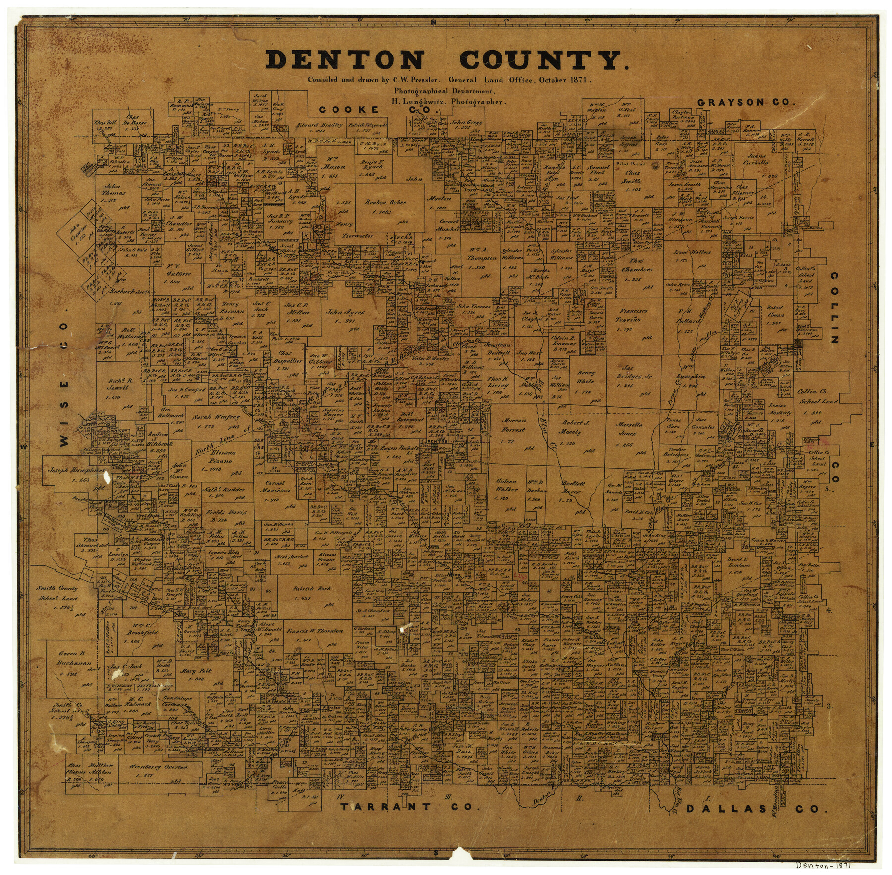
Denton County
-
Map/Doc
3474
-
Collection
General Map Collection
-
Object Dates
10/1871 (Creation Date)
-
People and Organizations
Herman Lungkwitz (Photographer)
Chas. W. Pressler (Draftsman)
-
Counties
Denton
-
Subjects
County
-
Height x Width
18.8 x 19.1 inches
47.8 x 48.5 cm
-
Features
Denton
Harriet's Creek
Indian Creek
Elizabeth's Creek
Henrietta's Creek
Oliver's Creek
Elm Fork of Oliver's Creek
Denton Fork of Big Elm Creek
Alton
Stewart's Creek
Panther Creek
Pilot Knob
Brooks Creek
Hickory Creek
South Fork of Hickory Creek
Doe Creek
Big Elm Creek
Pecan Creek
Mustang Creek
Little Elm Creek
MEP&P
Clear Creek
Pilot Point
Isle du Bois Creek
Pond Creek
Spring Creek
Duck Creek
Fannin's Creek
Timber Creek
Trail Creek
Part of: General Map Collection
Blanco County Rolled Sketch 15

Print $20.00
- Digital $50.00
Blanco County Rolled Sketch 15
Size 12.9 x 13.7 inches
Map/Doc 5151
Tom Green County Sketch File 85

Print $4.00
- Digital $50.00
Tom Green County Sketch File 85
1912
Size 11.4 x 9.0 inches
Map/Doc 38256
Lampasas County Sketch File 16

Print $20.00
- Digital $50.00
Lampasas County Sketch File 16
1893
Size 22.8 x 20.8 inches
Map/Doc 11976
[Plat of Colorado River Survey, McCulloch County]
![2462, [Plat of Colorado River Survey, McCulloch County], General Map Collection](https://historictexasmaps.com/wmedia_w700/maps/2462-1.tif.jpg)
Print $40.00
- Digital $50.00
[Plat of Colorado River Survey, McCulloch County]
1918
Size 40.3 x 159.2 inches
Map/Doc 2462
Real County Working Sketch 43

Print $20.00
- Digital $50.00
Real County Working Sketch 43
1953
Size 32.4 x 30.5 inches
Map/Doc 71935
PSL Field Notes for Block 54 1/2 in Culberson and Hudspeth Counties, and Blocks 44, 45 1/2, 46, 47 1/2, 48, 49, 50, 51, 52 1/2, 53 1/2, 55 1/2, 56, and 57 in Hudspeth County

PSL Field Notes for Block 54 1/2 in Culberson and Hudspeth Counties, and Blocks 44, 45 1/2, 46, 47 1/2, 48, 49, 50, 51, 52 1/2, 53 1/2, 55 1/2, 56, and 57 in Hudspeth County
Map/Doc 81661
Deaf Smith County Rolled Sketch 3

Print $20.00
- Digital $50.00
Deaf Smith County Rolled Sketch 3
Size 23.9 x 18.0 inches
Map/Doc 95707
Kaufman County Boundary File 6

Print $14.00
- Digital $50.00
Kaufman County Boundary File 6
Size 11.2 x 8.7 inches
Map/Doc 55956
Brooks County Rolled Sketch 22

Print $20.00
- Digital $50.00
Brooks County Rolled Sketch 22
1943
Size 15.1 x 32.2 inches
Map/Doc 5343
Concho County Sketch File 26

Print $6.00
- Digital $50.00
Concho County Sketch File 26
1885
Size 11.5 x 9.0 inches
Map/Doc 19159
Flight Mission No. CRC-3R, Frame 10, Chambers County

Print $20.00
- Digital $50.00
Flight Mission No. CRC-3R, Frame 10, Chambers County
1956
Size 18.5 x 22.2 inches
Map/Doc 84784
Roberts County Working Sketch 10

Print $20.00
- Digital $50.00
Roberts County Working Sketch 10
1965
Size 23.0 x 29.0 inches
Map/Doc 63536
You may also like
Galveston County Working Sketch 19

Print $20.00
- Digital $50.00
Galveston County Working Sketch 19
1983
Size 28.7 x 38.6 inches
Map/Doc 69356
Fisher County Sketch File 19

Print $20.00
- Digital $50.00
Fisher County Sketch File 19
Size 18.8 x 15.7 inches
Map/Doc 11481
Red River County Working Sketch 43

Print $40.00
- Digital $50.00
Red River County Working Sketch 43
1968
Size 72.5 x 36.8 inches
Map/Doc 72026
Flight Mission No. DCL-6C, Frame 180, Kenedy County

Print $20.00
- Digital $50.00
Flight Mission No. DCL-6C, Frame 180, Kenedy County
1943
Size 18.5 x 22.4 inches
Map/Doc 85992
The Republic County of Liberty. January 22, 1841

Print $20.00
The Republic County of Liberty. January 22, 1841
2020
Size 19.9 x 21.7 inches
Map/Doc 96210
Duval County Working Sketch 29

Print $20.00
- Digital $50.00
Duval County Working Sketch 29
1948
Size 28.9 x 31.5 inches
Map/Doc 68753
Kleberg County Rolled Sketch 10-28

Print $20.00
- Digital $50.00
Kleberg County Rolled Sketch 10-28
1952
Size 36.2 x 33.9 inches
Map/Doc 9375
Culberson County Sketch File 3a

Print $3.00
- Digital $50.00
Culberson County Sketch File 3a
1879
Size 8.0 x 16.7 inches
Map/Doc 20122
Gaines County Sketch File 22

Print $20.00
- Digital $50.00
Gaines County Sketch File 22
1962
Size 18.1 x 23.4 inches
Map/Doc 11528
Bell County Sketch File 35

Print $40.00
- Digital $50.00
Bell County Sketch File 35
1952
Size 22.0 x 24.3 inches
Map/Doc 10918
Uvalde County Rolled Sketch B

Print $20.00
- Digital $50.00
Uvalde County Rolled Sketch B
1847
Size 28.8 x 22.4 inches
Map/Doc 8105
United States Population Distribution by County and Territory, per the U.S. Census of 1890

United States Population Distribution by County and Territory, per the U.S. Census of 1890
2025
Size 8.5 x 11.0 inches
Map/Doc 97480