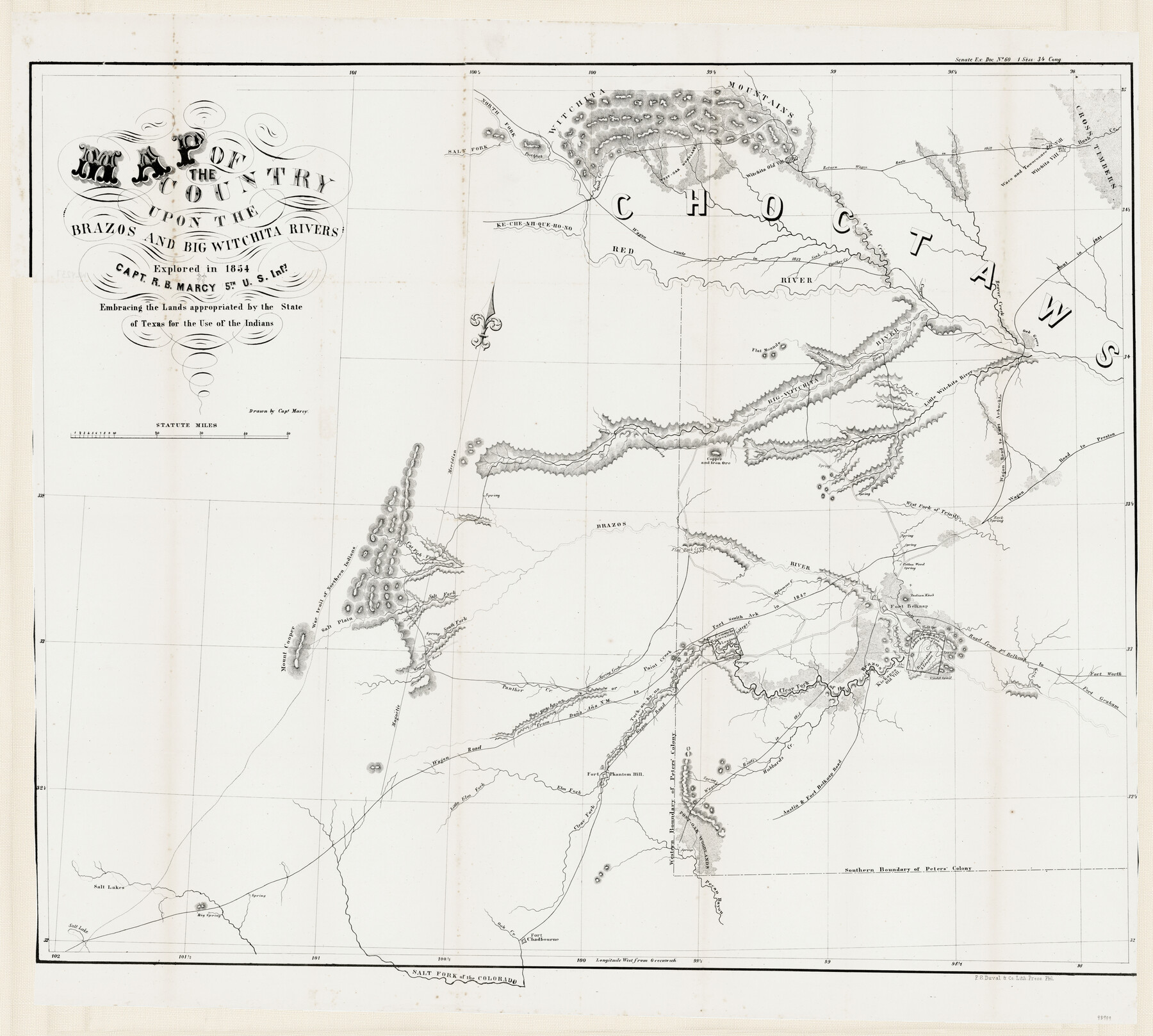
Map of the Country upon the Brazos and Big Witchita Rivers Explored in 1854 by Capt. R.B. Marcy 5th U.S. Infy. Embracing the Lands appropriated by the State of Texas for the Use of the Indians
-
Map/Doc
93999
-
Collection
General Map Collection
-
Object Dates
1854
-
People and Organizations
P.S. Duval & Co. Lith. Press (Printer)
R.B. Marcy (Draftsman)
-
Subjects
Military
-
Height x Width
29.6 x 33.8 inches
75.2 x 85.9 cm
-
Medium
paper
-
Features
South Fork of the Brazos River
Fort Belknap Road
Austin Road
Austin & Fort Belknap Road
Kechi Creek
Tock an ho no
Paint Creek
Qua qua ho no Creek
Qua qua ho no or Paint Creek
Mount Cooper
Hubbard's Creek
Panther Creek
Spring Creek
Stems Farm
Comanche Reservation
Clear Fork of the Brazos River
Kickapoo Old Village
Cadd [sic] Trail
Caddo's Reservation
Fort Chadbourne
Kecheahquehono River
Wagon Route in 1851
Wagon Road
Salt Plain
Sibley's Creek
Salt Fork of the Colorado River
Southern Boundary of Peter's Colony
Pecan Bayou
Salt Creek
Oak Creek
Big Spring
Salt Lakes
Salt Lake
Little Elm Fork [of the Brazos River]
Elm Fork [of the Brazos River]
Fort Phantom Hill
Western Boundary of Peter's Colony
Red River
Pecan Creek
Big Wichita River
Flat Mounds
Large Spring
Copper Creek
Beaver Creek
Rout [sic] in 1831
Cashe Creek
Sink Creek
Little Wichita River
Kecheahquehono or Red River
Otter Creek
Wichita Village
Waco & Towocoonee Village
Rush Creek
Return wagon route in 1852
Wichita Mountains
Salt Fork of the Red River
Salt Fork [of the Brazos River]
Salt Spring
Road from Fort Balknap to Fort Graham
Road from Fort Belknap to Fort Worth
Fort Belknap
Indian Knob
Cotton Wood Spring
Ketumsee Creek
Flat Rock Creek
North Fork of the Red River
Cat Fish Fork [of the Brazos River]
War trail of Northern Indians
Brazos River
Copper & Iron Ore
Rock Spring
West Fork of Trinity River
Wagon Road to Preston
Wagon Road to Fort Arbuckle
Part of: General Map Collection
Hudspeth County Rolled Sketch 78

Print $20.00
- Digital $50.00
Hudspeth County Rolled Sketch 78
2010
Size 18.4 x 24.5 inches
Map/Doc 93290
Map No. 1 - Rio Bravo del Norte section of boundary between the United States & Mexico agreed upon by the Joint Commission under the Treaty of Guadalupe Hidalgo

Print $20.00
- Digital $50.00
Map No. 1 - Rio Bravo del Norte section of boundary between the United States & Mexico agreed upon by the Joint Commission under the Treaty of Guadalupe Hidalgo
1852
Size 18.2 x 27.2 inches
Map/Doc 72865
A sketch of surveys made on the coast east of Bolivar Point

Print $20.00
- Digital $50.00
A sketch of surveys made on the coast east of Bolivar Point
1841
Size 9.1 x 22.0 inches
Map/Doc 22
Flight Mission No. DQO-8K, Frame 63, Galveston County

Print $20.00
- Digital $50.00
Flight Mission No. DQO-8K, Frame 63, Galveston County
1952
Size 18.6 x 22.3 inches
Map/Doc 85167
Hockley County Sketch File 19b

Print $28.00
- Digital $50.00
Hockley County Sketch File 19b
Size 11.3 x 8.8 inches
Map/Doc 26555
Cottle County Sketch File 6a

Print $8.00
- Digital $50.00
Cottle County Sketch File 6a
Size 8.6 x 7.3 inches
Map/Doc 19476
Denton County Sketch File 25

Print $4.00
- Digital $50.00
Denton County Sketch File 25
1863
Size 8.0 x 7.4 inches
Map/Doc 20752
Rail Road Map of the Southern States shewing the Southern & Southwestern Railway Connections with Philadelphia

Print $40.00
- Digital $50.00
Rail Road Map of the Southern States shewing the Southern & Southwestern Railway Connections with Philadelphia
1862
Size 31.6 x 54.1 inches
Map/Doc 97482
Map of Red River County

Print $20.00
- Digital $50.00
Map of Red River County
1872
Size 21.6 x 17.7 inches
Map/Doc 3979
Jasper County Rolled Sketch 6

Print $20.00
- Digital $50.00
Jasper County Rolled Sketch 6
1948
Size 27.8 x 43.7 inches
Map/Doc 6353
Parker County Rolled Sketch 6

Print $20.00
- Digital $50.00
Parker County Rolled Sketch 6
Size 28.3 x 34.1 inches
Map/Doc 7207

You may also like
Ochiltree County Working Sketch 7

Print $40.00
- Digital $50.00
Ochiltree County Working Sketch 7
1968
Size 26.8 x 56.6 inches
Map/Doc 71320
Hardeman County Sketch File 31

Print $4.00
- Digital $50.00
Hardeman County Sketch File 31
Size 14.5 x 9.0 inches
Map/Doc 25066
Primera parte del Mapa, que comprende la Frontera, de los Dominios del Rey, en la America Septentrional

Print $40.00
- Digital $50.00
Primera parte del Mapa, que comprende la Frontera, de los Dominios del Rey, en la America Septentrional
1769
Size 25.8 x 63.2 inches
Map/Doc 3062
Garza County Rolled Sketch R3

Print $20.00
- Digital $50.00
Garza County Rolled Sketch R3
Size 21.4 x 14.9 inches
Map/Doc 6006
Midland County, Texas

Print $20.00
- Digital $50.00
Midland County, Texas
1880
Size 25.5 x 21.5 inches
Map/Doc 740
Terrell County Working Sketch 77

Print $20.00
- Digital $50.00
Terrell County Working Sketch 77
1983
Size 22.9 x 33.7 inches
Map/Doc 69598
Flight Mission No. DQO-7K, Frame 110, Galveston County

Print $20.00
- Digital $50.00
Flight Mission No. DQO-7K, Frame 110, Galveston County
1952
Size 18.7 x 22.3 inches
Map/Doc 85125
Current Miscellaneous File 78

Print $22.00
- Digital $50.00
Current Miscellaneous File 78
1954
Size 10.7 x 8.4 inches
Map/Doc 74199
Montague County Working Sketch 33

Print $20.00
- Digital $50.00
Montague County Working Sketch 33
1976
Size 30.6 x 43.3 inches
Map/Doc 71099
Hartley County

Print $20.00
- Digital $50.00
Hartley County
1891
Size 25.9 x 27.8 inches
Map/Doc 3639
Tom Green County Sketch File 89

Print $4.00
Tom Green County Sketch File 89
Size 14.3 x 8.9 inches
Map/Doc 97245
Brewster County Working Sketch 105

Print $40.00
- Digital $50.00
Brewster County Working Sketch 105
1980
Size 42.5 x 77.6 inches
Map/Doc 67705