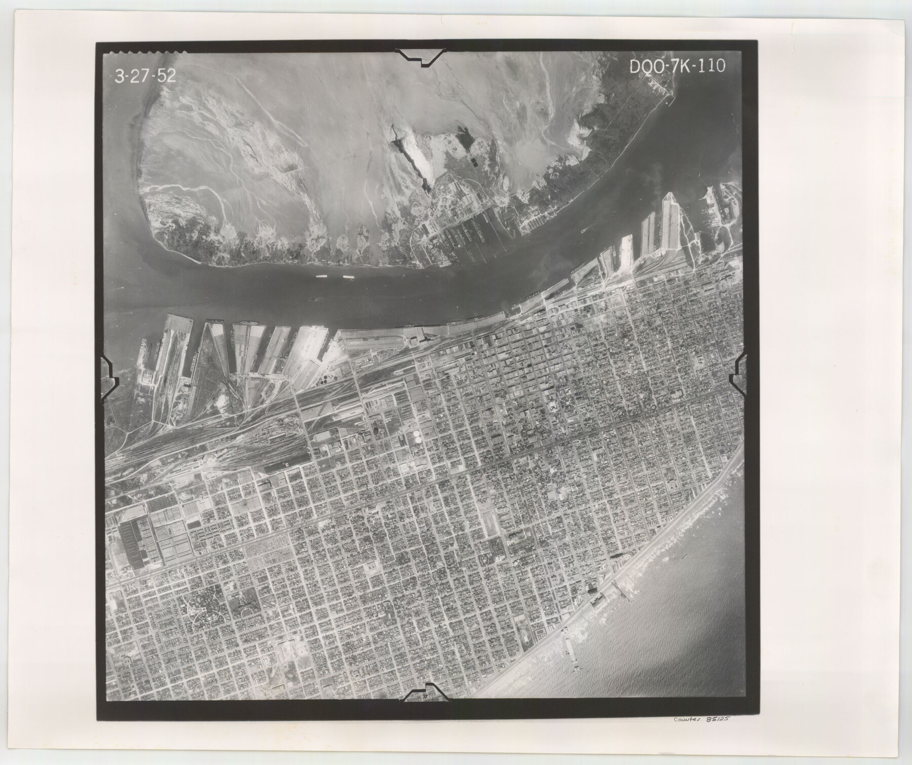
Flight Mission No. DQO-7K, Frame 110, Galveston County
DQO-7K-110
-
Map/Doc
85125
-
Collection
General Map Collection
-
Object Dates
1952/3/27 (Creation Date)
-
People and Organizations
U. S. Department of Agriculture (Publisher)
-
Counties
Galveston
-
Subjects
Aerial Photograph
-
Height x Width
18.7 x 22.3 inches
47.5 x 56.6 cm
-
Comments
Flown by Aero Exploration Company of Tulsa, Oklahoma.
Part of: General Map Collection
Cottle County

Print $20.00
- Digital $50.00
Cottle County
1971
Size 43.4 x 36.0 inches
Map/Doc 95467
Flight Mission No. BRA-8M, Frame 133, Jefferson County

Print $20.00
- Digital $50.00
Flight Mission No. BRA-8M, Frame 133, Jefferson County
1953
Size 18.7 x 22.3 inches
Map/Doc 85629
Shackelford County Working Sketch 5

Print $20.00
- Digital $50.00
Shackelford County Working Sketch 5
1936
Size 22.5 x 31.6 inches
Map/Doc 63845
Map of Orange County

Print $20.00
- Digital $50.00
Map of Orange County
1862
Size 13.6 x 16.5 inches
Map/Doc 3929
Angelina County Sketch File 5

Print $6.00
- Digital $50.00
Angelina County Sketch File 5
1854
Size 8.6 x 6.6 inches
Map/Doc 12928
[Surveys in the Robertson District along the Trinity River and Richland Creek]
![104, [Surveys in the Robertson District along the Trinity River and Richland Creek], General Map Collection](https://historictexasmaps.com/wmedia_w700/maps/104.tif.jpg)
Print $20.00
- Digital $50.00
[Surveys in the Robertson District along the Trinity River and Richland Creek]
1841
Size 15.3 x 12.2 inches
Map/Doc 104
Sutton County Sketch File 26

Print $20.00
- Digital $50.00
Sutton County Sketch File 26
1929
Size 19.6 x 14.8 inches
Map/Doc 12383
Mason County Working Sketch 4

Print $20.00
- Digital $50.00
Mason County Working Sketch 4
1932
Size 16.6 x 22.2 inches
Map/Doc 70840
Concho County Boundary File 2

Print $30.00
- Digital $50.00
Concho County Boundary File 2
Size 12.7 x 8.3 inches
Map/Doc 51814
Bosque County Working Sketch 32

Print $20.00
- Digital $50.00
Bosque County Working Sketch 32
2014
Size 24.3 x 24.7 inches
Map/Doc 93687
Garza County Rolled Sketch 3

Print $20.00
- Digital $50.00
Garza County Rolled Sketch 3
1900
Size 32.7 x 47.7 inches
Map/Doc 75937
Edwards County Sketch File 37

Print $4.00
- Digital $50.00
Edwards County Sketch File 37
1926
Size 11.3 x 9.0 inches
Map/Doc 21771
You may also like
Kendall County Working Sketch 22

Print $20.00
- Digital $50.00
Kendall County Working Sketch 22
1971
Size 41.6 x 34.7 inches
Map/Doc 66694
Montgomery County Sketch File 7

Print $35.00
- Digital $50.00
Montgomery County Sketch File 7
1861
Size 8.8 x 7.8 inches
Map/Doc 31785
Baylor County Boundary File 6

Print $82.00
- Digital $50.00
Baylor County Boundary File 6
Size 9.5 x 65.3 inches
Map/Doc 50400
Crockett County Working Sketch 72

Print $20.00
- Digital $50.00
Crockett County Working Sketch 72
1963
Size 43.9 x 38.5 inches
Map/Doc 68405
Flight Mission No. DAG-28K, Frame 32, Matagorda County

Print $20.00
- Digital $50.00
Flight Mission No. DAG-28K, Frame 32, Matagorda County
1953
Size 16.2 x 16.0 inches
Map/Doc 86600
[John H. Stephens Blk. S-2, Capitol Lgs. to North and County School to the South]
![90241, [John H. Stephens Blk. S-2, Capitol Lgs. to North and County School to the South], Twichell Survey Records](https://historictexasmaps.com/wmedia_w700/maps/90241-1.tif.jpg)
Print $20.00
- Digital $50.00
[John H. Stephens Blk. S-2, Capitol Lgs. to North and County School to the South]
1903
Size 20.7 x 18.3 inches
Map/Doc 90241
Cass County Working Sketch 53

Print $20.00
- Digital $50.00
Cass County Working Sketch 53
2007
Size 30.2 x 36.0 inches
Map/Doc 88608
Improving Sabine Pass, Texas. Surveyed May 10th to June 30th, 1894 under the direction of Major James B. Quinn, Corps of Engineers, USA

Print $20.00
- Digital $50.00
Improving Sabine Pass, Texas. Surveyed May 10th to June 30th, 1894 under the direction of Major James B. Quinn, Corps of Engineers, USA
1894
Size 9.3 x 13.2 inches
Map/Doc 94155
McKinney Bayou Sheet, Bowie County, Red River

Print $20.00
- Digital $50.00
McKinney Bayou Sheet, Bowie County, Red River
1933
Size 37.1 x 33.5 inches
Map/Doc 75272
[Sketch Showing Blocks in Hansford County, Texas]
![75819, [Sketch Showing Blocks in Hansford County, Texas], Maddox Collection](https://historictexasmaps.com/wmedia_w700/maps/75819.tif.jpg)
Print $20.00
- Digital $50.00
[Sketch Showing Blocks in Hansford County, Texas]
1890
Size 34.1 x 25.3 inches
Map/Doc 75819
[Sketch showing San Augustine, Morris, Stephens and Eastland School Land Leagues and adjacent Blocks]
![89918, [Sketch showing San Augustine, Morris, Stephens and Eastland School Land Leagues and adjacent Blocks], Twichell Survey Records](https://historictexasmaps.com/wmedia_w700/maps/89918-1.tif.jpg)
Print $40.00
- Digital $50.00
[Sketch showing San Augustine, Morris, Stephens and Eastland School Land Leagues and adjacent Blocks]
Size 54.7 x 43.5 inches
Map/Doc 89918
Map of Haskell County Young District

Print $20.00
- Digital $50.00
Map of Haskell County Young District
1859
Size 21.9 x 25.8 inches
Map/Doc 3641