Hudspeth County Rolled Sketch 78
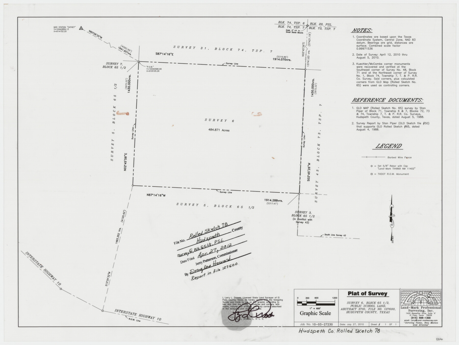
Plat of survey - survey 6, Block 65 1/2, Public School Land, abstract 3710, file no. 127600, Hudspeth County, Texas
-
Map/Doc
93290
-
Collection
General Map Collection
-
Object Dates
2010/7/27 (Creation Date)
2012/4/27 (File Date)
-
People and Organizations
Larry L. Drewes (Surveyor/Engineer)
-
Counties
Hudspeth
-
Subjects
Surveying Rolled Sketch
-
Height x Width
18.4 x 24.5 inches
46.7 x 62.2 cm
-
Medium
mylar, print
-
Scale
1" = 600 feet
-
Comments
See report in School File 127600.
Part of: General Map Collection
Angelina County Sketch File 11d

Print $6.00
- Digital $50.00
Angelina County Sketch File 11d
1885
Size 12.7 x 8.3 inches
Map/Doc 12948
Brazoria County NRC Article 33.136 Sketch 10

Print $23.00
- Digital $50.00
Brazoria County NRC Article 33.136 Sketch 10
2007
Size 25.7 x 35.7 inches
Map/Doc 87933
Atlantic Coast to the Rocky Mountains

Atlantic Coast to the Rocky Mountains
1956
Size 42.5 x 29.4 inches
Map/Doc 94409
Tom Green County Rolled Sketch 12A

Print $40.00
- Digital $50.00
Tom Green County Rolled Sketch 12A
1951
Size 42.9 x 50.4 inches
Map/Doc 10003
La Salle County Rolled Sketch 21

Print $77.00
- Digital $50.00
La Salle County Rolled Sketch 21
1955
Size 10.0 x 15.1 inches
Map/Doc 46461
Donley County Boundary File 7

Print $31.00
- Digital $50.00
Donley County Boundary File 7
Size 11.3 x 8.6 inches
Map/Doc 52640
Flight Mission No. DQN-3K, Frame 33, Calhoun County

Print $20.00
- Digital $50.00
Flight Mission No. DQN-3K, Frame 33, Calhoun County
1953
Size 18.6 x 22.3 inches
Map/Doc 84346
Sterling County Rolled Sketch 24

Print $20.00
- Digital $50.00
Sterling County Rolled Sketch 24
Size 25.8 x 19.6 inches
Map/Doc 7850
Hardin County Working Sketch 36

Print $40.00
- Digital $50.00
Hardin County Working Sketch 36
1981
Size 76.8 x 37.5 inches
Map/Doc 63434
Brewster County Working Sketch 109

Print $20.00
- Digital $50.00
Brewster County Working Sketch 109
1981
Size 25.2 x 37.0 inches
Map/Doc 67709
Flight Mission No. DQN-5K, Frame 60, Calhoun County

Print $20.00
- Digital $50.00
Flight Mission No. DQN-5K, Frame 60, Calhoun County
1953
Size 15.5 x 15.4 inches
Map/Doc 84403
Hidalgo County Rolled Sketch 17

Print $40.00
- Digital $50.00
Hidalgo County Rolled Sketch 17
1963
Size 68.4 x 42.9 inches
Map/Doc 9172
You may also like
Live Oak County Rolled Sketch 6

Print $20.00
- Digital $50.00
Live Oak County Rolled Sketch 6
1947
Size 43.6 x 25.9 inches
Map/Doc 6634
General Highway Map, Clay County, Texas

Print $20.00
General Highway Map, Clay County, Texas
1940
Size 25.2 x 18.6 inches
Map/Doc 79047
Smith County Rolled Sketch 6A3

Print $40.00
- Digital $50.00
Smith County Rolled Sketch 6A3
1990
Size 48.6 x 36.8 inches
Map/Doc 10698
Sutton County Rolled Sketch 53

Print $20.00
- Digital $50.00
Sutton County Rolled Sketch 53
1952
Size 23.4 x 15.5 inches
Map/Doc 7893
Packery Channel

Print $20.00
- Digital $50.00
Packery Channel
1975
Size 18.6 x 46.2 inches
Map/Doc 3004
Brewster County Working Sketch 106

Print $20.00
- Digital $50.00
Brewster County Working Sketch 106
1980
Size 43.3 x 31.8 inches
Map/Doc 67706
Jefferson County Aerial Photograph Index Sheet 7

Print $20.00
- Digital $50.00
Jefferson County Aerial Photograph Index Sheet 7
1953
Size 23.3 x 16.9 inches
Map/Doc 83711
Corpus Christi and Rio Grande Railway Company

Print $20.00
Corpus Christi and Rio Grande Railway Company
Size 14.6 x 24.0 inches
Map/Doc 95314
Flight Mission No. CGI-1N, Frame 179, Cameron County

Print $20.00
- Digital $50.00
Flight Mission No. CGI-1N, Frame 179, Cameron County
1955
Size 18.5 x 22.2 inches
Map/Doc 84514
DeWitt County Working Sketch 6

Print $20.00
- Digital $50.00
DeWitt County Working Sketch 6
1977
Size 30.6 x 26.6 inches
Map/Doc 68596
Glasscock County Sketch File 3

Print $3.00
- Digital $50.00
Glasscock County Sketch File 3
1931
Size 11.1 x 14.8 inches
Map/Doc 11560
Galveston County Sketch File 16

Print $6.00
- Digital $50.00
Galveston County Sketch File 16
Size 7.8 x 6.3 inches
Map/Doc 23384