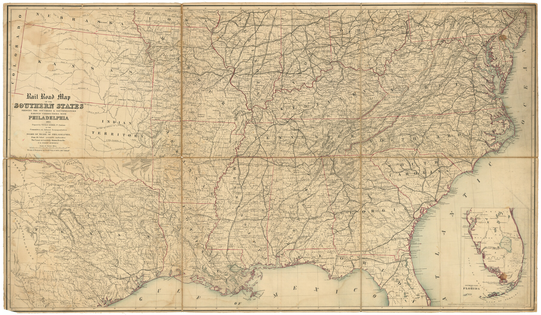
Rail Road Map of the Southern States shewing the Southern & Southwestern Railway Connections with Philadelphia
- 
                          Map/Doc
97482
 - 
                            Collection
General Map Collection
 - 
                            Object Dates
1862 (Creation Date)
 - 
                            People and Organizations
Thomas Kimber, Jr. (Compiler)
P.S. Duval & Son (Engraver)
 - 
                            Subjects
Railroads United States
 - 
                            Height x Width
31.6 x 54.1 inches
80.3 x 137.4 cm
 
Part of: General Map Collection
            Collin County Rolled Sketch 1


                                            Print $20.00                    
                                             -                         Digital $50.00                                    
                Collin County Rolled Sketch 1
1953
Size 34.9 x 35.6 inches
                                Map/Doc 8635
            
            Jeff Davis County Working Sketch 1


                                            Print $20.00                    
                                             -                         Digital $50.00                                    
                Jeff Davis County Working Sketch 1
Size 26.6 x 19.6 inches
                                Map/Doc 66496
            
            Trinity River, Dallas Elevation Sheet


                                            Print $20.00                    
                                             -                         Digital $50.00                                    
                Trinity River, Dallas Elevation Sheet
1913
Size 26.6 x 24.1 inches
                                Map/Doc 65258
            
            Brazoria County Sketch File 30


                                            Print $4.00                    
                                             -                         Digital $50.00                                    
                Brazoria County Sketch File 30
1893
Size 11.1 x 8.7 inches
                                Map/Doc 15037
            
            Dickens County Sketch File 2


                                            Print $20.00                    
                                             -                         Digital $50.00                                    
                Dickens County Sketch File 2
1913
Size 22.0 x 32.3 inches
                                Map/Doc 11316
            
            Texas, Corpus Christi Bay, Mustang Island


                                            Print $40.00                    
                                             -                         Digital $50.00                                    
                Texas, Corpus Christi Bay, Mustang Island
1940
Size 49.2 x 35.8 inches
                                Map/Doc 73461
            
            Newton County Rolled Sketch JFB


                                            Print $20.00                    
                                             -                         Digital $50.00                                    
                Newton County Rolled Sketch JFB
Size 16.0 x 38.3 inches
                                Map/Doc 6858
            
            Montgomery County Rolled Sketch 19A


                                            Print $40.00                    
                                             -                         Digital $50.00                                    
                Montgomery County Rolled Sketch 19A
1933
Size 52.9 x 37.3 inches
                                Map/Doc 8349
            
            [Lower Part of Milam District]


                                            Print $20.00                    
                                             -                         Digital $50.00                                    
                [Lower Part of Milam District]
1850
Size 46.5 x 44.2 inches
                                Map/Doc 1961
            
            Brewster County Rolled Sketch 113


                                            Print $171.00                    
                                             -                         Digital $50.00                                    
                Brewster County Rolled Sketch 113
1975
Map/Doc 9565
            
            McMullen County Working Sketch 54


                                            Print $20.00                    
                                             -                         Digital $50.00                                    
                McMullen County Working Sketch 54
1983
Size 25.3 x 29.0 inches
                                Map/Doc 70755
            
            Glasscock County Working Sketch 6


                                            Print $20.00                    
                                             -                         Digital $50.00                                    
                Glasscock County Working Sketch 6
1945
Size 22.0 x 22.9 inches
                                Map/Doc 63179
            You may also like
            Childress County Sketch File 16


                                            Print $8.00                    
                                             -                         Digital $50.00                                    
                Childress County Sketch File 16
1888
Size 13.9 x 8.5 inches
                                Map/Doc 18282
            
            Cherokee County Working Sketch 2


                                            Print $20.00                    
                                             -                         Digital $50.00                                    
                Cherokee County Working Sketch 2
1932
Size 40.8 x 35.9 inches
                                Map/Doc 67957
            
            Upton County Sketch File 2


                                            Print $40.00                    
                                             -                         Digital $50.00                                    
                Upton County Sketch File 2
Size 38.5 x 55.4 inches
                                Map/Doc 10413
            
            Flight Mission No. CLL-3N, Frame 45, Willacy County


                                            Print $20.00                    
                                             -                         Digital $50.00                                    
                Flight Mission No. CLL-3N, Frame 45, Willacy County
1954
Size 18.4 x 22.1 inches
                                Map/Doc 87103
            
            Flight Mission No. BRA-16M, Frame 66, Jefferson County


                                            Print $20.00                    
                                             -                         Digital $50.00                                    
                Flight Mission No. BRA-16M, Frame 66, Jefferson County
1953
Size 18.6 x 22.3 inches
                                Map/Doc 85683
            
            Williamson County Boundary File 2


                                            Print $40.00                    
                                             -                         Digital $50.00                                    
                Williamson County Boundary File 2
Size 9.0 x 4.2 inches
                                Map/Doc 59992
            
            Town of Wellman Situated on Parts of the Northeast 1/4 and Northwest 1/4 Section 17, Block DD


                                            Print $20.00                    
                                             -                         Digital $50.00                                    
                Town of Wellman Situated on Parts of the Northeast 1/4 and Northwest 1/4 Section 17, Block DD
1924
Size 14.3 x 12.3 inches
                                Map/Doc 92886
            
            Flight Mission No. DQN-3K, Frame 12, Calhoun County


                                            Print $20.00                    
                                             -                         Digital $50.00                                    
                Flight Mission No. DQN-3K, Frame 12, Calhoun County
1953
Size 18.8 x 22.4 inches
                                Map/Doc 84344
            
            Brazoria County Sketch File 3


                                            Print $46.00                    
                                             -                         Digital $50.00                                    
                Brazoria County Sketch File 3
Size 13.1 x 9.4 inches
                                Map/Doc 14923
            
            [T. & P. "B" Blocks, Tsp. 1S, Tsp. 2S, Tsp. 3S. And Tsp. 4S]


                                            Print $40.00                    
                                             -                         Digital $50.00                                    
                [T. & P. "B" Blocks, Tsp. 1S, Tsp. 2S, Tsp. 3S. And Tsp. 4S]
Size 56.1 x 43.3 inches
                                Map/Doc 89774
            
            Brewster County Rolled Sketch 114


                                            Print $20.00                    
                                             -                         Digital $50.00                                    
                Brewster County Rolled Sketch 114
1964
Size 11.4 x 17.7 inches
                                Map/Doc 5284
            
            Clay County Sketch File 44


                                            Print $20.00                    
                                             -                         Digital $50.00                                    
                Clay County Sketch File 44
Size 24.7 x 36.0 inches
                                Map/Doc 11096