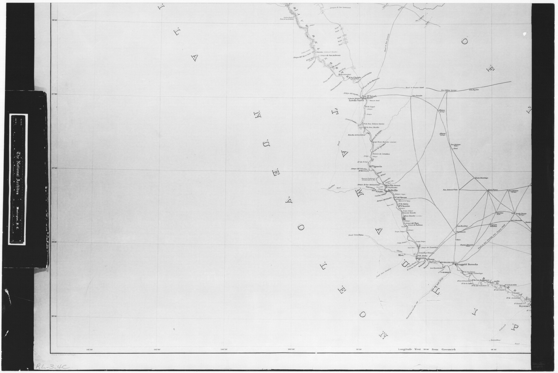
Map No. 1 - Rio Bravo del Norte section of boundary between the United States & Mexico agreed upon by the Joint Commission under the Treaty of Guadalupe Hidalgo
RL-3-4c
-
Map/Doc
72865
-
Collection
General Map Collection
-
Object Dates
1852 - 1853 (Creation Date)
-
People and Organizations
Department of the Interior (Publisher)
Corps of Topographical Engineers (Author)
W.H. Emory (Surveyor/Engineer)
-
Subjects
Texas Boundaries
-
Height x Width
18.2 x 27.2 inches
46.2 x 69.1 cm
-
Comments
B/W photostat copy from National Archives in multiple pieces.
Part of: General Map Collection
Flight Mission No. CLL-3N, Frame 16, Willacy County

Print $20.00
- Digital $50.00
Flight Mission No. CLL-3N, Frame 16, Willacy County
1954
Size 18.5 x 22.1 inches
Map/Doc 87082
Flight Mission No. CRC-3R, Frame 167, Chambers County

Print $20.00
- Digital $50.00
Flight Mission No. CRC-3R, Frame 167, Chambers County
1956
Size 18.7 x 22.3 inches
Map/Doc 84849
Zapata County Sketch File 4

Print $22.00
- Digital $50.00
Zapata County Sketch File 4
1892
Size 14.5 x 17.5 inches
Map/Doc 40906
Menard County Rolled Sketch 15

Print $20.00
- Digital $50.00
Menard County Rolled Sketch 15
1983
Size 27.9 x 22.0 inches
Map/Doc 6761
Reeves County Working Sketch 36

Print $20.00
- Digital $50.00
Reeves County Working Sketch 36
1970
Size 43.1 x 35.0 inches
Map/Doc 63479
Houston County Sketch File 6

Print $4.00
- Digital $50.00
Houston County Sketch File 6
1857
Size 12.0 x 4.7 inches
Map/Doc 26760
Hamilton County Sketch File C

Print $6.00
- Digital $50.00
Hamilton County Sketch File C
Size 12.4 x 11.0 inches
Map/Doc 24950
Hidalgo County Working Sketch 2

Print $20.00
- Digital $50.00
Hidalgo County Working Sketch 2
1906
Size 22.0 x 28.0 inches
Map/Doc 66179

Rusk County Working Sketch 36

Print $20.00
- Digital $50.00
Rusk County Working Sketch 36
2007
Size 31.7 x 36.0 inches
Map/Doc 83786
Flight Mission No. DQN-2K, Frame 188, Calhoun County

Print $20.00
- Digital $50.00
Flight Mission No. DQN-2K, Frame 188, Calhoun County
1953
Size 18.6 x 22.3 inches
Map/Doc 84329
Map of the County of Nueces

Print $20.00
- Digital $50.00
Map of the County of Nueces
1859
Size 39.3 x 39.6 inches
Map/Doc 78391
You may also like
Kendall County Rolled Sketch 5

Print $20.00
- Digital $50.00
Kendall County Rolled Sketch 5
Size 23.4 x 19.3 inches
Map/Doc 6458
Trinity River, Levee Improvement Districts, Widths of Floodways/Pilot Grove Creek and East Fork Trinity River

Print $6.00
- Digital $50.00
Trinity River, Levee Improvement Districts, Widths of Floodways/Pilot Grove Creek and East Fork Trinity River
1920
Size 33.0 x 17.1 inches
Map/Doc 65259
Map of Caldwell County

Print $20.00
- Digital $50.00
Map of Caldwell County
1871
Size 16.9 x 19.9 inches
Map/Doc 4591
Harris County Boundary File 39 (14)

Print $30.00
- Digital $50.00
Harris County Boundary File 39 (14)
Size 13.2 x 8.1 inches
Map/Doc 54344
Map of Fort Bend Co.

Print $20.00
- Digital $50.00
Map of Fort Bend Co.
1898
Size 45.3 x 41.6 inches
Map/Doc 4949
Gulf Intracoastal Waterway, Tex. - Aransas Bay to Corpus Christi Bay - Modified Route of Main Channel/Dredging

Print $20.00
- Digital $50.00
Gulf Intracoastal Waterway, Tex. - Aransas Bay to Corpus Christi Bay - Modified Route of Main Channel/Dredging
1958
Size 30.8 x 42.8 inches
Map/Doc 61896
Gaines County Rolled Sketch 15C

Print $40.00
- Digital $50.00
Gaines County Rolled Sketch 15C
Size 128.4 x 22.8 inches
Map/Doc 75928
Map of Lamar County

Print $20.00
- Digital $50.00
Map of Lamar County
1849
Size 25.7 x 26.8 inches
Map/Doc 1236
Flight Mission No. CRC-5R, Frame 40, Chambers County

Print $20.00
- Digital $50.00
Flight Mission No. CRC-5R, Frame 40, Chambers County
1956
Size 18.6 x 22.4 inches
Map/Doc 84959
Gulf Oil Corp. Fishgide - Port O'Connor

Gulf Oil Corp. Fishgide - Port O'Connor
1960
Size 12.2 x 22.3 inches
Map/Doc 75983
Pecos County Working Sketch 50

Print $20.00
- Digital $50.00
Pecos County Working Sketch 50
1947
Size 21.1 x 13.4 inches
Map/Doc 71522
Sabine Pass and mouth of the River Sabine in the sea

Print $20.00
- Digital $50.00
Sabine Pass and mouth of the River Sabine in the sea
1842
Size 24.0 x 19.1 inches
Map/Doc 93766