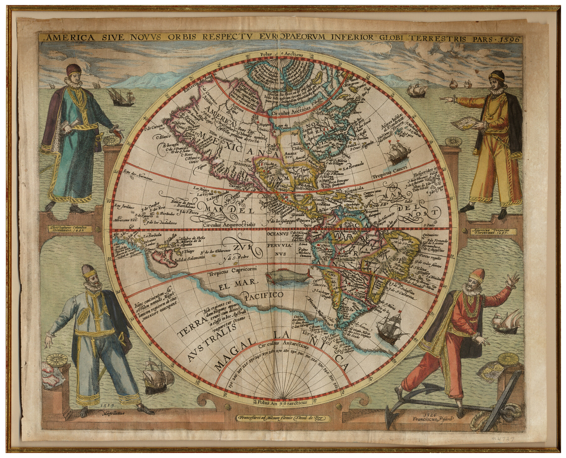
America sive novvs orbis respectv evropaeorvm inferior globi terrestris pars 1596
-
Map/Doc
93809
-
Collection
Holcomb Digital Map Collection
-
Object Dates
1596 (Creation Date)
-
People and Organizations
Theodore de Bry (Author)
-
Subjects
North America South America
-
Height x Width
14.7 x 18.1 inches
37.3 x 46.0 cm
-
Comments
Courtesy of Frank and Carol Holcomb.
Part of: Holcomb Digital Map Collection
Nova Totivs Americae Descriptio

Print $20.00
- Digital $50.00
Nova Totivs Americae Descriptio
1666
Size 21.2 x 24.3 inches
Map/Doc 93818
Map of the Middle States designed to accompany Smith's Geography for Schools

Print $20.00
- Digital $50.00
Map of the Middle States designed to accompany Smith's Geography for Schools
1850
Size 19.4 x 12.2 inches
Map/Doc 93887
Trace d'une partie Chemin de Fer de Galveston à Houston et Henderson, Texas, Etats unis d'Amérique

Print $20.00
- Digital $50.00
Trace d'une partie Chemin de Fer de Galveston à Houston et Henderson, Texas, Etats unis d'Amérique
1857
Size 17.1 x 21.8 inches
Map/Doc 93905
Map of Asia designed to accompany Smith's Geography for Schools

Print $20.00
- Digital $50.00
Map of Asia designed to accompany Smith's Geography for Schools
1850
Size 9.6 x 12.0 inches
Map/Doc 93896
Americae Nova Descriptio

Print $20.00
- Digital $50.00
Americae Nova Descriptio
1652
Size 19.7 x 23.5 inches
Map/Doc 95370
Map of Texas and the Countries Adjacent compiled in the Bureau of the Corps of Topographical Engineers from the Best Authorities

Print $20.00
- Digital $50.00
Map of Texas and the Countries Adjacent compiled in the Bureau of the Corps of Topographical Engineers from the Best Authorities
1844
Size 22.3 x 33.4 inches
Map/Doc 93867
Nuevo Mapa Geographico de la America Septentrional, Perteneciente al Virreynato de Mexico

Print $20.00
- Digital $50.00
Nuevo Mapa Geographico de la America Septentrional, Perteneciente al Virreynato de Mexico
1768
Size 23.1 x 30.3 inches
Map/Doc 93835
A New Map of Texas

Print $20.00
- Digital $50.00
A New Map of Texas
1841
Size 17.6 x 16.2 inches
Map/Doc 93862
Nova et Acurata Totius Americae Tabula

Print $40.00
Nova et Acurata Totius Americae Tabula
1608
Size 40.8 x 56.5 inches
Map/Doc 97019
Americae Sive Novi Orbis Nova Descriptio

Print $20.00
- Digital $50.00
Americae Sive Novi Orbis Nova Descriptio
1606
Size 16.4 x 22.3 inches
Map/Doc 93829
Map of Texas compiled from surveys at the Land Office of Texas

Print $20.00
- Digital $50.00
Map of Texas compiled from surveys at the Land Office of Texas
1851
Size 26.7 x 19.1 inches
Map/Doc 96431
A Map of the Internal Provinces of New Spain

Print $20.00
- Digital $50.00
A Map of the Internal Provinces of New Spain
1807
Size 20.9 x 20.0 inches
Map/Doc 97239
You may also like
Real County Working Sketch 32

Print $20.00
- Digital $50.00
Real County Working Sketch 32
1948
Size 15.6 x 19.6 inches
Map/Doc 71924

Maverick County Sketch File 4

Print $4.00
- Digital $50.00
Maverick County Sketch File 4
1876
Size 9.1 x 8.2 inches
Map/Doc 31051
Bailey County Sketch File 16

Print $8.00
- Digital $50.00
Bailey County Sketch File 16
1941
Size 14.2 x 8.7 inches
Map/Doc 13977
Jefferson County Rolled Sketch 17

Print $40.00
- Digital $50.00
Jefferson County Rolled Sketch 17
1931
Size 18.7 x 72.6 inches
Map/Doc 9281

City of Washington

Print $20.00
- Digital $50.00
City of Washington
1846
Size 14.1 x 18.0 inches
Map/Doc 95358
Uvalde County Working Sketch 41

Print $20.00
- Digital $50.00
Uvalde County Working Sketch 41
1975
Size 15.6 x 27.4 inches
Map/Doc 72111
[Surveys along Seco, Pecan and Deer Creeks]
![316, [Surveys along Seco, Pecan and Deer Creeks], General Map Collection](https://historictexasmaps.com/wmedia_w700/maps/316.tif.jpg)
Print $2.00
- Digital $50.00
[Surveys along Seco, Pecan and Deer Creeks]
1847
Size 8.9 x 7.8 inches
Map/Doc 316
Travis County

Print $40.00
- Digital $50.00
Travis County
1880
Size 59.0 x 70.2 inches
Map/Doc 16902
Brewster County Working Sketch 32

Print $20.00
- Digital $50.00
Brewster County Working Sketch 32
1943
Size 28.3 x 28.3 inches
Map/Doc 67566
St. Louis, Arkansas & Texas R'y, Lufkin Branch, Formerly the Kansas & Gulf Short Line

Print $20.00
- Digital $50.00
St. Louis, Arkansas & Texas R'y, Lufkin Branch, Formerly the Kansas & Gulf Short Line
1888
Size 10.5 x 42.8 inches
Map/Doc 64271