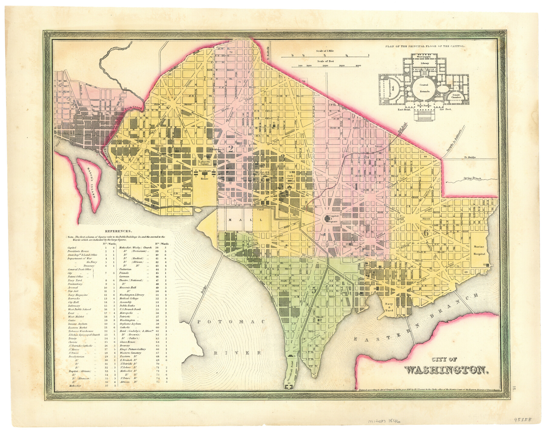
City of Washington
-
Map/Doc
95358
-
Collection
General Map Collection
-
Object Dates
1846 (Creation Date)
1836 (Copyright Date)
-
People and Organizations
H.S. Tanner (Publisher)
S.A. Mitchell, Jr. (Author)
-
Subjects
City
-
Height x Width
14.1 x 18.0 inches
35.8 x 45.7 cm
-
Medium
paper, etching/engraving/lithograph
Part of: General Map Collection
Castro County Sketch File 4j

Print $4.00
- Digital $50.00
Castro County Sketch File 4j
Size 13.5 x 8.7 inches
Map/Doc 17483
Upton County Working Sketch 57

Print $20.00
- Digital $50.00
Upton County Working Sketch 57
1988
Size 28.9 x 37.4 inches
Map/Doc 69554
Tarrant County Boundary File 4 and 4a

Print $6.00
- Digital $50.00
Tarrant County Boundary File 4 and 4a
Size 11.5 x 9.0 inches
Map/Doc 59151
Fannin County Sketch File 11

Print $6.00
- Digital $50.00
Fannin County Sketch File 11
1860
Size 9.9 x 7.4 inches
Map/Doc 22457
Motley County Sketch File B (S)

Print $40.00
- Digital $50.00
Motley County Sketch File B (S)
Size 14.2 x 12.4 inches
Map/Doc 32157
Hardin County Working Sketch 40

Print $20.00
- Digital $50.00
Hardin County Working Sketch 40
1988
Size 23.0 x 14.4 inches
Map/Doc 63439

Map of Motley County

Print $20.00
- Digital $50.00
Map of Motley County
1902
Size 43.4 x 37.7 inches
Map/Doc 10799
National Railways of Mexico

Digital $50.00
National Railways of Mexico
1966
Size 8.9 x 17.6 inches
Map/Doc 94189
Cameron County Boundary File 5

Print $8.00
- Digital $50.00
Cameron County Boundary File 5
Size 8.8 x 15.3 inches
Map/Doc 51113
Burleson County Working Sketch 44

Print $20.00
- Digital $50.00
Burleson County Working Sketch 44
1991
Size 22.4 x 25.0 inches
Map/Doc 67763
Bailey County Sketch File 3a

Print $12.00
- Digital $50.00
Bailey County Sketch File 3a
1901
Size 8.1 x 9.0 inches
Map/Doc 13948
You may also like
Gaines County Sketch

Print $20.00
- Digital $50.00
Gaines County Sketch
Size 9.7 x 18.5 inches
Map/Doc 92668
Panola County Sketch File 22

Print $40.00
- Digital $50.00
Panola County Sketch File 22
Size 15.1 x 16.0 inches
Map/Doc 33492
Uvalde County Working Sketch 17

Print $20.00
- Digital $50.00
Uvalde County Working Sketch 17
1947
Size 27.5 x 37.3 inches
Map/Doc 72087
Current Miscellaneous File 109

Print $9.00
- Digital $50.00
Current Miscellaneous File 109
1967
Size 9.7 x 10.3 inches
Map/Doc 74710
Mapa de los Estados Unidos de Méjico, Segun lo organizado y definido por las varias actas del Congreso de dicha Republica: y construido por las mejores autoridades

Print $20.00
Mapa de los Estados Unidos de Méjico, Segun lo organizado y definido por las varias actas del Congreso de dicha Republica: y construido por las mejores autoridades
1828
Size 29.3 x 41.6 inches
Map/Doc 76217
Map of section no. 9 of a survey of Padre Island made for the Office of the Attorney General of the State of Texas

Print $40.00
- Digital $50.00
Map of section no. 9 of a survey of Padre Island made for the Office of the Attorney General of the State of Texas
1941
Size 58.3 x 42.5 inches
Map/Doc 2265
General Highway Map, Hunt County, Texas

Print $20.00
General Highway Map, Hunt County, Texas
1940
Size 25.0 x 18.5 inches
Map/Doc 79136
Brooks County Sketch File 7

Print $10.00
- Digital $50.00
Brooks County Sketch File 7
1946
Size 11.3 x 8.6 inches
Map/Doc 16566
Amistad International Reservoir on Rio Grande 70

Print $20.00
- Digital $50.00
Amistad International Reservoir on Rio Grande 70
1949
Size 28.4 x 39.7 inches
Map/Doc 73356
Atascosa County Rolled Sketch 17

Print $20.00
- Digital $50.00
Atascosa County Rolled Sketch 17
1953
Size 35.6 x 28.2 inches
Map/Doc 5097

Zapata County Working Sketch 25

Print $40.00
- Digital $50.00
Zapata County Working Sketch 25
2009
Size 36.9 x 71.8 inches
Map/Doc 89051