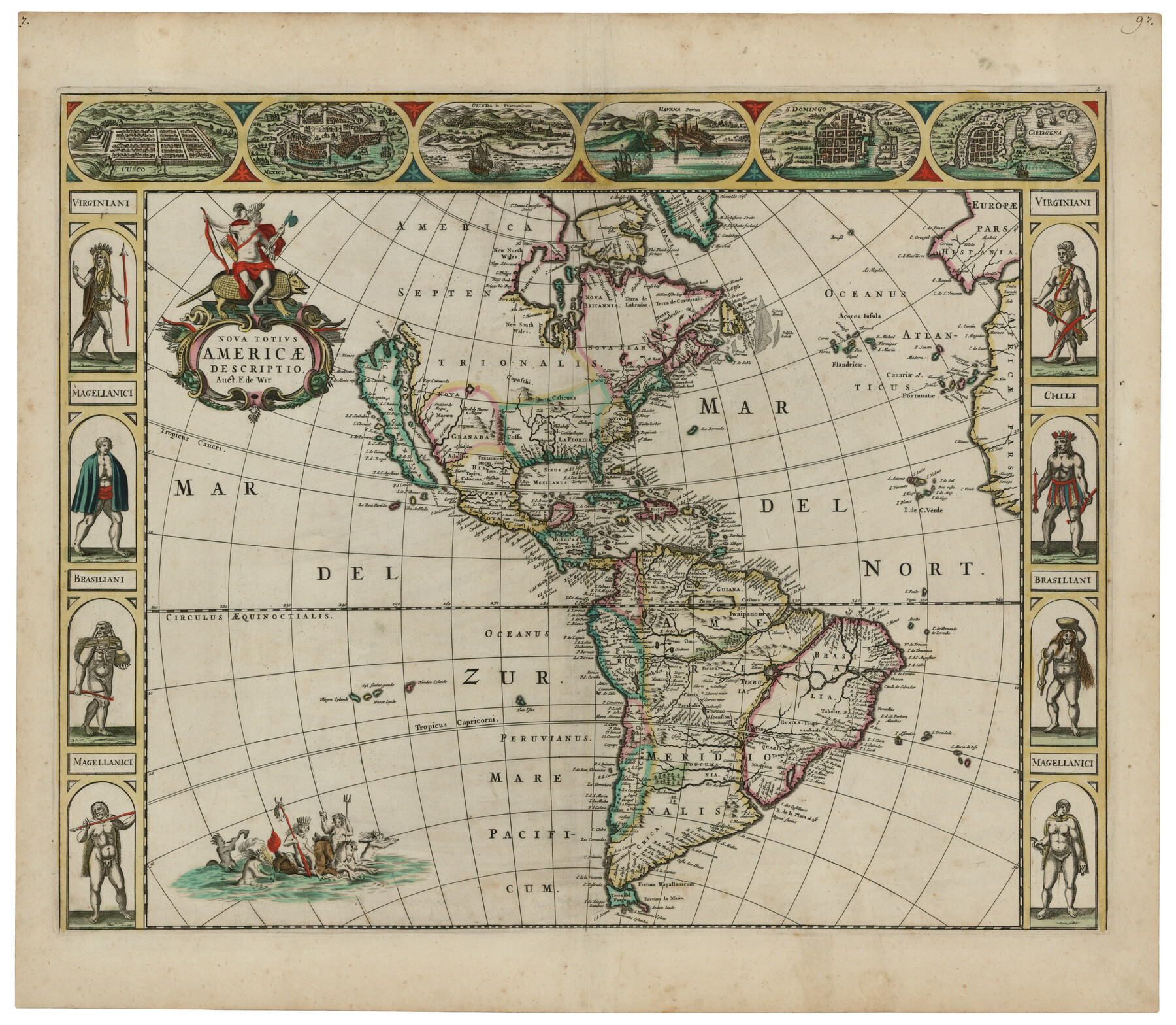
Nova Totivs Americae Descriptio
- 
                          Map/Doc
93818
 - 
                            Collection
Holcomb Digital Map Collection
 - 
                            Object Dates
1666 (Creation Date)
 - 
                            People and Organizations
Frederick de Wit (Publisher)
Frederick de Wit (Author)
 - 
                            Subjects
Central America North America South America
 - 
                            Height x Width
21.2 x 24.3 inches
53.8 x 61.7 cm
 - 
                            Comments
Courtesy of Frank and Carol Holcomb.
 - 
                            URLs
https://medium.com/save-texas-history/terrors-on-the-terra-incognita-ef4d45f57725#.thjpn7q67
 
Part of: Holcomb Digital Map Collection
            A Geographically Correct Map of the State of Texas


                                            Print $20.00                    
                                             -                         Digital $50.00                                    
                A Geographically Correct Map of the State of Texas
1876
Size 19.6 x 21.4 inches
                                Map/Doc 96508
            
            Map of the World: and chart exhibiting the size of each country, nation or kingdom, its population as a whole and to a square mile also the different states of society, forms of government, religion &c.


                                            Print $20.00                    
                                             -                         Digital $50.00                                    
                Map of the World: and chart exhibiting the size of each country, nation or kingdom, its population as a whole and to a square mile also the different states of society, forms of government, religion &c.
1850
Size 12.2 x 19.4 inches
                                Map/Doc 93882
            
            The History of the Republic of Texas, from the discovery of the country to the present time; and the cause of her separation from the Republic of Mexico.


                                            Print $1080.00                    
                                             -                         Digital $50.00                                    
                The History of the Republic of Texas, from the discovery of the country to the present time; and the cause of her separation from the Republic of Mexico.
1842
Size 9.3 x 6.1 inches
                                Map/Doc 93866
            
            Mapa de los Estados Unidos Mejicanos arreglado a la distribucion que en diversos decretos ha hecho del territorio el Congreso General Mejicano


                                            Print $20.00                    
                                             -                         Digital $50.00                                    
                Mapa de los Estados Unidos Mejicanos arreglado a la distribucion que en diversos decretos ha hecho del territorio el Congreso General Mejicano
1837
Size 24.3 x 29.4 inches
                                Map/Doc 96515
            
            Map of the United States of America, the British Provinces, Mexico, the West Indies and Central America with part of New Granada and Venezuela


                                            Print $20.00                    
                                             -                         Digital $50.00                                    
                Map of the United States of America, the British Provinces, Mexico, the West Indies and Central America with part of New Granada and Venezuela
1855
Size 34.7 x 44.0 inches
                                Map/Doc 93904
            
            A new & correct map of Texas compiled from the most recent surveys & authorities to the year 1845


                                            Print $20.00                    
                                             -                         Digital $50.00                                    
                A new & correct map of Texas compiled from the most recent surveys & authorities to the year 1845
1845
Size 22.4 x 28.5 inches
                                Map/Doc 96973
            
            Pressler's Map of the State of Texas


                                            Print $40.00                    
                                             -                         Digital $50.00                                    
                Pressler's Map of the State of Texas
1862
Size 48.0 x 52.7 inches
                                Map/Doc 95714
            
            Map of Europe designed to accompany Smith's Geography for Schools


                                            Print $20.00                    
                                             -                         Digital $50.00                                    
                Map of Europe designed to accompany Smith's Geography for Schools
1850
Size 9.8 x 12.1 inches
                                Map/Doc 93892
            
            Map of Texas and the Countries Adjacent compiled in the Bureau of the Corps of Topographical Engineers from the Best Authorities


                                            Print $2.00                    
                                             -                         Digital $50.00                                    
                Map of Texas and the Countries Adjacent compiled in the Bureau of the Corps of Topographical Engineers from the Best Authorities
1844
Size 8.1 x 5.0 inches
                                Map/Doc 93868
            
            Karte von Texas entworfen nach den Vermessungen welche in den Acten der General-Land-Office der Republick


                                            Print $20.00                    
                                             -                         Digital $50.00                                    
                Karte von Texas entworfen nach den Vermessungen welche in den Acten der General-Land-Office der Republick
1846
Size 16.9 x 17.6 inches
                                Map/Doc 94118
            
            Americae Sive Novi Orbis Nova Descriptio


                                            Print $20.00                    
                                             -                         Digital $50.00                                    
                Americae Sive Novi Orbis Nova Descriptio
1579
Size 18.0 x 22.9 inches
                                Map/Doc 93805
            You may also like
            [T. & P. Block 44, Township 1S]


                                            Print $3.00                    
                                             -                         Digital $50.00                                    
                [T. & P. Block 44, Township 1S]
Size 9.3 x 11.9 inches
                                Map/Doc 90818
            
            Coast Chart No. 210 Aransas Pass and Corpus Christi Bay with the coast to latitude 27° 12' Texas


                                            Print $20.00                    
                                             -                         Digital $50.00                                    
                Coast Chart No. 210 Aransas Pass and Corpus Christi Bay with the coast to latitude 27° 12' Texas
1887
Size 27.3 x 18.2 inches
                                Map/Doc 72792
            
            Donley County Rolled Sketch 3A


                                            Print $20.00                    
                                             -                         Digital $50.00                                    
                Donley County Rolled Sketch 3A
1946
Size 15.2 x 22.6 inches
                                Map/Doc 5730
            
            Flight Mission No. CRC-2R, Frame 193, Chambers County


                                            Print $20.00                    
                                             -                         Digital $50.00                                    
                Flight Mission No. CRC-2R, Frame 193, Chambers County
1956
Size 18.9 x 22.5 inches
                                Map/Doc 84771
            
            Map of part of Matagorda Island


                                            Print $20.00                    
                                             -                         Digital $50.00                                    
                Map of part of Matagorda Island
1859
Size 30.2 x 32.0 inches
                                Map/Doc 69982
            
            Ector County Sketch File 12


                                            Print $12.00                    
                                             -                         Digital $50.00                                    
                Ector County Sketch File 12
1956
Size 11.4 x 9.0 inches
                                Map/Doc 21645
            
            Limestone County Working Sketch 4


                                            Print $20.00                    
                                             -                         Digital $50.00                                    
                Limestone County Working Sketch 4
1921
Size 20.2 x 26.3 inches
                                Map/Doc 70554
            
            Boundary Between the United States & Mexico Agreed upon by the Joint Commission under the Treaty of Guadalupe Hidalgo


                                            Print $20.00                    
                                             -                         Digital $50.00                                    
                Boundary Between the United States & Mexico Agreed upon by the Joint Commission under the Treaty of Guadalupe Hidalgo
1853
Size 18.3 x 26.7 inches
                                Map/Doc 72885
            
            Hutchinson County Rolled Sketch 22


                                            Print $20.00                    
                                             -                         Digital $50.00                                    
                Hutchinson County Rolled Sketch 22
1914
Size 29.3 x 38.0 inches
                                Map/Doc 6287
            
            Bee County Sketch File 24


                                            Print $8.00                    
                                             -                         Digital $50.00                                    
                Bee County Sketch File 24
1879
Size 10.2 x 8.3 inches
                                Map/Doc 14322
            
            Polk County Rolled Sketch 23


                                            Print $20.00                    
                                             -                         Digital $50.00                                    
                Polk County Rolled Sketch 23
Size 29.1 x 23.5 inches
                                Map/Doc 7313
            
            El Paso County Rolled Sketch 38


                                            Print $40.00                    
                                             -                         Digital $50.00                                    
                El Paso County Rolled Sketch 38
1922
Size 14.1 x 61.3 inches
                                Map/Doc 8866