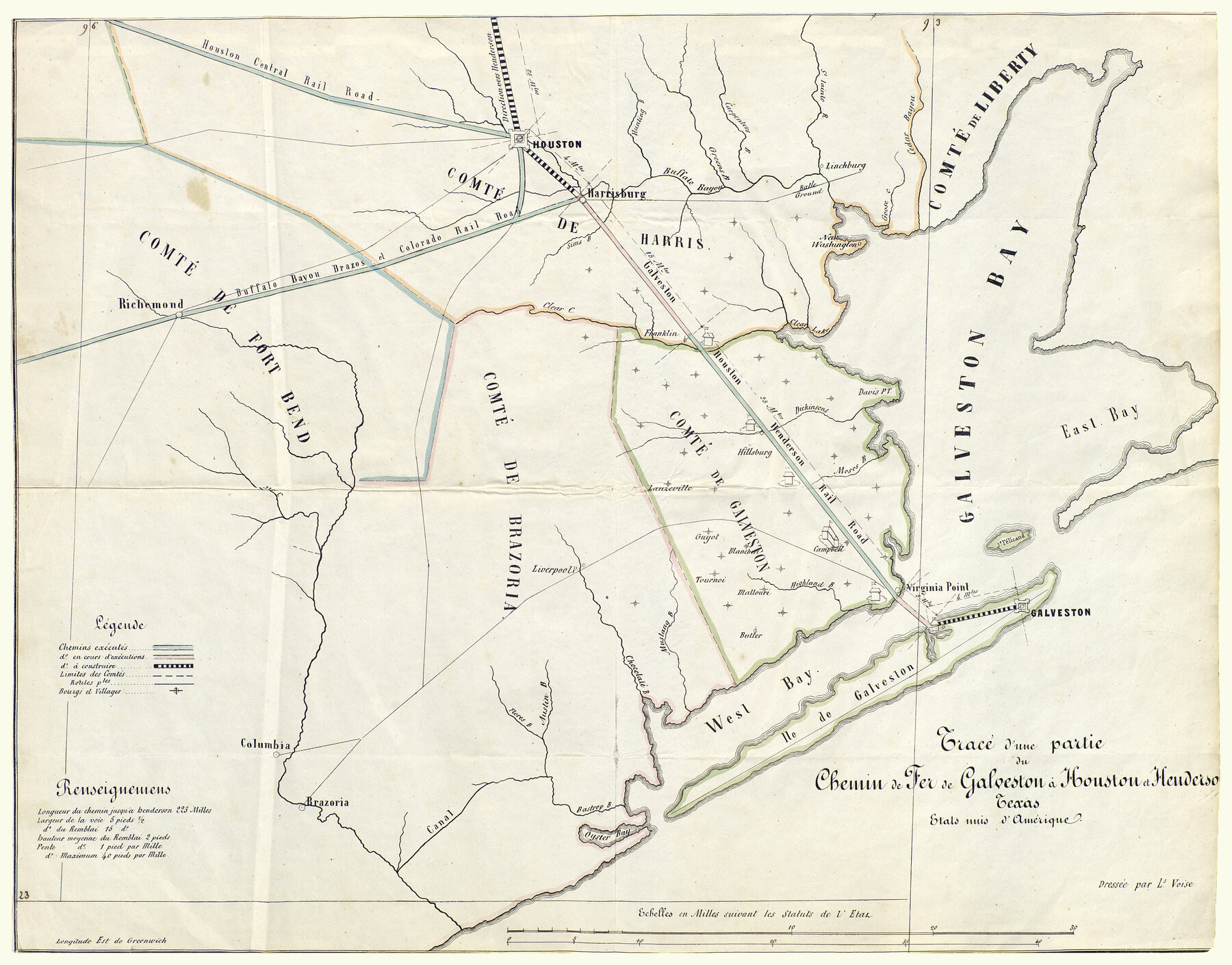
Trace d'une partie Chemin de Fer de Galveston à Houston et Henderson, Texas, Etats unis d'Amérique
-
Map/Doc
93905
-
Collection
Holcomb Digital Map Collection
-
Object Dates
1857 (Creation Date)
-
People and Organizations
Ls. Voise (Draftsman)
-
Subjects
Railroads
-
Height x Width
17.1 x 21.8 inches
43.4 x 55.4 cm
-
Comments
Courtesy of Frank and Carol Holcomb.
-
URLs
https://medium.com/@txglo/7bf96f21a7ba
Part of: Holcomb Digital Map Collection
Map of the United States

Print $20.00
- Digital $50.00
Map of the United States
1851
Size 25.1 x 25.3 inches
Map/Doc 93899
Map of the Southern part of Texas

Print $20.00
- Digital $50.00
Map of the Southern part of Texas
1831
Size 17.5 x 21.3 inches
Map/Doc 94442
The History of Texas; or, the Emigrants, Farmer's, and Politician's Guide to the Character, Climate, Soil and Productions of that Country; geographically arranged from personal observation and experience.

Print $692.00
- Digital $50.00
The History of Texas; or, the Emigrants, Farmer's, and Politician's Guide to the Character, Climate, Soil and Productions of that Country; geographically arranged from personal observation and experience.
1836
Size 8.1 x 5.3 inches
Map/Doc 93856
Americae Nova Descriptio

Print $20.00
- Digital $50.00
Americae Nova Descriptio
1652
Size 19.7 x 23.5 inches
Map/Doc 95370
Smith's Atlas designed to accompany the Geography

Print $352.00
- Digital $50.00
Smith's Atlas designed to accompany the Geography
1850
Size 12.2 x 10.0 inches
Map/Doc 93881
Carte Nouvelle de la Mer du Sud

Print $20.00
- Digital $50.00
Carte Nouvelle de la Mer du Sud
1730
Size 25.8 x 39.6 inches
Map/Doc 93824
Burlington Route

Print $20.00
- Digital $50.00
Burlington Route
1892
Size 34.9 x 47.7 inches
Map/Doc 93910
A Map of Louisiana and Mexico

Print $20.00
- Digital $50.00
A Map of Louisiana and Mexico
1820
Size 43.8 x 32.9 inches
Map/Doc 94945
A new & correct map of Texas compiled from the most recent surveys & authorities to the year 1845

Print $20.00
- Digital $50.00
A new & correct map of Texas compiled from the most recent surveys & authorities to the year 1845
1845
Size 22.4 x 28.5 inches
Map/Doc 96973
Traveller's Map of the State of Texas

Print $20.00
- Digital $50.00
Traveller's Map of the State of Texas
1867
Size 43.4 x 41.6 inches
Map/Doc 93906
Map of Mexico, including Yucatan & Upper California, exhibiting the chief cities and towns, the principal travelling routes &c.

Print $20.00
- Digital $50.00
Map of Mexico, including Yucatan & Upper California, exhibiting the chief cities and towns, the principal travelling routes &c.
1846
Size 18.3 x 26.1 inches
Map/Doc 93871
America with those known parts in that unknowne worlde both people and manner of buildings

Print $20.00
- Digital $50.00
America with those known parts in that unknowne worlde both people and manner of buildings
1626
Size 17.2 x 22.3 inches
Map/Doc 93830
You may also like
Newton County Working Sketch 11

Print $20.00
- Digital $50.00
Newton County Working Sketch 11
1941
Size 22.7 x 23.5 inches
Map/Doc 71257
Waller County Sketch File 11

Print $40.00
- Digital $50.00
Waller County Sketch File 11
1913
Size 16.6 x 14.3 inches
Map/Doc 39614
Blocks 14, 15, and 16, Capitol Syndicate Subdivision of Capitol Land Reservation Leagues

Print $20.00
- Digital $50.00
Blocks 14, 15, and 16, Capitol Syndicate Subdivision of Capitol Land Reservation Leagues
1908
Size 24.6 x 37.1 inches
Map/Doc 90736
Travis County Appraisal District Plat Map 2_0803

Print $20.00
- Digital $50.00
Travis County Appraisal District Plat Map 2_0803
Size 21.5 x 26.4 inches
Map/Doc 94239
Live Oak County Boundary File 9

Print $4.00
- Digital $50.00
Live Oak County Boundary File 9
Size 12.7 x 7.8 inches
Map/Doc 56399
Sketch in Uvalde County

Print $20.00
- Digital $50.00
Sketch in Uvalde County
1890
Size 12.3 x 15.9 inches
Map/Doc 5049
General Highway Map, Midland County, Texas

Print $20.00
General Highway Map, Midland County, Texas
1961
Size 18.2 x 24.6 inches
Map/Doc 79596
Flight Mission No. DQN-2K, Frame 120, Calhoun County

Print $20.00
- Digital $50.00
Flight Mission No. DQN-2K, Frame 120, Calhoun County
1953
Size 18.4 x 16.1 inches
Map/Doc 84296
Grayson County Boundary File 2

Print $14.00
- Digital $50.00
Grayson County Boundary File 2
Size 12.7 x 7.9 inches
Map/Doc 53931
Aransas County Sketch File 35

Print $61.00
- Digital $50.00
Aransas County Sketch File 35
1984
Size 11.0 x 8.8 inches
Map/Doc 13347
Jefferson County Sketch File 9

Print $40.00
- Digital $50.00
Jefferson County Sketch File 9
1860
Size 12.6 x 15.2 inches
Map/Doc 28123
Young County Rolled Sketch 18

Print $20.00
- Digital $50.00
Young County Rolled Sketch 18
2020
Size 22.6 x 30.4 inches
Map/Doc 95960