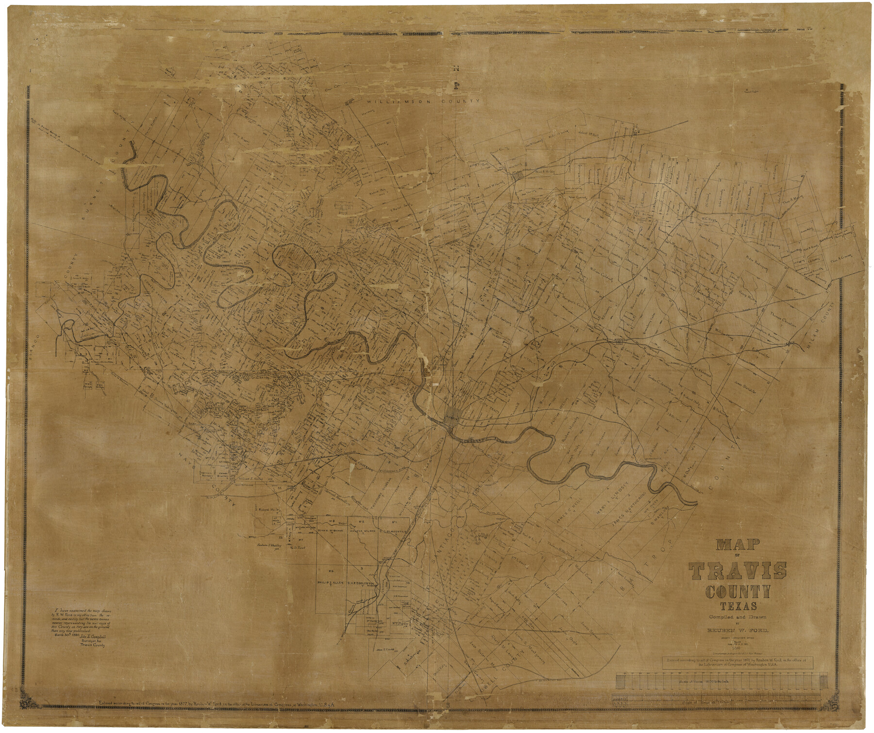
Travis County
-
Map/Doc
16902
-
Collection
General Map Collection
-
Object Dates
1880 (Creation Date)
-
People and Organizations
Reuben W. Ford (Compiler)
Reuben W. Ford (Draftsman)
August Gast & Co. (Lithographer)
-
Counties
Travis
-
Subjects
County
-
Height x Width
59.0 x 70.2 inches
149.9 x 178.3 cm
-
Comments
Map begun in 1877.
Conservation funded in 2004 with donation from Hilgers and Watkins, P. C. and Friends of the Texas General Land Office.
Digitized in 2012 with a generous grant from the Summerlee Foundation. -
Features
Bear Creek
Taylor
Bagdad Post Office
Old San Antonio Road
Saint Elmo Post Office
Fredericksburg Road
Slaughter Creek
Williamson Creek
Mountain City Road
Road to Bastrop
Manchaca School
Onion Creek Post Office
Cross Creek
Pilot Knob
Cedar Creek
Cottonmouth Branch of Onion Creek
Onion Creek
Webberville
Austin
Grape Creek
Spring Creek
Road to Birdtown
Deadman's Creek
Basoner Creek
Public Road to Round Rock and Georgetown
Manchaca Station
[Road] to Mountain City
Road from Fredericksburg
Thomas's Branch
Shrine Creek
Goatman Post Office
Waller Creek
Shoal Creek
Mount Bonnell
Cascade Creek
Honey Creek
Shingle Hills
Shoal Creek
Jourdan House
Phluegerville [sic]
Duval
Falls Creek
Corwin's Mill
Rice's Crossing
Cherry Brush Creek
Newton
Forty Acre Hollow
J. P. Dode's Post Office
Dell Creek
Corwin's Mill Post Office
Red Bank Creek
Flat Creek
Road to Burnet
[Road to] Hutto
[Road] to Taylor
Lake Creek
New Round Rock
Old Round Rock
Road to Georgetown
Anderson's Mill Post Office
Brushy Creek
Cow Creek
Post Oak Creek
Colorado River
Travis Peak Post Office
Cherry Creek
Cherry Hollow Creek
Sandy Creek
Hutto Station Post Office
Bagdad
Spicewood Spring
Bee Cave Post Office
Round Rock Road
Wilbarger Creek
Road to Hogeye
Elgin
Willow Creek
Cottonwood Creek
Manor
Gilleland's Creek
Little Walnut Creek
Fiskville Post Office
Long Hollow Creek
Hurst Creek
Bee Creek
Cypress Creek
Pedernales River
Dessau Settlement
Harris's Branch
[Road to] Rockdale
Elm Creek
Merrilltown Post Office
Jolleville [sic]
Part of: General Map Collection
Tarrant County

Print $20.00
- Digital $50.00
Tarrant County
1942
Size 46.5 x 37.1 inches
Map/Doc 77431
Polk County Rolled Sketch 33

Print $20.00
- Digital $50.00
Polk County Rolled Sketch 33
Size 26.5 x 38.5 inches
Map/Doc 7319
Brazoria County Working Sketch 26

Print $20.00
- Digital $50.00
Brazoria County Working Sketch 26
1968
Size 33.2 x 35.4 inches
Map/Doc 67511
Duval County Sketch File 31

Print $20.00
- Digital $50.00
Duval County Sketch File 31
1932
Size 29.3 x 17.7 inches
Map/Doc 11389
Texas City Channel, Texas, Channel and Turning Basin Dredging - Sheet 4

Print $20.00
- Digital $50.00
Texas City Channel, Texas, Channel and Turning Basin Dredging - Sheet 4
1958
Size 28.5 x 40.9 inches
Map/Doc 61834
Val Verde County Rolled Sketch 44

Print $61.00
- Digital $50.00
Val Verde County Rolled Sketch 44
Size 10.2 x 15.3 inches
Map/Doc 49454
Liberty County Working Sketch 56

Print $40.00
- Digital $50.00
Liberty County Working Sketch 56
1966
Size 52.0 x 28.4 inches
Map/Doc 70516
[Sketch & Field Note Calls of Pecos, Terrell & Val Verde Counties, Texas]
![1720, [Sketch & Field Note Calls of Pecos, Terrell & Val Verde Counties, Texas], General Map Collection](https://historictexasmaps.com/wmedia_w700/pdf_converted_jpg/qi_pdf_thumbnail_734.jpg)
Print $20.00
- Digital $50.00
[Sketch & Field Note Calls of Pecos, Terrell & Val Verde Counties, Texas]
1915
Size 19.4 x 24.2 inches
Map/Doc 1720
Dawson County Sketch File 24

Print $8.00
- Digital $50.00
Dawson County Sketch File 24
Size 12.5 x 8.7 inches
Map/Doc 20577
Val Verde County Sketch File 49

Print $20.00
- Digital $50.00
Val Verde County Sketch File 49
1953
Size 27.1 x 20.2 inches
Map/Doc 12590
Jefferson County Sketch File 8

Print $8.00
- Digital $50.00
Jefferson County Sketch File 8
Size 8.0 x 7.6 inches
Map/Doc 28116
City of Austin, Texas and Suburban Territory

Print $40.00
- Digital $50.00
City of Austin, Texas and Suburban Territory
1952
Size 52.9 x 47.2 inches
Map/Doc 73582
You may also like
Pecos County Sketch File 31 1/2

Print $20.00
- Digital $50.00
Pecos County Sketch File 31 1/2
1931
Size 34.3 x 23.4 inches
Map/Doc 12174
Roberts County

Print $20.00
- Digital $50.00
Roberts County
1900
Size 43.4 x 42.0 inches
Map/Doc 63002
Shelby County Working Sketch 13

Print $40.00
- Digital $50.00
Shelby County Working Sketch 13
1946
Size 52.0 x 33.7 inches
Map/Doc 63866
Zapata County Rolled Sketch 28

Print $20.00
- Digital $50.00
Zapata County Rolled Sketch 28
Size 35.5 x 35.3 inches
Map/Doc 10174
Harris County Sketch File 75

Print $4.00
- Digital $50.00
Harris County Sketch File 75
1948
Size 11.7 x 9.0 inches
Map/Doc 25544
Travis County Working Sketch 18

Print $20.00
- Digital $50.00
Travis County Working Sketch 18
1945
Size 30.4 x 42.9 inches
Map/Doc 69402
Sketch of work done by Erath and Green in August 1846 on the north fork of Cow Bayou

Print $2.00
- Digital $50.00
Sketch of work done by Erath and Green in August 1846 on the north fork of Cow Bayou
1846
Size 9.8 x 7.9 inches
Map/Doc 78373
Brewster County Rolled Sketch 114

Print $20.00
- Digital $50.00
Brewster County Rolled Sketch 114
1964
Size 17.3 x 11.4 inches
Map/Doc 5292
Comanche County Sketch File 22

Print $4.00
- Digital $50.00
Comanche County Sketch File 22
1873
Size 15.2 x 9.2 inches
Map/Doc 19106
Moore County Working Sketch 9

Print $20.00
- Digital $50.00
Moore County Working Sketch 9
1950
Size 38.5 x 31.8 inches
Map/Doc 71191
Montgomery County Working Sketch 1

Print $20.00
- Digital $50.00
Montgomery County Working Sketch 1
1912
Size 20.8 x 17.1 inches
Map/Doc 71107
Dawson County Working Sketch 19

Print $20.00
- Digital $50.00
Dawson County Working Sketch 19
1963
Size 24.8 x 32.4 inches
Map/Doc 68563