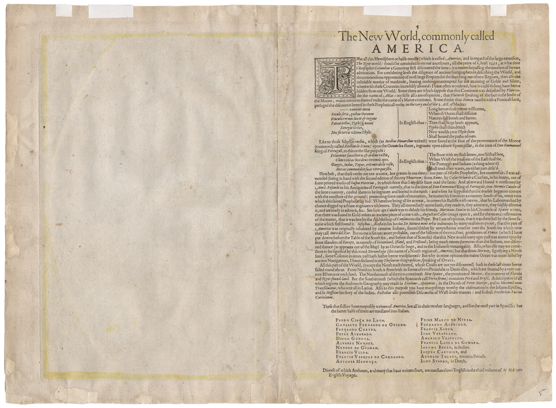
Americae Sive Novi Orbis Nova Descriptio
-
Map/Doc
93829
-
Collection
Holcomb Digital Map Collection
-
Object Dates
1606 (Creation Date)
-
People and Organizations
[John Norton] (Publisher)
[Abraham Ortelius] (Author)
-
Subjects
North America South America
-
Height x Width
16.4 x 22.3 inches
41.7 x 56.6 cm
-
Comments
Courtesy of Frank and Carol Holcomb.
Part of: Holcomb Digital Map Collection
Americae nova Tabula

Print $20.00
- Digital $50.00
Americae nova Tabula
1635
Size 18.4 x 24.3 inches
Map/Doc 93812
Map of Asia designed to accompany Smith's Geography for Schools

Print $20.00
- Digital $50.00
Map of Asia designed to accompany Smith's Geography for Schools
1850
Size 9.6 x 12.0 inches
Map/Doc 93896
Topographisch-geognostische Karte von Texas mit Zugrundelegung der geographischen Karte v. Wilson nach eigenen Beobachtungen bearbeitet von Dr. Ferd. Roemer

Print $20.00
- Digital $50.00
Topographisch-geognostische Karte von Texas mit Zugrundelegung der geographischen Karte v. Wilson nach eigenen Beobachtungen bearbeitet von Dr. Ferd. Roemer
1849
Size 24.5 x 21.0 inches
Map/Doc 94099
A New, Plaine, and Exact map of America : described by N.I. Visscher, and don into English, enlarged, and corrected, according to I. Blaeu, with the habits of the countries, and the manner of the cheife Citties, the like never before

Print $20.00
- Digital $50.00
A New, Plaine, and Exact map of America : described by N.I. Visscher, and don into English, enlarged, and corrected, according to I. Blaeu, with the habits of the countries, and the manner of the cheife Citties, the like never before
1658
Size 16.4 x 20.9 inches
Map/Doc 96787
Map and Description of Texas, containing sketches of its history, geology, geography and statistics: with concise statements, relative to the soil, climate, productions, facilities of transportation, population of the country;

Print $324.00
- Digital $50.00
Map and Description of Texas, containing sketches of its history, geology, geography and statistics: with concise statements, relative to the soil, climate, productions, facilities of transportation, population of the country;
1840
Size 6.1 x 4.1 inches
Map/Doc 93861
Map of Texas compiled from surveys included in the General Land Office

Print $20.00
- Digital $50.00
Map of Texas compiled from surveys included in the General Land Office
1851
Size 31.4 x 25.3 inches
Map/Doc 94417
Map of the Southern States designed to accompany Smith's Geography for Schools

Print $20.00
- Digital $50.00
Map of the Southern States designed to accompany Smith's Geography for Schools
1850
Size 12.1 x 19.2 inches
Map/Doc 93888
Americae Sive Novi Orbis Nova Descriptio

Print $20.00
- Digital $50.00
Americae Sive Novi Orbis Nova Descriptio
1606
Size 16.5 x 22.4 inches
Map/Doc 93810
America Settentrionale Colle Nuoue Scoperte fin all' Anno 1688

Print $20.00
- Digital $50.00
America Settentrionale Colle Nuoue Scoperte fin all' Anno 1688
1688
Size 25.4 x 37.6 inches
Map/Doc 96506
Mapa de los Estados Unidos de Méjico, Segun lo organizado y definido por las varias actas del Congreso de dicha Republica: y construido por las mejores autoridades

Print $20.00
- Digital $50.00
Mapa de los Estados Unidos de Méjico, Segun lo organizado y definido por las varias actas del Congreso de dicha Republica: y construido por las mejores autoridades
1847
Size 31.3 x 42.3 inches
Map/Doc 93878
L'Amerique Meridionale et Septentrionale

Print $20.00
- Digital $50.00
L'Amerique Meridionale et Septentrionale
1731
Size 20.0 x 28.3 inches
Map/Doc 93825
Terre Nove (verso)

Print $20.00
- Digital $50.00
Terre Nove (verso)
1522
Size 12.2 x 7.8 inches
Map/Doc 93802
You may also like
[Plat Showing San Gabriel & 24th Street Intersection, Outlot 4, Travis County, Texas]
![75795, [Plat Showing San Gabriel & 24th Street Intersection, Outlot 4, Travis County, Texas], Maddox Collection](https://historictexasmaps.com/wmedia_w700/maps/75795.tif.jpg)
Print $2.00
- Digital $50.00
[Plat Showing San Gabriel & 24th Street Intersection, Outlot 4, Travis County, Texas]
Size 11.4 x 8.7 inches
Map/Doc 75795
Henderson County Rolled Sketch 12

Print $20.00
- Digital $50.00
Henderson County Rolled Sketch 12
1980
Size 22.8 x 19.1 inches
Map/Doc 6204
University of Texas System University Lands

Print $20.00
- Digital $50.00
University of Texas System University Lands
1972
Size 23.2 x 17.9 inches
Map/Doc 93250
San Saba County Sketch File 5

Print $4.00
- Digital $50.00
San Saba County Sketch File 5
Size 12.8 x 8.0 inches
Map/Doc 36412
Blanco County Working Sketch 33

Print $40.00
- Digital $50.00
Blanco County Working Sketch 33
1978
Size 41.0 x 57.5 inches
Map/Doc 67393
Tyler County Sketch File 31

Print $10.00
- Digital $50.00
Tyler County Sketch File 31
1941
Size 14.3 x 9.0 inches
Map/Doc 38723
[Texas Panhandle North Boundary Line]
![1714, [Texas Panhandle North Boundary Line], General Map Collection](https://historictexasmaps.com/wmedia_w700/maps/1714.tif.jpg)
Print $20.00
- Digital $50.00
[Texas Panhandle North Boundary Line]
1898
Size 43.6 x 11.4 inches
Map/Doc 1714
Travis County Working Sketch 38

Print $20.00
- Digital $50.00
Travis County Working Sketch 38
1974
Size 17.5 x 34.8 inches
Map/Doc 69422
Map of the City of Galveston, Texas

Print $20.00
- Digital $50.00
Map of the City of Galveston, Texas
1904
Size 32.0 x 44.0 inches
Map/Doc 73629
Jefferson County NRC Article 33.136 Sketch 10

Print $28.00
- Digital $50.00
Jefferson County NRC Article 33.136 Sketch 10
2012
Size 24.0 x 36.0 inches
Map/Doc 94575
[Panhandle Counties]
![92066, [Panhandle Counties], Twichell Survey Records](https://historictexasmaps.com/wmedia_w700/maps/92066-1.tif.jpg)
Print $2.00
- Digital $50.00
[Panhandle Counties]
1885
Size 12.6 x 8.9 inches
Map/Doc 92066
Montgomery County Working Sketch 43

Print $20.00
- Digital $50.00
Montgomery County Working Sketch 43
1956
Size 29.9 x 25.9 inches
Map/Doc 71150