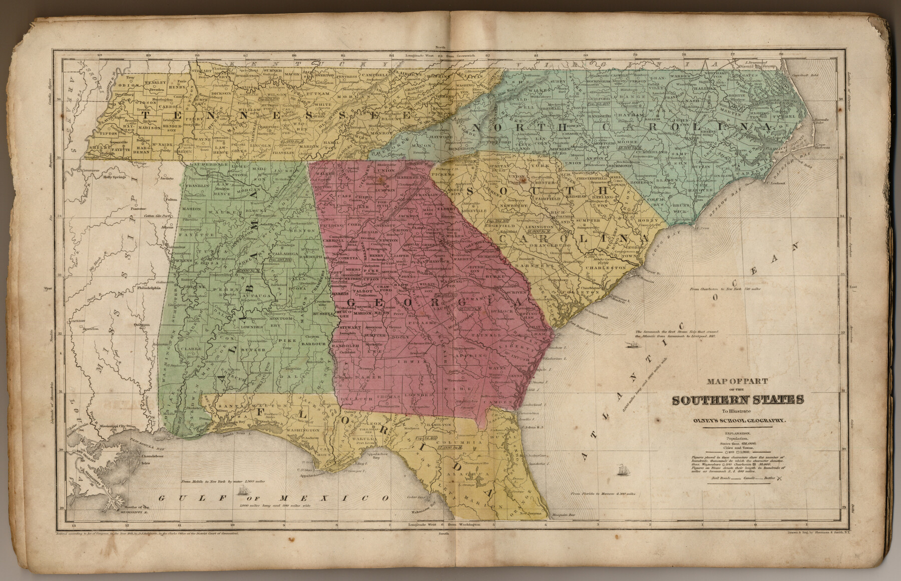
Map of part of the Southern States to illustrate Olney's school geography
-
Map/Doc
93540
-
Collection
General Map Collection
-
Object Dates
1844 (Creation Date)
2013/7/12 (File Date)
-
People and Organizations
Pratt, Woodford and Co. (Publisher)
Sherman and Smith (Printer)
Galen Greaser (Donor)
J. Olney (Author)
Sherman and Smith (Draftsman)
-
Subjects
Atlas
-
Height x Width
12.1 x 19.0 inches
30.7 x 48.3 cm
-
Comments
Donated by Galen Greaser in 2009. Map is part of volume: "Olney's School Atlas". See 93534 for a PDF of this complete atlas.
Related maps
Olney's School Atlas

Print $326.00
- Digital $50.00
Olney's School Atlas
1844
Size 12.3 x 10.0 inches
Map/Doc 93534
Part of: General Map Collection
Montgomery County Rolled Sketch 38

Print $40.00
- Digital $50.00
Montgomery County Rolled Sketch 38
1962
Size 56.0 x 30.8 inches
Map/Doc 9545
Orange County Sketch File 30

Print $20.00
- Digital $50.00
Orange County Sketch File 30
1926
Size 22.7 x 34.4 inches
Map/Doc 12124
San Saba County Working Sketch 3

Print $20.00
- Digital $50.00
San Saba County Working Sketch 3
1941
Size 27.3 x 20.7 inches
Map/Doc 63791
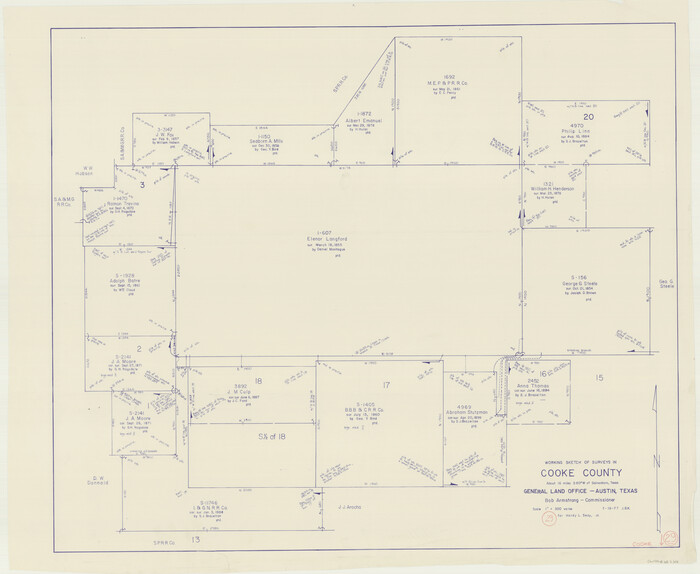
Cooke County Working Sketch 29
Print $20.00
- Digital $50.00
Cooke County Working Sketch 29
1977
Size 28.7 x 35.0 inches
Map/Doc 68266
Carte Geo-Hydrographique du Golfe du Mexique et de ses Isles construite d'après les mémoires les plus recens, et assujeties, pour l'emplacement de ces principales positions aux latitudes et longitudes

Print $20.00
- Digital $50.00
Carte Geo-Hydrographique du Golfe du Mexique et de ses Isles construite d'après les mémoires les plus recens, et assujeties, pour l'emplacement de ces principales positions aux latitudes et longitudes
1771
Size 15.0 x 20.5 inches
Map/Doc 94108
Current Miscellaneous File 110

Print $62.00
- Digital $50.00
Current Miscellaneous File 110
1972
Size 11.1 x 8.8 inches
Map/Doc 74713
Right of Way and Track Map of The Missouri, Kansas & Texas Railway of Texas

Print $40.00
- Digital $50.00
Right of Way and Track Map of The Missouri, Kansas & Texas Railway of Texas
1918
Size 24.8 x 53.4 inches
Map/Doc 64534
Flight Mission No. DCL-7C, Frame 58, Kenedy County

Print $20.00
- Digital $50.00
Flight Mission No. DCL-7C, Frame 58, Kenedy County
1943
Size 15.3 x 15.1 inches
Map/Doc 86046
Pecos County Rolled Sketch 72

Print $30.00
- Digital $50.00
Pecos County Rolled Sketch 72
1934
Size 35.8 x 45.1 inches
Map/Doc 9704
Pecos County Rolled Sketch JAS

Print $20.00
- Digital $50.00
Pecos County Rolled Sketch JAS
1937
Size 34.9 x 31.4 inches
Map/Doc 9744
The North Coast of the Gulf of Mexico from St. Marks to Galveston

Print $20.00
- Digital $50.00
The North Coast of the Gulf of Mexico from St. Marks to Galveston
1844
Size 27.5 x 41.1 inches
Map/Doc 97396
Flight Mission No. CRE-2R, Frame 162, Jackson County

Print $20.00
- Digital $50.00
Flight Mission No. CRE-2R, Frame 162, Jackson County
1956
Size 18.5 x 22.3 inches
Map/Doc 85373
You may also like
Jasper County Working Sketch 35

Print $20.00
- Digital $50.00
Jasper County Working Sketch 35
2008
Size 28.5 x 40.0 inches
Map/Doc 88733

Engineer map showing engineer information at 23 O'Clock 23 Oct. 1918 drawn under direction of Col. W.A. Mitchell - Verso

Print $20.00
Engineer map showing engineer information at 23 O'Clock 23 Oct. 1918 drawn under direction of Col. W.A. Mitchell - Verso
1918
Size 19.7 x 12.6 inches
Map/Doc 94128
Lamar County Sketch File 12

Print $20.00
- Digital $50.00
Lamar County Sketch File 12
Size 19.5 x 23.3 inches
Map/Doc 11967

San Augustine County Working Sketch 24

Print $20.00
- Digital $50.00
San Augustine County Working Sketch 24
1975
Size 27.8 x 39.1 inches
Map/Doc 63712
[Blocks M17, M18, M23, H, I, Z, and XO2]
![91245, [Blocks M17, M18, M23, H, I, Z, and XO2], Twichell Survey Records](https://historictexasmaps.com/wmedia_w700/maps/91245-1.tif.jpg)
Print $20.00
- Digital $50.00
[Blocks M17, M18, M23, H, I, Z, and XO2]
Size 34.5 x 27.2 inches
Map/Doc 91245
Flight Mission No. DQN-2K, Frame 44, Calhoun County

Print $20.00
- Digital $50.00
Flight Mission No. DQN-2K, Frame 44, Calhoun County
1953
Size 18.4 x 22.1 inches
Map/Doc 84249
Johnson County Sketch File 10a

Print $4.00
- Digital $50.00
Johnson County Sketch File 10a
1877
Size 6.7 x 10.6 inches
Map/Doc 28445
From Citizens Living Between the Brazos and Trinity Rivers and Below the Old San Antonio Road in Montgomery and Washington Counties for the Creation of a New County to be Called Travis, Undated

Print $20.00
From Citizens Living Between the Brazos and Trinity Rivers and Below the Old San Antonio Road in Montgomery and Washington Counties for the Creation of a New County to be Called Travis, Undated
2020
Size 21.2 x 21.7 inches
Map/Doc 96401
[Sketch for Mineral Application 33721 - 33725 Incl. - Padre and Mustang Island]
![2874, [Sketch for Mineral Application 33721 - 33725 Incl. - Padre and Mustang Island], General Map Collection](https://historictexasmaps.com/wmedia_w700/maps/2874.tif.jpg)
Print $20.00
- Digital $50.00
[Sketch for Mineral Application 33721 - 33725 Incl. - Padre and Mustang Island]
1941
Size 40.2 x 22.8 inches
Map/Doc 2874
Kerr County Working Sketch 3

Print $20.00
- Digital $50.00
Kerr County Working Sketch 3
1944
Size 15.7 x 21.0 inches
Map/Doc 70034