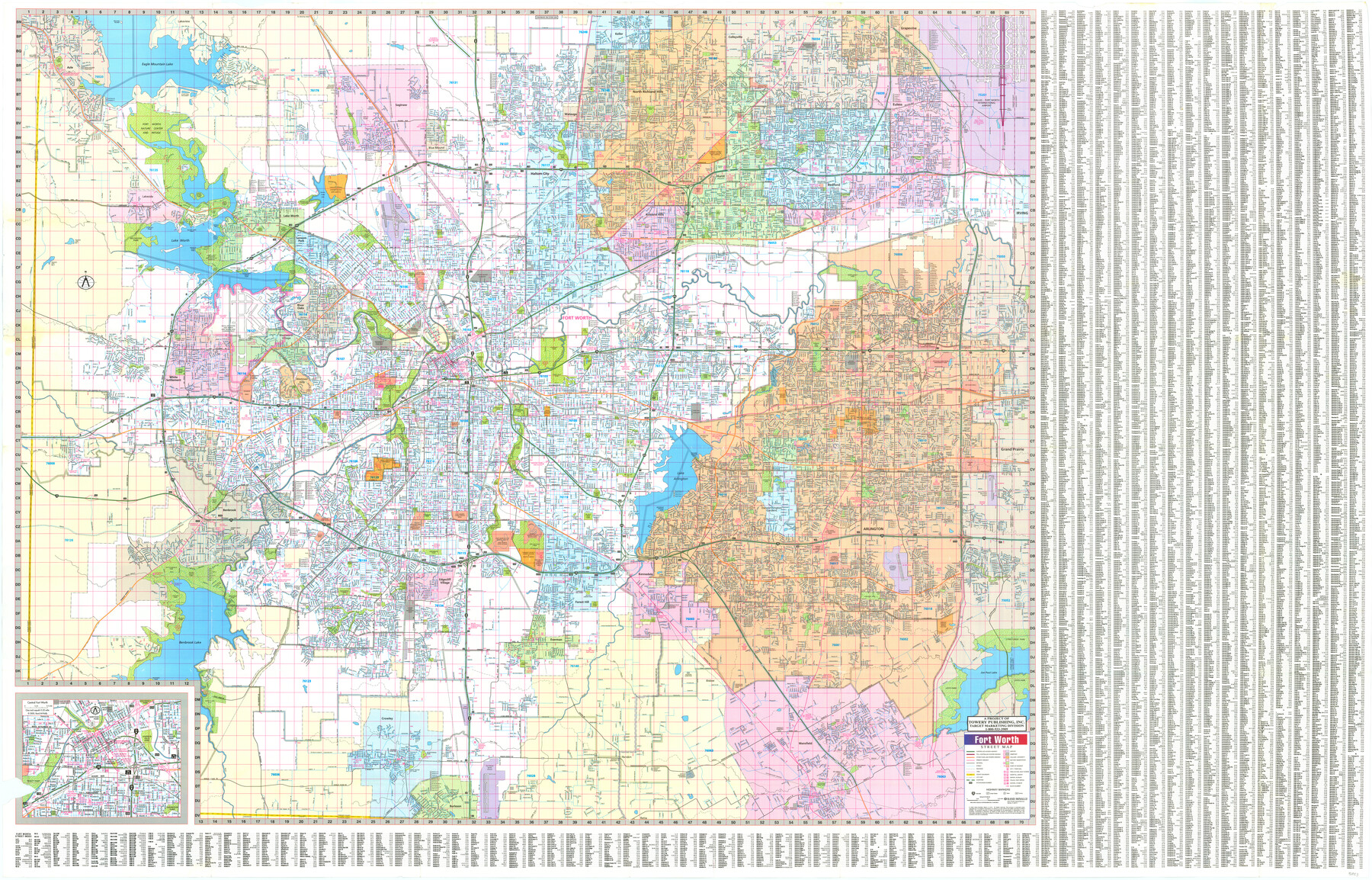
Fort Worth Street Guide
-
Map/Doc
96853
-
Collection
General Map Collection
-
Object Dates
2000 (Creation Date)
-
People and Organizations
Towery Publishing, Inc. (Publisher)
Mark Lambert (Donor)
-
Counties
Tarrant
-
Subjects
City
-
Height x Width
37.6 x 58.7 inches
95.5 x 149.1 cm
-
Medium
paper, print
-
Scale
1" = 0.66 mile
-
Comments
For research only. Donated by Mark Lambert in May, 2022. See 96854 for verso.
Related maps

Part of: General Map Collection
Pecos County Sketch File 28a

Print $14.00
- Digital $50.00
Pecos County Sketch File 28a
1911
Size 14.5 x 8.9 inches
Map/Doc 33683
Flight Mission No. CRC-3R, Frame 8, Chambers County

Print $20.00
- Digital $50.00
Flight Mission No. CRC-3R, Frame 8, Chambers County
1956
Size 18.6 x 22.2 inches
Map/Doc 84782
Dawson County Boundary File 1

Print $48.00
- Digital $50.00
Dawson County Boundary File 1
Size 8.8 x 4.0 inches
Map/Doc 52314
Map of Ellis County

Print $20.00
- Digital $50.00
Map of Ellis County
1871
Size 18.9 x 26.6 inches
Map/Doc 4493
Briscoe County Boundary File 4

Print $66.00
- Digital $50.00
Briscoe County Boundary File 4
Size 8.7 x 7.1 inches
Map/Doc 50780
Webb County Sketch File 11-1

Print $8.00
- Digital $50.00
Webb County Sketch File 11-1
1884
Size 11.3 x 8.5 inches
Map/Doc 39781

South Part Presidio County

Print $20.00
- Digital $50.00
South Part Presidio County
1975
Size 31.6 x 37.2 inches
Map/Doc 77400
Presidio County Sketch File 43

Print $10.00
- Digital $50.00
Presidio County Sketch File 43
1913
Size 11.2 x 8.7 inches
Map/Doc 34520
Denton County Rolled Sketch 3

Print $20.00
- Digital $50.00
Denton County Rolled Sketch 3
1959
Size 39.1 x 23.9 inches
Map/Doc 5700
No. 2 Chart of Corpus Christi Pass, Texas

Print $20.00
- Digital $50.00
No. 2 Chart of Corpus Christi Pass, Texas
1878
Size 18.2 x 27.2 inches
Map/Doc 73029
East Part of Liberty Co.

Print $20.00
- Digital $50.00
East Part of Liberty Co.
1977
Size 41.0 x 30.9 inches
Map/Doc 77352
You may also like
Map showing the location of the Pecos Valley Railway through H. &. G. N. R.R. Co. Land in Reeves Co., Texas

Print $20.00
- Digital $50.00
Map showing the location of the Pecos Valley Railway through H. &. G. N. R.R. Co. Land in Reeves Co., Texas
1891
Size 37.9 x 42.6 inches
Map/Doc 64708
A Pocket Guide to Austin, Texas - Area Map and Downtown Map

A Pocket Guide to Austin, Texas - Area Map and Downtown Map
Size 17.0 x 20.1 inches
Map/Doc 94385
Flight Mission No. CRC-6R, Frame 38, Chambers County

Print $20.00
- Digital $50.00
Flight Mission No. CRC-6R, Frame 38, Chambers County
1956
Size 18.7 x 22.4 inches
Map/Doc 84971
San Jacinto County Working Sketch 33

Print $20.00
- Digital $50.00
San Jacinto County Working Sketch 33
1955
Size 25.4 x 31.8 inches
Map/Doc 63746
Flight Mission No. CRC-3R, Frame 24, Chambers County

Print $20.00
- Digital $50.00
Flight Mission No. CRC-3R, Frame 24, Chambers County
1956
Size 18.6 x 22.2 inches
Map/Doc 84798
Trinity County Sketch File 30

Print $8.00
- Digital $50.00
Trinity County Sketch File 30
1891
Size 14.2 x 8.9 inches
Map/Doc 38566
Swisher County Sketch File 7

Print $32.00
- Digital $50.00
Swisher County Sketch File 7
1904
Size 9.0 x 8.4 inches
Map/Doc 37622
Flight Mission No. DQN-6K, Frame 16, Calhoun County

Print $20.00
- Digital $50.00
Flight Mission No. DQN-6K, Frame 16, Calhoun County
1953
Size 18.7 x 22.2 inches
Map/Doc 84438
Blanco County Working Sketch 30

Print $20.00
- Digital $50.00
Blanco County Working Sketch 30
1971
Size 22.9 x 34.6 inches
Map/Doc 67390
Terry County Sketch File 6

Print $8.00
- Digital $50.00
Terry County Sketch File 6
1924
Size 11.2 x 8.7 inches
Map/Doc 38026
Val Verde County Working Sketch 20

Print $20.00
- Digital $50.00
Val Verde County Working Sketch 20
1929
Size 30.5 x 20.2 inches
Map/Doc 72155
Houston Dis. Cochino Bayou

Print $2.00
- Digital $50.00
Houston Dis. Cochino Bayou
1847
Size 11.3 x 8.2 inches
Map/Doc 184