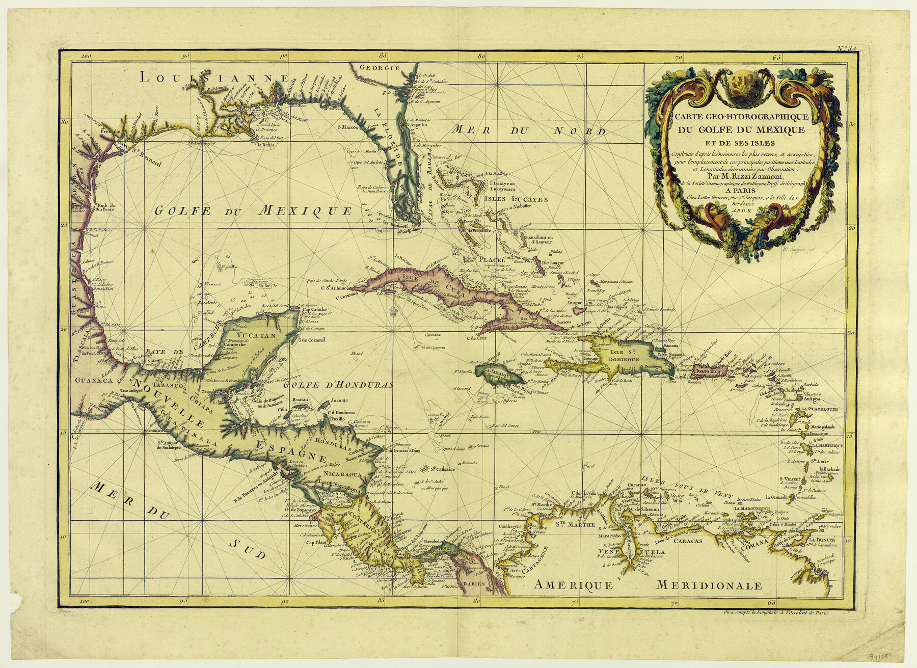
Carte Geo-Hydrographique du Golfe du Mexique et de ses Isles construite d'après les mémoires les plus recens, et assujeties, pour l'emplacement de ces principales positions aux latitudes et longitudes
-
Map/Doc
94108
-
Collection
General Map Collection
-
Object Dates
1771 (Creation Date)
-
People and Organizations
Chez Lattre (Printer)
[Giovanni Antonio] Rizzi Zannoni (Cartographer)
-
Subjects
Gulf of Mexico
-
Height x Width
15.0 x 20.5 inches
38.1 x 52.1 cm
-
Medium
paper, etching/engraving/lithograph
Part of: General Map Collection
Motley County Sketch File 6 (N)

Print $20.00
- Digital $50.00
Motley County Sketch File 6 (N)
1900
Size 14.0 x 8.6 inches
Map/Doc 32004
Starr County Rolled Sketch 21

Print $20.00
- Digital $50.00
Starr County Rolled Sketch 21
1921
Size 24.2 x 14.0 inches
Map/Doc 7805
Gillespie County Boundary File 7a

Print $40.00
- Digital $50.00
Gillespie County Boundary File 7a
Size 8.7 x 51.2 inches
Map/Doc 53780
Henderson County Working Sketch 38

Print $20.00
- Digital $50.00
Henderson County Working Sketch 38
1982
Size 19.3 x 17.0 inches
Map/Doc 66171
Map of north end of Brazos Island

Print $20.00
- Digital $50.00
Map of north end of Brazos Island
1845
Size 24.3 x 18.3 inches
Map/Doc 72919
Colorado County Boundary File 2

Print $8.00
- Digital $50.00
Colorado County Boundary File 2
Size 14.3 x 8.7 inches
Map/Doc 51772
Travis County Working Sketch 26

Print $20.00
- Digital $50.00
Travis County Working Sketch 26
1951
Size 34.8 x 25.1 inches
Map/Doc 69410
Presidio County Working Sketch 78

Print $20.00
- Digital $50.00
Presidio County Working Sketch 78
1965
Size 24.8 x 25.1 inches
Map/Doc 71755
Liberty County Sketch File 25

Print $8.00
- Digital $50.00
Liberty County Sketch File 25
1861
Size 8.0 x 10.0 inches
Map/Doc 29939
King County Working Sketch Graphic Index

Print $20.00
- Digital $50.00
King County Working Sketch Graphic Index
1947
Size 44.2 x 39.5 inches
Map/Doc 76608
Sterling County Rolled Sketch 11

Print $20.00
- Digital $50.00
Sterling County Rolled Sketch 11
1884
Size 22.5 x 46.6 inches
Map/Doc 9945
Henderson County Rolled Sketch 1

Print $20.00
- Digital $50.00
Henderson County Rolled Sketch 1
1942
Size 34.0 x 38.3 inches
Map/Doc 9159
You may also like
The Republic County of Harris. Proposed, Late Fall 1837-May 15, 1838

Print $20.00
The Republic County of Harris. Proposed, Late Fall 1837-May 15, 1838
2020
Size 17.7 x 21.7 inches
Map/Doc 96162
Marion County Sketch File 11

Print $4.00
- Digital $50.00
Marion County Sketch File 11
1902
Size 11.2 x 8.6 inches
Map/Doc 30581
Knox County Working Sketch 13

Print $3.00
- Digital $50.00
Knox County Working Sketch 13
1953
Size 9.6 x 11.0 inches
Map/Doc 70255

Nueces County Sketch File 30

Print $3.00
- Digital $50.00
Nueces County Sketch File 30
1907
Size 11.4 x 11.9 inches
Map/Doc 32600
![91783, [Block M-19], Twichell Survey Records](https://historictexasmaps.com/wmedia_w700/maps/91783-1.tif.jpg)
Hood County Working Sketch 6

Print $40.00
- Digital $50.00
Hood County Working Sketch 6
1969
Size 39.4 x 48.0 inches
Map/Doc 66200
Carson County Working Sketch Graphic Index

Print $20.00
- Digital $50.00
Carson County Working Sketch Graphic Index
1932
Size 41.3 x 37.9 inches
Map/Doc 76488
Clay County Sketch File 32

Print $22.00
- Digital $50.00
Clay County Sketch File 32
Size 8.6 x 7.8 inches
Map/Doc 18458
Val Verde County Sketch File B

Print $28.00
- Digital $50.00
Val Verde County Sketch File B
1897
Size 20.2 x 15.0 inches
Map/Doc 12542
Flight Mission No. CON-2R, Frame 94, Stonewall County

Print $20.00
- Digital $50.00
Flight Mission No. CON-2R, Frame 94, Stonewall County
1957
Size 18.5 x 22.2 inches
Map/Doc 86988
[Capitol Leagues 216-229]
![90705, [Capitol Leagues 216-229], Twichell Survey Records](https://historictexasmaps.com/wmedia_w700/maps/90705-1.tif.jpg)
Print $20.00
- Digital $50.00
[Capitol Leagues 216-229]
Size 25.2 x 26.7 inches
Map/Doc 90705