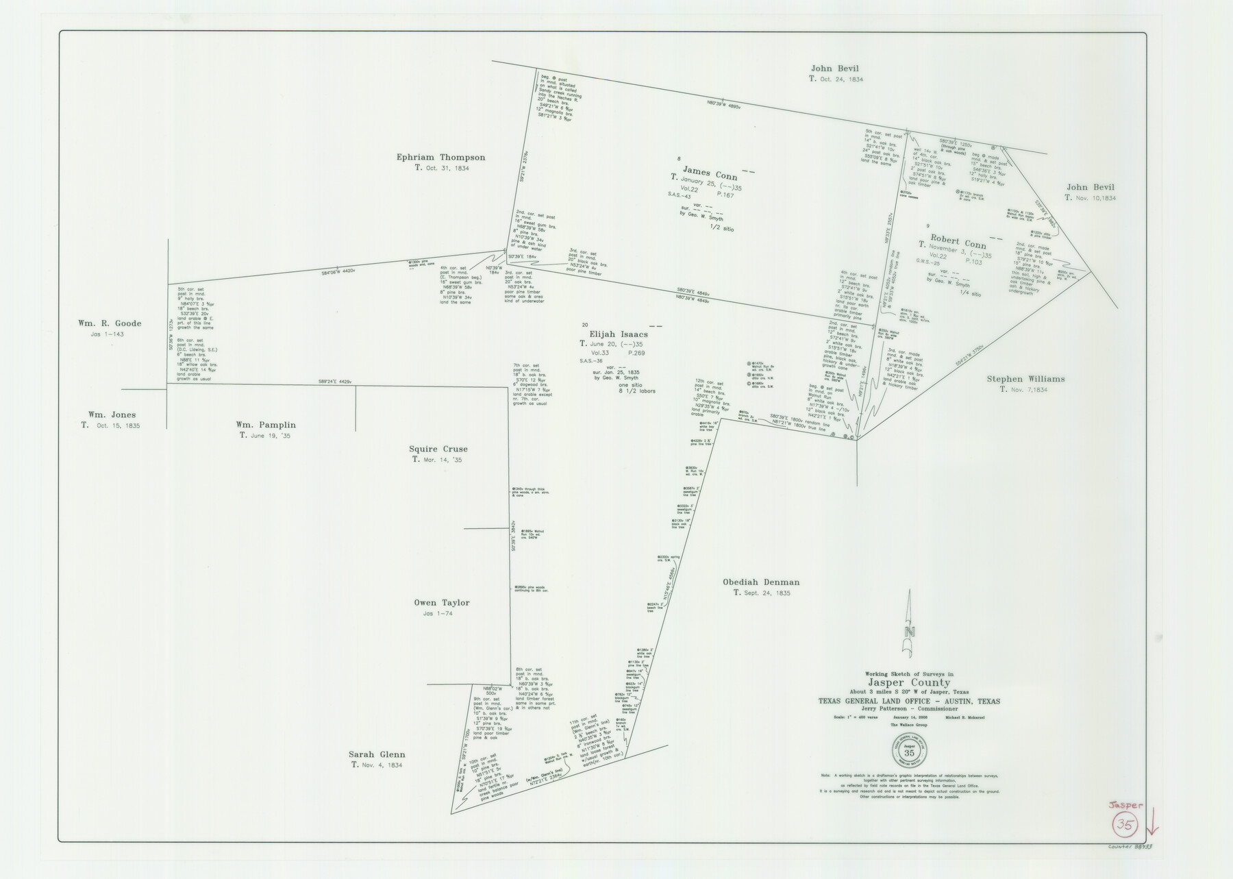
Jasper County Working Sketch 35
-
Map/Doc
88733
-
Collection
General Map Collection
-
Object Dates
1/14/2008 (Creation Date)
-
People and Organizations
Michael R. Mokarzel (Draftsman)
Jerry E. Patterson (GLO Commissioner)
-
Counties
Jasper
-
Subjects
Surveying Working Sketch
-
Height x Width
28.5 x 40.0 inches
72.4 x 101.6 cm
-
Scale
1" = 400 varas
-
Comments
Survey covers the following files: Elijah Isaacs, Title June 6, 1835, Robert Conn, Title November 3, 1835 and James Conn Title January 25, 1835.
Survey located about three miles South 20 degrees West of Jasper, Texas.
Part of: General Map Collection
Fayette County Rolled Sketch K

Print $20.00
- Digital $50.00
Fayette County Rolled Sketch K
1936
Size 41.2 x 40.0 inches
Map/Doc 8886
Upton County Sketch File 35

Print $14.00
- Digital $50.00
Upton County Sketch File 35
1942
Size 11.4 x 8.8 inches
Map/Doc 38886
Val Verde County Working Sketch 2

Print $20.00
- Digital $50.00
Val Verde County Working Sketch 2
Size 27.9 x 23.8 inches
Map/Doc 72137
Milam County Boundary File 6c

Print $2.00
- Digital $50.00
Milam County Boundary File 6c
Size 11.2 x 8.5 inches
Map/Doc 57250
San Patricio County Working Sketch 12

Print $40.00
- Digital $50.00
San Patricio County Working Sketch 12
Size 51.4 x 40.7 inches
Map/Doc 63774
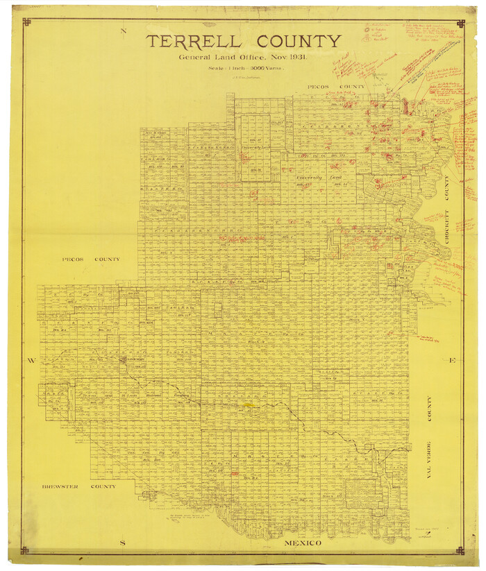
Terrell County Rolled Sketch 58
Print $40.00
- Digital $50.00
Terrell County Rolled Sketch 58
1931
Size 49.1 x 41.8 inches
Map/Doc 9993

Bexar County Sketch File 44

Print $5.00
- Digital $50.00
Bexar County Sketch File 44
1844
Size 15.7 x 9.3 inches
Map/Doc 14524
Right of Way Track Map, Wichita Falls & Southern Railroad Company

Print $40.00
- Digital $50.00
Right of Way Track Map, Wichita Falls & Southern Railroad Company
1942
Size 24.5 x 56.1 inches
Map/Doc 64514
Mason County Working Sketch 23

Print $20.00
- Digital $50.00
Mason County Working Sketch 23
2004
Size 17.4 x 36.9 inches
Map/Doc 83577
Lubbock County

Print $20.00
- Digital $50.00
Lubbock County
1879
Size 23.8 x 21.7 inches
Map/Doc 3829
Matagorda County NRC Article 33.136 Sketch 11

Print $42.00
- Digital $50.00
Matagorda County NRC Article 33.136 Sketch 11
Size 18.0 x 24.0 inches
Map/Doc 94465
You may also like
Trace of a copy of the map captured at the battle of Resaca de la Palma

Print $20.00
- Digital $50.00
Trace of a copy of the map captured at the battle of Resaca de la Palma
Size 18.4 x 27.4 inches
Map/Doc 73055
Flight Mission No. DAG-21K, Frame 106, Matagorda County

Print $20.00
- Digital $50.00
Flight Mission No. DAG-21K, Frame 106, Matagorda County
1952
Size 18.6 x 22.5 inches
Map/Doc 86434
Map of Swisher Addition

Print $20.00
- Digital $50.00
Map of Swisher Addition
1910
Size 18.0 x 13.3 inches
Map/Doc 646
Revised Map of Pendleton-Baxter-Addition to Shamrock Located on N.E. 1/4 Section 37, Block 17 H. & G.N.RR.Co., Wheeler County, Texas

Print $20.00
- Digital $50.00
Revised Map of Pendleton-Baxter-Addition to Shamrock Located on N.E. 1/4 Section 37, Block 17 H. & G.N.RR.Co., Wheeler County, Texas
Size 16.7 x 18.8 inches
Map/Doc 92123
Val Verde County Working Sketch 28

Print $20.00
- Digital $50.00
Val Verde County Working Sketch 28
1937
Size 45.9 x 38.6 inches
Map/Doc 72163
Tom Green County

Print $40.00
- Digital $50.00
Tom Green County
Size 43.6 x 111.2 inches
Map/Doc 82058
Anderson County

Print $40.00
- Digital $50.00
Anderson County
1942
Size 52.9 x 47.9 inches
Map/Doc 66702
Hudspeth County Sketch File 12

Print $10.00
- Digital $50.00
Hudspeth County Sketch File 12
1901
Size 14.2 x 8.7 inches
Map/Doc 26924

Copy of Surveyor's Field Book, Morris Browning - In Blocks 7, 5 & 4, I&GNRRCo., Hutchinson and Carson Counties, Texas

Print $2.00
- Digital $50.00
Copy of Surveyor's Field Book, Morris Browning - In Blocks 7, 5 & 4, I&GNRRCo., Hutchinson and Carson Counties, Texas
1888
Size 7.0 x 8.8 inches
Map/Doc 62259

[Map of a portion of Bexar and Travis Districts]
![16943, [Map of a portion of Bexar and Travis Districts], General Map Collection](https://historictexasmaps.com/wmedia_w700/maps/16943.tif.jpg)
Print $20.00
- Digital $50.00
[Map of a portion of Bexar and Travis Districts]
Size 47.5 x 47.2 inches
Map/Doc 16943