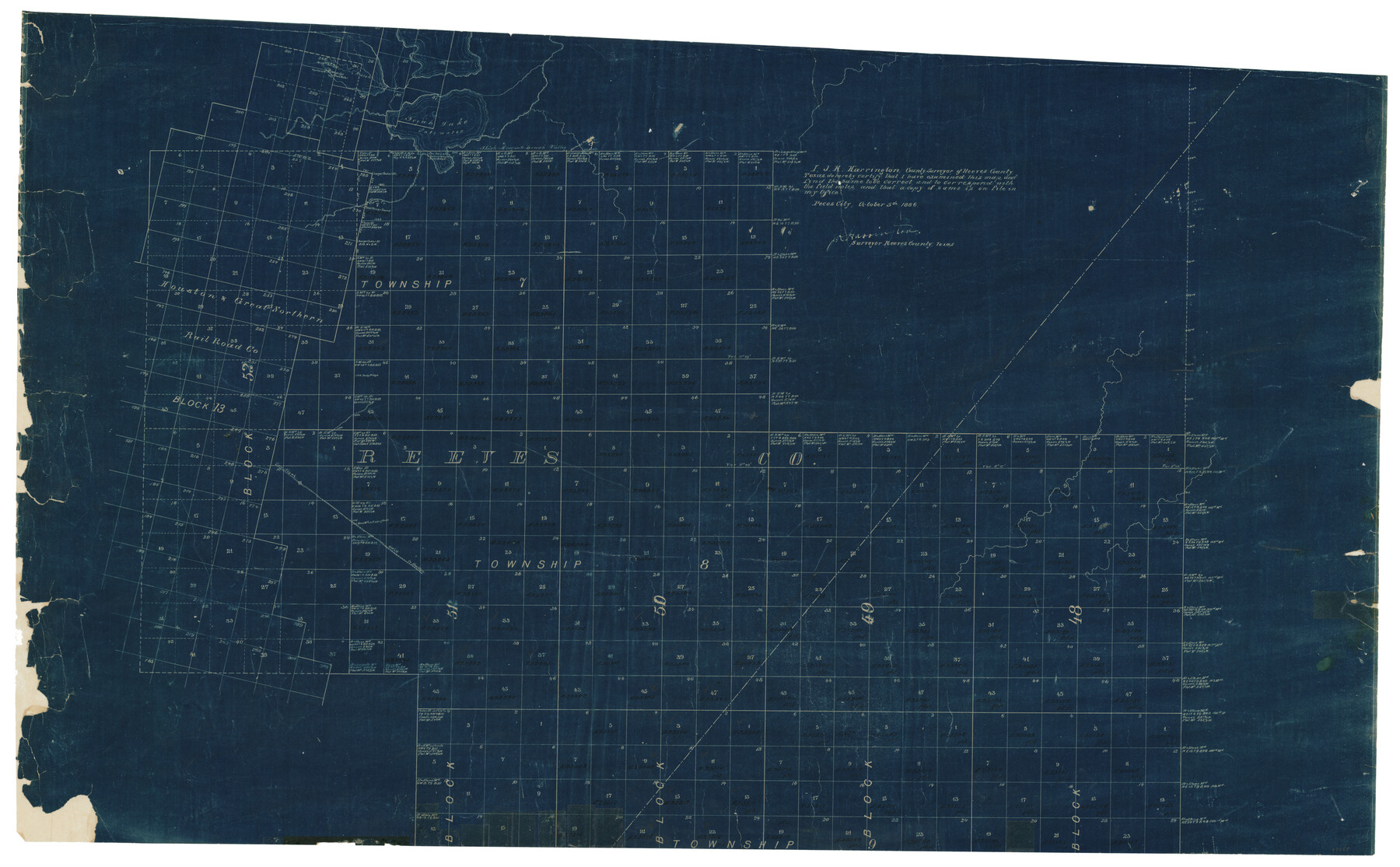
Pecos County Rolled Sketch 22
Map of surveys in Blocks 48, 49, 50, 51, and 52 of the Texas and Pacific Railway Co. in Reeves and Pecos Counties
-
Map/Doc
93455
-
Collection
General Map Collection
-
Object Dates
10/2/1886 (Creation Date)
11/22/1886 (File Date)
2/1886 (Survey Date)
-
People and Organizations
Murray Harris (Surveyor/Engineer)
-
Counties
Pecos Reeves
-
Subjects
Surveying Rolled Sketch
-
Height x Width
24.3 x 37.0 inches
61.7 x 94.0 cm
-
Medium
blueprint/diazo
-
Scale
1" = 2000 varas
-
Comments
Conserved in 3 pieces. See 9687 and 93454 for other pieces and see 93461 for digital composite of full map. Conservation funded in 2013 by Friends of the Texas General Land Office.
Related maps
Pecos County Rolled Sketch 22

Print $20.00
- Digital $50.00
Pecos County Rolled Sketch 22
1886
Size 22.4 x 36.8 inches
Map/Doc 93454
Pecos County Rolled Sketch 22

Print $40.00
- Digital $50.00
Pecos County Rolled Sketch 22
1886
Size 73.4 x 45.2 inches
Map/Doc 93461
Pecos County Rolled Sketch 22

Print $20.00
- Digital $50.00
Pecos County Rolled Sketch 22
1886
Size 22.5 x 39.5 inches
Map/Doc 9687
Part of: General Map Collection

Webb County Rolled Sketch 40

Print $20.00
- Digital $50.00
Webb County Rolled Sketch 40
1941
Size 20.6 x 18.4 inches
Map/Doc 8195
Lampasas County Sketch File 8

Print $4.00
- Digital $50.00
Lampasas County Sketch File 8
1872
Size 8.8 x 7.7 inches
Map/Doc 29406
East Part of Brewster Co.

Print $40.00
- Digital $50.00
East Part of Brewster Co.
1952
Size 48.7 x 29.6 inches
Map/Doc 66734
Reeves County Sketch File 7

Print $20.00
- Digital $50.00
Reeves County Sketch File 7
Size 18.3 x 19.9 inches
Map/Doc 12243
Real County Working Sketch 50

Print $20.00
- Digital $50.00
Real County Working Sketch 50
1957
Size 19.8 x 26.1 inches
Map/Doc 71942
Flight Mission No. CGI-2N, Frame 180, Cameron County

Print $20.00
- Digital $50.00
Flight Mission No. CGI-2N, Frame 180, Cameron County
1954
Size 18.5 x 22.1 inches
Map/Doc 84540
Plan B, Part 3rd Shewing that portion of the boundary between Texas and the United States, included between Logan's Ferry on the River Sabine and the intersection of the 32nd degree of N. Latitude with the western bank of the said river

Print $20.00
- Digital $50.00
Plan B, Part 3rd Shewing that portion of the boundary between Texas and the United States, included between Logan's Ferry on the River Sabine and the intersection of the 32nd degree of N. Latitude with the western bank of the said river
1842
Size 19.4 x 27.2 inches
Map/Doc 65411
Morris County Rolled Sketch 2A

Print $20.00
- Digital $50.00
Morris County Rolled Sketch 2A
Size 24.0 x 18.6 inches
Map/Doc 10235
Crosby County Sketch File 3

Print $36.00
- Digital $50.00
Crosby County Sketch File 3
1885
Size 12.8 x 8.7 inches
Map/Doc 19992
Flight Mission No. DQN-5K, Frame 24, Calhoun County

Print $20.00
- Digital $50.00
Flight Mission No. DQN-5K, Frame 24, Calhoun County
1953
Size 18.5 x 22.1 inches
Map/Doc 84375
Current Miscellaneous File 63

Print $6.00
- Digital $50.00
Current Miscellaneous File 63
1957
Size 14.1 x 8.8 inches
Map/Doc 74100
You may also like
Live Oak County Working Sketch 24

Print $20.00
- Digital $50.00
Live Oak County Working Sketch 24
1978
Size 31.9 x 38.2 inches
Map/Doc 70609
Williamson County Rolled Sketch 3

Print $20.00
- Digital $50.00
Williamson County Rolled Sketch 3
1915
Size 40.1 x 30.9 inches
Map/Doc 8261
Sutton County Sketch File 3

Print $8.00
- Digital $50.00
Sutton County Sketch File 3
Size 12.9 x 8.5 inches
Map/Doc 37353
[Blocks JK, JK4, JD, A1, and A2]
![90748, [Blocks JK, JK4, JD, A1, and A2], Twichell Survey Records](https://historictexasmaps.com/wmedia_w700/maps/90748-1.tif.jpg)
Print $20.00
- Digital $50.00
[Blocks JK, JK4, JD, A1, and A2]
Size 12.5 x 28.8 inches
Map/Doc 90748
Bell County Sketch File 31

Print $4.00
- Digital $50.00
Bell County Sketch File 31
1882
Size 8.0 x 8.9 inches
Map/Doc 14445
Zavala County Sketch File 11

Print $4.00
- Digital $50.00
Zavala County Sketch File 11
1885
Size 14.4 x 8.8 inches
Map/Doc 41270
Brazoria County Rolled Sketch 25

Print $40.00
- Digital $50.00
Brazoria County Rolled Sketch 25
1935
Size 50.8 x 33.5 inches
Map/Doc 8928
Flight Mission No. DCL-6C, Frame 158, Kenedy County

Print $20.00
- Digital $50.00
Flight Mission No. DCL-6C, Frame 158, Kenedy County
1943
Size 15.3 x 15.2 inches
Map/Doc 85984
Reeves County Rolled Sketch 2

Print $20.00
- Digital $50.00
Reeves County Rolled Sketch 2
1890
Size 34.0 x 39.5 inches
Map/Doc 9845
Amistad International Reservoir on Rio Grande 62

Print $20.00
- Digital $50.00
Amistad International Reservoir on Rio Grande 62
1949
Size 28.2 x 39.6 inches
Map/Doc 73347
Flight Mission No. BRA-8M, Frame 125, Jefferson County

Print $20.00
- Digital $50.00
Flight Mission No. BRA-8M, Frame 125, Jefferson County
1953
Size 15.9 x 15.7 inches
Map/Doc 85621
Newton County Rolled Sketch 5

Print $20.00
- Digital $50.00
Newton County Rolled Sketch 5
Size 20.5 x 42.5 inches
Map/Doc 6841