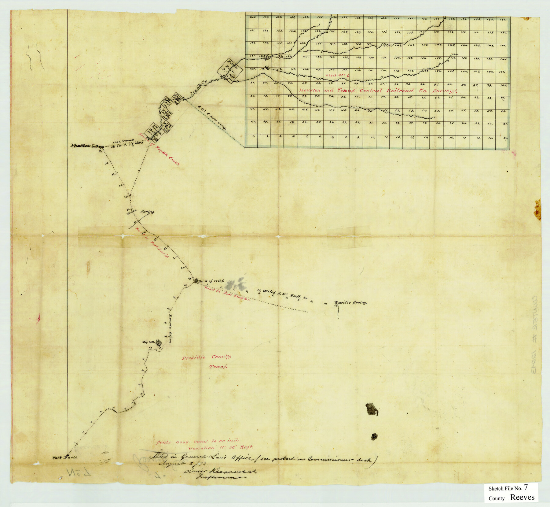
Reeves County Sketch File 7
[H&TCRRCo. Block 1, Reeves County, Texas]
-
Map/Doc
12243
-
Collection
General Map Collection
-
Object Dates
1873/8/8 (File Date)
-
People and Organizations
Louis Kearnmant (Draftsman)
-
Counties
Reeves Presidio
-
Subjects
Surveying Sketch File
-
Height x Width
18.3 x 19.9 inches
46.5 x 50.5 cm
-
Medium
paper, manuscript
-
Scale
1:4000
-
Features
Toyah Creek
Phantom Lake
Road to Fort Davis
Road to Fort Stockton
Barillo Spring
Lympia Canon
Fort Davis
Part of: General Map Collection
Sutton County Boundary File 3

Print $22.00
- Digital $50.00
Sutton County Boundary File 3
Size 14.2 x 8.7 inches
Map/Doc 59024
Current Miscellaneous File 26

Print $4.00
- Digital $50.00
Current Miscellaneous File 26
1952
Size 10.7 x 8.3 inches
Map/Doc 73907
Foard County Sketch File 7

Print $3.00
- Digital $50.00
Foard County Sketch File 7
1872
Size 10.0 x 17.2 inches
Map/Doc 11491
Hartley County Sketch File 18

Print $4.00
- Digital $50.00
Hartley County Sketch File 18
2001
Size 11.1 x 8.7 inches
Map/Doc 76330
Webb County Boundary File 3a

Print $10.00
- Digital $50.00
Webb County Boundary File 3a
Size 14.2 x 8.7 inches
Map/Doc 59753
Supreme Court of the United States, October Term, 1923, No. 15, Original - The State of Oklahoma, Complainant vs. The State of Texas, Defendant, The United States, Intervener; Report of the Boundary Commissioners

Print $20.00
- Digital $50.00
Supreme Court of the United States, October Term, 1923, No. 15, Original - The State of Oklahoma, Complainant vs. The State of Texas, Defendant, The United States, Intervener; Report of the Boundary Commissioners
1923
Size 39.4 x 39.6 inches
Map/Doc 75116

Colorado County Sketch File 10

Print $48.00
- Digital $50.00
Colorado County Sketch File 10
1872
Size 9.2 x 7.9 inches
Map/Doc 18929
Comal County Sketch File 12

Print $4.00
- Digital $50.00
Comal County Sketch File 12
Size 8.4 x 11.3 inches
Map/Doc 19024
Schleicher County Rolled Sketch 3

Print $20.00
- Digital $50.00
Schleicher County Rolled Sketch 3
1890
Size 41.5 x 31.2 inches
Map/Doc 8362
Nueces County Sketch File 30

Print $3.00
- Digital $50.00
Nueces County Sketch File 30
1907
Size 11.4 x 11.9 inches
Map/Doc 32600
Val Verde County Rolled Sketch 10

Print $20.00
- Digital $50.00
Val Verde County Rolled Sketch 10
Size 22.9 x 27.8 inches
Map/Doc 8108
You may also like
Trace of a copy of the map captured at the battle of Resaca de la Palma

Print $20.00
- Digital $50.00
Trace of a copy of the map captured at the battle of Resaca de la Palma
Size 18.3 x 27.6 inches
Map/Doc 73053
Matagorda County Rolled Sketch 38

Print $295.00
- Digital $50.00
Matagorda County Rolled Sketch 38
1984
Size 23.2 x 23.2 inches
Map/Doc 6697
Crane County Working Sketch 12

Print $20.00
- Digital $50.00
Crane County Working Sketch 12
1941
Size 18.6 x 18.1 inches
Map/Doc 68289
Eastland County Working Sketch 58

Print $20.00
- Digital $50.00
Eastland County Working Sketch 58
1985
Size 25.5 x 39.6 inches
Map/Doc 68839
Val Verde Co.

Print $20.00
- Digital $50.00
Val Verde Co.
1908
Size 41.2 x 37.3 inches
Map/Doc 78447
Plat of a survey on Padre Island in Cameron County surveyed for South Padre Development Corporation by Claunch and Associates

Print $40.00
- Digital $50.00
Plat of a survey on Padre Island in Cameron County surveyed for South Padre Development Corporation by Claunch and Associates
1970
Size 61.8 x 40.0 inches
Map/Doc 61429


Red River County Working Sketch 74

Print $20.00
- Digital $50.00
Red River County Working Sketch 74
1980
Size 24.2 x 22.8 inches
Map/Doc 72057
Duval County Rolled Sketch 17

Print $20.00
- Digital $50.00
Duval County Rolled Sketch 17
1940
Size 18.9 x 17.9 inches
Map/Doc 5738
Map of the State of Texas

Print $40.00
- Digital $50.00
Map of the State of Texas
1879
Size 102.7 x 106.6 inches
Map/Doc 16973
Bowie County Working Sketch 27

Print $20.00
- Digital $50.00
Bowie County Working Sketch 27
1987
Size 39.1 x 33.8 inches
Map/Doc 67431