Current Miscellaneous File 63
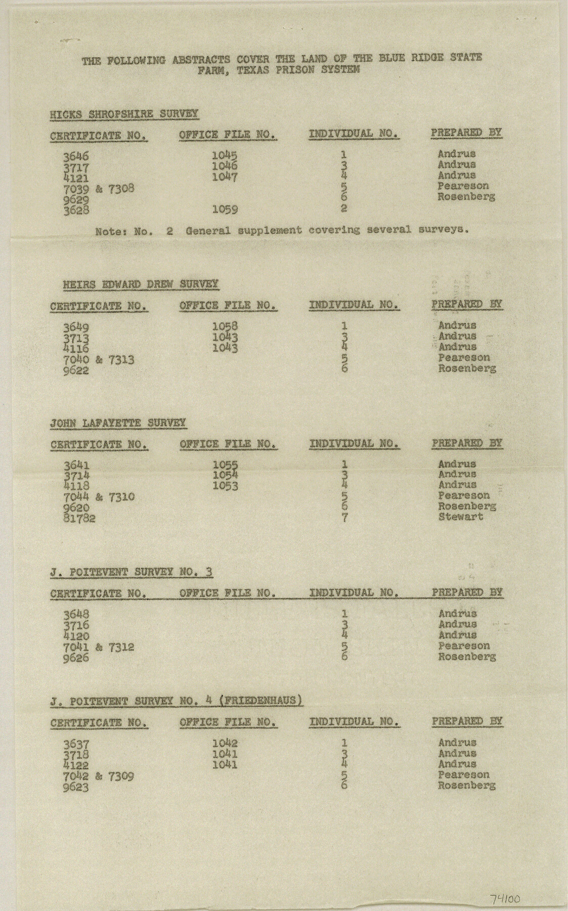
Abstracts covering the land of the Blue Ridge State Farm, Texas Prison System, Fort Bend County
-
Map/Doc
74100
-
Collection
General Map Collection
-
Object Dates
1957/1/16 (Creation Date)
1957/1/16 (File Date)
-
Subjects
Prison Farms
-
Height x Width
14.1 x 8.8 inches
35.8 x 22.4 cm
Part of: General Map Collection
Hardeman County Boundary File 2

Print $20.00
- Digital $50.00
Hardeman County Boundary File 2
Size 42.0 x 13.5 inches
Map/Doc 54374
Pecos County Rolled Sketch 124

Print $20.00
- Digital $50.00
Pecos County Rolled Sketch 124
Size 22.8 x 18.8 inches
Map/Doc 7265
Val Verde County Sketch File 2

Print $8.00
- Digital $50.00
Val Verde County Sketch File 2
1885
Size 12.8 x 8.0 inches
Map/Doc 39169
Nueces County Working Sketch 4

Print $20.00
- Digital $50.00
Nueces County Working Sketch 4
1951
Size 46.8 x 36.2 inches
Map/Doc 71306
Wharton County Sketch File 21

Print $40.00
- Digital $50.00
Wharton County Sketch File 21
1911
Size 14.8 x 13.0 inches
Map/Doc 39986
Jefferson County Working Sketch 31

Print $20.00
- Digital $50.00
Jefferson County Working Sketch 31
1982
Size 21.3 x 27.6 inches
Map/Doc 66575
Pecos County Rolled Sketch 101

Print $20.00
- Digital $50.00
Pecos County Rolled Sketch 101
1938
Size 22.5 x 39.0 inches
Map/Doc 7249
Rio Grande - North Extension Raymondville Sheet

Print $40.00
- Digital $50.00
Rio Grande - North Extension Raymondville Sheet
1937
Size 16.4 x 56.9 inches
Map/Doc 65104
Clay County Rolled Sketch 5

Print $20.00
- Digital $50.00
Clay County Rolled Sketch 5
Size 21.0 x 23.6 inches
Map/Doc 5499
Nueces County Working Sketch 6

Print $20.00
- Digital $50.00
Nueces County Working Sketch 6
1987
Size 33.7 x 42.9 inches
Map/Doc 71308
Presidio County Sketch File 106

Print $60.00
- Digital $50.00
Presidio County Sketch File 106
1983
Size 25.3 x 38.3 inches
Map/Doc 10580
Flight Mission No. BQR-5K, Frame 65, Brazoria County

Print $20.00
- Digital $50.00
Flight Mission No. BQR-5K, Frame 65, Brazoria County
1952
Size 18.8 x 22.5 inches
Map/Doc 84010
You may also like
General Highway Map, Howard County, Texas

Print $20.00
General Highway Map, Howard County, Texas
1961
Size 18.1 x 24.6 inches
Map/Doc 79526
Guadalupe County Sketch File 17

Print $4.00
- Digital $50.00
Guadalupe County Sketch File 17
1877
Size 10.2 x 8.5 inches
Map/Doc 24695

[Reconnaissance report of Lieut. Scariott around Laguna del Madre and up to Fort San Saba]
![73006, [Reconnaissance report of Lieut. Scariott around Laguna del Madre and up to Fort San Saba], General Map Collection](https://historictexasmaps.com/wmedia_w700/maps/73006.tif.jpg)
Print $20.00
- Digital $50.00
[Reconnaissance report of Lieut. Scariott around Laguna del Madre and up to Fort San Saba]
Size 25.2 x 18.2 inches
Map/Doc 73006
Haskell County Sketch File 4

Print $20.00
- Digital $50.00
Haskell County Sketch File 4
Size 17.7 x 18.6 inches
Map/Doc 11739
Ector County Working Sketch 17

Print $40.00
- Digital $50.00
Ector County Working Sketch 17
1956
Size 59.9 x 24.2 inches
Map/Doc 68860
Flight Mission No. DCL-6C, Frame 78, Kenedy County

Print $20.00
- Digital $50.00
Flight Mission No. DCL-6C, Frame 78, Kenedy County
1943
Size 17.5 x 20.7 inches
Map/Doc 85920
Cecil Stein Drilling Block

Print $3.00
- Digital $50.00
Cecil Stein Drilling Block
1933
Size 11.2 x 16.2 inches
Map/Doc 92281
Webb County Sketch File 3

Print $8.00
- Digital $50.00
Webb County Sketch File 3
Size 9.8 x 9.3 inches
Map/Doc 39713

Shelby County

Print $20.00
- Digital $50.00
Shelby County
1945
Size 39.1 x 44.2 inches
Map/Doc 77421
