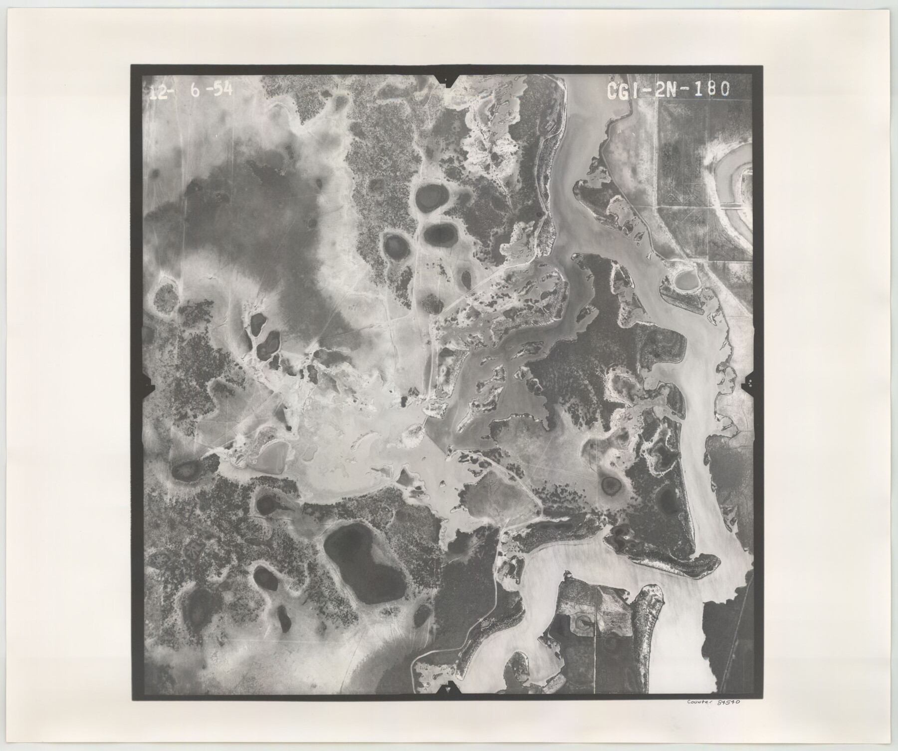
Flight Mission No. CGI-2N, Frame 180, Cameron County
CGI-2N-180
-
Map/Doc
84540
-
Collection
General Map Collection
-
Object Dates
1954/12/6 (Creation Date)
-
People and Organizations
U. S. Department of Agriculture (Publisher)
-
Counties
Cameron
-
Subjects
Aerial Photograph
-
Height x Width
18.5 x 22.1 inches
47.0 x 56.1 cm
-
Comments
Flown by Puckett Aerial Surveys, Inc. of Jackson, Mississippi.
Part of: General Map Collection
Pecos County Working Sketch 142

Print $40.00
- Digital $50.00
Pecos County Working Sketch 142
2007
Size 38.0 x 63.4 inches
Map/Doc 88610
King County Working Sketch 13

Print $20.00
- Digital $50.00
King County Working Sketch 13
1975
Size 33.0 x 47.8 inches
Map/Doc 70177
Flight Mission No. CRC-1R, Frame 154, Chambers County

Print $20.00
- Digital $50.00
Flight Mission No. CRC-1R, Frame 154, Chambers County
1956
Size 18.9 x 22.5 inches
Map/Doc 84716

[Sketch for Mineral Application 24072, San Jacinto River]
![65587, [Sketch for Mineral Application 24072, San Jacinto River], General Map Collection](https://historictexasmaps.com/wmedia_w700/maps/65587.tif.jpg)
Print $20.00
- Digital $50.00
[Sketch for Mineral Application 24072, San Jacinto River]
1929
Size 19.3 x 16.4 inches
Map/Doc 65587


Gregg County Rolled Sketch JB1

Print $20.00
- Digital $50.00
Gregg County Rolled Sketch JB1
1933
Size 43.3 x 33.4 inches
Map/Doc 9024
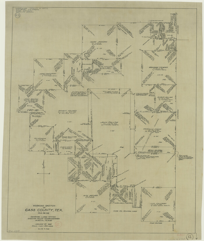
Cass County Working Sketch 12
Print $20.00
- Digital $50.00
Cass County Working Sketch 12
1942
Size 27.0 x 22.9 inches
Map/Doc 67915
Galveston County NRC Article 33.136 Sketch 9

Print $22.00
- Digital $50.00
Galveston County NRC Article 33.136 Sketch 9
1999
Size 18.8 x 25.1 inches
Map/Doc 61591
Orange County Working Sketch 48

Print $20.00
- Digital $50.00
Orange County Working Sketch 48
1991
Size 13.3 x 19.9 inches
Map/Doc 71380
Palo Pinto County Working Sketch 2

Print $20.00
- Digital $50.00
Palo Pinto County Working Sketch 2
1906
Size 15.2 x 46.2 inches
Map/Doc 71385
You may also like
Mexico und Texas

Print $20.00
- Digital $50.00
Mexico und Texas
1851
Size 15.8 x 19.1 inches
Map/Doc 93714
Kerr County Rolled Sketch 22

Print $20.00
- Digital $50.00
Kerr County Rolled Sketch 22
1959
Size 35.7 x 30.2 inches
Map/Doc 9349
Flight Mission No. CRC-3R, Frame 45, Chambers County

Print $20.00
- Digital $50.00
Flight Mission No. CRC-3R, Frame 45, Chambers County
1956
Size 18.6 x 22.5 inches
Map/Doc 84818
San Augustine County School Land for sale by Lubbock Irrigation Company

Print $20.00
- Digital $50.00
San Augustine County School Land for sale by Lubbock Irrigation Company
Size 24.0 x 25.2 inches
Map/Doc 92874
Brazoria County Rolled Sketch 18

Print $20.00
- Digital $50.00
Brazoria County Rolled Sketch 18
Size 28.0 x 22.5 inches
Map/Doc 5163
Flight Mission No. BRA-16M, Frame 145, Jefferson County

Print $20.00
- Digital $50.00
Flight Mission No. BRA-16M, Frame 145, Jefferson County
1953
Size 18.7 x 22.3 inches
Map/Doc 85751
Irion County Rolled Sketch 25

Print $20.00
- Digital $50.00
Irion County Rolled Sketch 25
2008
Size 35.7 x 24.4 inches
Map/Doc 89227
Midland County Sketch File 8

Print $20.00
- Digital $50.00
Midland County Sketch File 8
1933
Size 17.5 x 21.6 inches
Map/Doc 12084
General Highway Map, Colorado County, Texas

Print $20.00
General Highway Map, Colorado County, Texas
1961
Size 25.1 x 18.3 inches
Map/Doc 79416
The Republic County of Lamar. Created, December 17, 1840

Print $20.00
The Republic County of Lamar. Created, December 17, 1840
2020
Size 16.4 x 21.7 inches
Map/Doc 96202
Navigation Maps of Gulf Intracoastal Waterway, Port Arthur to Brownsville, Texas

Print $4.00
- Digital $50.00
Navigation Maps of Gulf Intracoastal Waterway, Port Arthur to Brownsville, Texas
1951
Size 16.7 x 21.5 inches
Map/Doc 65428
Clay County Sketch File 44

Print $20.00
- Digital $50.00
Clay County Sketch File 44
Size 24.7 x 36.0 inches
Map/Doc 11096