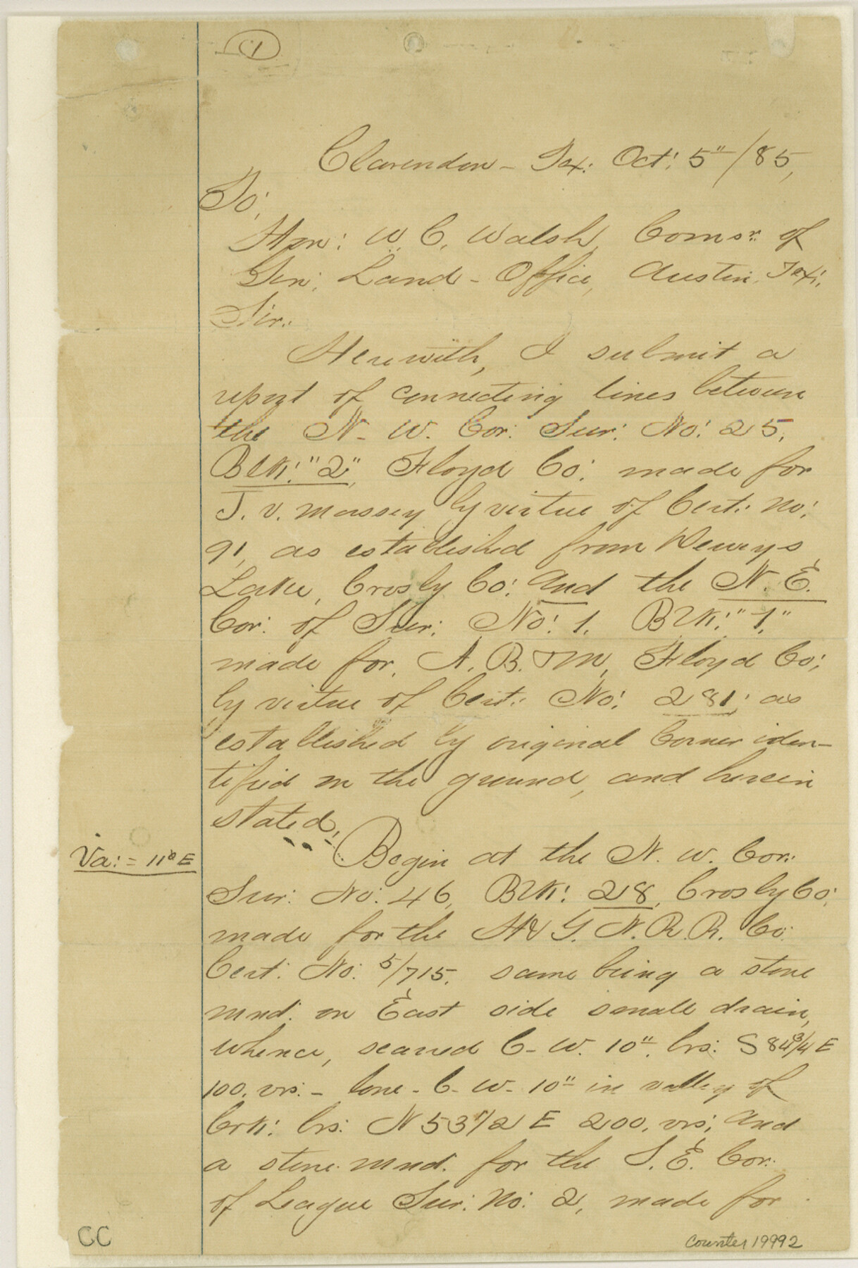
Crosby County Sketch File 3
[Report of connecting lines between the northwest corner of survey 25, Block 2 and the northeast corner of survey 1, Block 1]
-
Map/Doc
19992
-
Collection
General Map Collection
-
Object Dates
1885/10/3 (Creation Date)
1885/10/14 (File Date)
-
People and Organizations
T.S. McClelland (Surveyor/Engineer)
Nat Stewart (Chainman)
Tim Tuliny (Chainman)
A.K. Latham (Chainman)
Wm. J. Sweet (Chainman)
-
Counties
Crosby Floyd
-
Subjects
Surveying Sketch File
-
Height x Width
12.8 x 8.7 inches
32.5 x 22.1 cm
-
Medium
paper, manuscript
-
Features
Dewey's Lake
White River
Pease River
Spindle Mountain
Part of: General Map Collection
[St. Louis & Southwestern]
![64276, [St. Louis & Southwestern], General Map Collection](https://historictexasmaps.com/wmedia_w700/maps/64276.tif.jpg)
Print $20.00
- Digital $50.00
[St. Louis & Southwestern]
Size 20.9 x 28.7 inches
Map/Doc 64276
Flight Mission No. BRA-8M, Frame 135, Jefferson County

Print $20.00
- Digital $50.00
Flight Mission No. BRA-8M, Frame 135, Jefferson County
1953
Size 18.7 x 22.3 inches
Map/Doc 85631
Stonewall County Sketch File 18

Print $16.00
- Digital $50.00
Stonewall County Sketch File 18
1902
Size 13.7 x 8.4 inches
Map/Doc 37276
Armstrong County, State of Texas

Print $20.00
- Digital $50.00
Armstrong County, State of Texas
1888
Size 22.6 x 18.2 inches
Map/Doc 3245
Flight Mission No. DAG-17K, Frame 136, Matagorda County

Print $20.00
- Digital $50.00
Flight Mission No. DAG-17K, Frame 136, Matagorda County
1952
Size 18.5 x 22.3 inches
Map/Doc 86353
Bosque County Working Sketch 3

Print $20.00
- Digital $50.00
Bosque County Working Sketch 3
1901
Size 16.5 x 20.4 inches
Map/Doc 78192
Flight Mission No. CUG-3P, Frame 136, Kleberg County

Print $20.00
- Digital $50.00
Flight Mission No. CUG-3P, Frame 136, Kleberg County
1956
Size 18.5 x 22.3 inches
Map/Doc 86271
Crockett County Sketch File 82

Print $8.00
- Digital $50.00
Crockett County Sketch File 82
1940
Size 11.3 x 8.7 inches
Map/Doc 19895
Angelina County Sketch File 18c

Print $4.00
- Digital $50.00
Angelina County Sketch File 18c
Size 12.8 x 8.3 inches
Map/Doc 13034
Brown County Rolled Sketch 2

Print $20.00
- Digital $50.00
Brown County Rolled Sketch 2
1984
Size 42.4 x 25.2 inches
Map/Doc 5349
Pecos County Rolled Sketch 152

Print $20.00
- Digital $50.00
Pecos County Rolled Sketch 152
1960
Size 38.8 x 43.7 inches
Map/Doc 9736
El Paso County Sketch File 32

Print $8.00
- Digital $50.00
El Paso County Sketch File 32
1983
Size 14.3 x 8.9 inches
Map/Doc 22124
You may also like
Cass County Sketch File 18

Print $4.00
- Digital $50.00
Cass County Sketch File 18
Size 7.4 x 10.3 inches
Map/Doc 17420
Crockett County Working Sketch 97

Print $20.00
- Digital $50.00
Crockett County Working Sketch 97
1979
Size 39.4 x 37.4 inches
Map/Doc 68430
Dimmit County Sketch File 56

Print $20.00
- Digital $50.00
Dimmit County Sketch File 56
1939
Size 15.8 x 27.4 inches
Map/Doc 11360
Flight Mission No. BRA-7M, Frame 201, Jefferson County

Print $20.00
- Digital $50.00
Flight Mission No. BRA-7M, Frame 201, Jefferson County
1953
Size 18.6 x 22.4 inches
Map/Doc 85569
Mason County Rolled Sketch 6

Print $20.00
- Digital $50.00
Mason County Rolled Sketch 6
Size 19.5 x 22.2 inches
Map/Doc 6678
Garza County Sketch File F

Print $20.00
- Digital $50.00
Garza County Sketch File F
Size 9.8 x 18.9 inches
Map/Doc 11553
Map of The Surveyed Part of Peters Colony Texas

Print $40.00
- Digital $50.00
Map of The Surveyed Part of Peters Colony Texas
1858
Size 45.6 x 58.5 inches
Map/Doc 1982
Gillespie County Sketch File 9

Print $4.00
- Digital $50.00
Gillespie County Sketch File 9
1873
Size 8.2 x 10.5 inches
Map/Doc 24145
Working Sketch in Cottle, Foard & Hardeman Counties

Print $20.00
- Digital $50.00
Working Sketch in Cottle, Foard & Hardeman Counties
1917
Size 26.9 x 28.0 inches
Map/Doc 4485
Sketch showing progress of topographical work Laguna Madre and vicinity from Rainey Is. to Baffins Bay, Coast of Texas Sect. IX [and accompanying letter]
![72959, Sketch showing progress of topographical work Laguna Madre and vicinity from Rainey Is. to Baffins Bay, Coast of Texas Sect. IX [and accompanying letter], General Map Collection](https://historictexasmaps.com/wmedia_w700/maps/72959.tif.jpg)
Print $2.00
- Digital $50.00
Sketch showing progress of topographical work Laguna Madre and vicinity from Rainey Is. to Baffins Bay, Coast of Texas Sect. IX [and accompanying letter]
1881
Size 11.0 x 8.7 inches
Map/Doc 72959
Cochran County Working Sketch 3

Print $20.00
- Digital $50.00
Cochran County Working Sketch 3
1979
Size 33.4 x 30.9 inches
Map/Doc 68014
Flight Mission No. BRE-1P, Frame 98, Nueces County

Print $20.00
- Digital $50.00
Flight Mission No. BRE-1P, Frame 98, Nueces County
1956
Size 18.4 x 22.1 inches
Map/Doc 86669