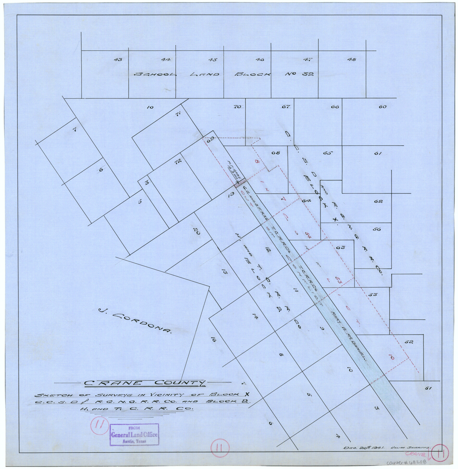
Crane County Working Sketch 11
Sketch of surveys in vicinity of Block X, C. C. S. D. & R. G. N. G. R.R. Co. and Block 2, H. & T. C. R.R. Co.
-
Map/Doc
68288
-
Collection
General Map Collection
-
Object Dates
12/20/1941 (Creation Date)
-
People and Organizations
William Shirriffs (Draftsman)
-
Counties
Crane
-
Subjects
Surveying Working Sketch
-
Height x Width
18.8 x 18.4 inches
47.8 x 46.7 cm
Part of: General Map Collection
Brazos Santiago

Print $20.00
- Digital $50.00
Brazos Santiago
1884
Size 24.4 x 18.2 inches
Map/Doc 73030
Crosby County Working Sketch 16

Print $40.00
- Digital $50.00
Crosby County Working Sketch 16
1979
Size 37.4 x 59.3 inches
Map/Doc 68450
Midland County Working Sketch 5

Print $20.00
- Digital $50.00
Midland County Working Sketch 5
1893
Size 31.2 x 25.6 inches
Map/Doc 70985

Menard County Working Sketch 6

Print $20.00
- Digital $50.00
Menard County Working Sketch 6
1924
Size 24.4 x 15.3 inches
Map/Doc 70953
Presidio County Sketch File U

Print $10.00
- Digital $50.00
Presidio County Sketch File U
1914
Size 10.2 x 8.2 inches
Map/Doc 34544
Terrell County Working Sketch 7

Print $20.00
- Digital $50.00
Terrell County Working Sketch 7
1915
Size 42.2 x 31.3 inches
Map/Doc 62156
Sketch of surveys in Shelby Co.

Print $2.00
- Digital $50.00
Sketch of surveys in Shelby Co.
1845
Size 6.4 x 8.8 inches
Map/Doc 69741
Padre Island National Seashore, Texas - Dependent Resurvey

Print $4.00
- Digital $50.00
Padre Island National Seashore, Texas - Dependent Resurvey
2001
Size 18.4 x 24.2 inches
Map/Doc 60543
Reagan County Sketch File 27

Print $8.00
- Digital $50.00
Reagan County Sketch File 27
1949
Size 11.4 x 8.7 inches
Map/Doc 35021
Martin County Working Sketch 18

Print $20.00
- Digital $50.00
Martin County Working Sketch 18
1982
Size 39.9 x 37.4 inches
Map/Doc 70836
Ward County Working Sketch 53

Print $40.00
- Digital $50.00
Ward County Working Sketch 53
1982
Size 37.0 x 53.4 inches
Map/Doc 72359
You may also like
[Texas and Pacific Railway Company, Block 44, Township One South]
![89846, [Texas and Pacific Railway Company, Block 44, Township One South], Twichell Survey Records](https://historictexasmaps.com/wmedia_w700/maps/89846-1.tif.jpg)
Print $40.00
- Digital $50.00
[Texas and Pacific Railway Company, Block 44, Township One South]
1912
Size 41.1 x 56.4 inches
Map/Doc 89846
The Republic County of Shelby. January 16, 1843

Print $20.00
The Republic County of Shelby. January 16, 1843
2020
Size 20.0 x 21.7 inches
Map/Doc 96285
Val Verde County Rolled Sketch 59

Print $20.00
- Digital $50.00
Val Verde County Rolled Sketch 59
1947
Size 45.2 x 23.6 inches
Map/Doc 10078
Schleicher County Working Sketch 3

Print $20.00
- Digital $50.00
Schleicher County Working Sketch 3
1914
Size 23.2 x 17.6 inches
Map/Doc 63805
Bowie County Rolled Sketch 6

Print $20.00
- Digital $50.00
Bowie County Rolled Sketch 6
1992
Size 11.3 x 18.1 inches
Map/Doc 5161
Crockett County Rolled Sketch 70

Print $20.00
- Digital $50.00
Crockett County Rolled Sketch 70
1949
Size 15.1 x 17.0 inches
Map/Doc 5612
Brazos River, Widths of Floodways/Brazos and Navasota Rivers

Print $20.00
- Digital $50.00
Brazos River, Widths of Floodways/Brazos and Navasota Rivers
1921
Size 38.1 x 24.5 inches
Map/Doc 65292
Hamilton County Working Sketch 6

Print $20.00
- Digital $50.00
Hamilton County Working Sketch 6
1942
Size 21.7 x 20.1 inches
Map/Doc 63344
Connected Map of Austin's Colony

Print $40.00
- Digital $50.00
Connected Map of Austin's Colony
1837
Size 93.2 x 43.1 inches
Map/Doc 93376
Real County Working Sketch 41

Print $20.00
- Digital $50.00
Real County Working Sketch 41
1952
Size 34.1 x 23.6 inches
Map/Doc 71933
Dallas County Sketch File 1

Print $4.00
- Digital $50.00
Dallas County Sketch File 1
1853
Size 7.2 x 7.0 inches
Map/Doc 20394
Travis County Appraisal District Plat Map 2_2915

Print $20.00
- Digital $50.00
Travis County Appraisal District Plat Map 2_2915
Size 21.5 x 26.4 inches
Map/Doc 94219