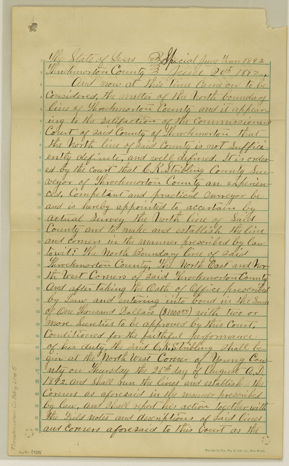
Throckmorton County Boundary File 5
Certificate of Bond filed May 29th, 93
-
Map/Doc
59286
-
Collection
General Map Collection
-
Counties
Throckmorton
-
Subjects
County Boundaries
-
Height x Width
14.3 x 8.9 inches
36.3 x 22.6 cm
Part of: General Map Collection
Harris County Sketch File 82

Print $20.00
- Digital $50.00
Harris County Sketch File 82
Size 19.6 x 25.3 inches
Map/Doc 11670
Brewster County Rolled Sketch 20

Print $20.00
- Digital $50.00
Brewster County Rolled Sketch 20
Size 31.4 x 28.2 inches
Map/Doc 5199
Hamilton County Working Sketch 30

Print $20.00
- Digital $50.00
Hamilton County Working Sketch 30
1982
Size 24.7 x 24.7 inches
Map/Doc 63368
[Surveys in Vehlein's Colony along the San Jacinto River]
![27, [Surveys in Vehlein's Colony along the San Jacinto River], General Map Collection](https://historictexasmaps.com/wmedia_w700/maps/27.tif.jpg)
Print $20.00
- Digital $50.00
[Surveys in Vehlein's Colony along the San Jacinto River]
1837
Size 19.4 x 15.7 inches
Map/Doc 27
Randall County Rolled Sketch 2

Print $20.00
- Digital $50.00
Randall County Rolled Sketch 2
1941
Size 31.9 x 23.9 inches
Map/Doc 7422
Kendall County Sketch File 4

Print $4.00
- Digital $50.00
Kendall County Sketch File 4
Size 7.8 x 8.6 inches
Map/Doc 28684
Harris County Sketch File 31

Print $6.00
- Digital $50.00
Harris County Sketch File 31
Size 14.0 x 8.9 inches
Map/Doc 25426
Coryell County Sketch File 4

Print $6.00
- Digital $50.00
Coryell County Sketch File 4
1854
Size 12.8 x 8.2 inches
Map/Doc 19342
Glasscock County Sketch File 12

Print $5.00
- Digital $50.00
Glasscock County Sketch File 12
1935
Size 14.1 x 9.2 inches
Map/Doc 24176
Map of Castro County

Print $20.00
- Digital $50.00
Map of Castro County
1900
Size 41.9 x 34.4 inches
Map/Doc 4748
Travis County Sketch File 39

Print $20.00
- Digital $50.00
Travis County Sketch File 39
1914
Size 15.5 x 25.7 inches
Map/Doc 12463
Brewster County Sketch File N-3

Print $6.00
- Digital $50.00
Brewster County Sketch File N-3
1882
Size 8.6 x 7.6 inches
Map/Doc 15589
You may also like
Flight Mission No. DIX-10P, Frame 177, Aransas County

Print $20.00
- Digital $50.00
Flight Mission No. DIX-10P, Frame 177, Aransas County
1956
Size 18.6 x 22.3 inches
Map/Doc 83967
Menard County Working Sketch 11

Print $20.00
- Digital $50.00
Menard County Working Sketch 11
1939
Size 23.1 x 24.9 inches
Map/Doc 70958
Kinney County Sketch File 5

Print $2.00
- Digital $50.00
Kinney County Sketch File 5
Size 5.7 x 13.1 inches
Map/Doc 29123
Newton County Sketch File 24

Print $4.00
- Digital $50.00
Newton County Sketch File 24
1881
Size 8.4 x 8.1 inches
Map/Doc 32405
Flight Mission No. DCL-6C, Frame 29, Kenedy County

Print $20.00
- Digital $50.00
Flight Mission No. DCL-6C, Frame 29, Kenedy County
1943
Size 18.6 x 22.4 inches
Map/Doc 85886
Flight Mission No. DCL-5C, Frame 75, Kenedy County

Print $20.00
- Digital $50.00
Flight Mission No. DCL-5C, Frame 75, Kenedy County
1943
Size 18.6 x 22.2 inches
Map/Doc 85858
Carta Particular de las Costas Setentrionales del Seno Mexicano que comprehende las de la Florida Ocidental las Margenes de la Luisiana y toda la rivera que sigue por la Bahía de San Bernardo y el Río Bravo del Norte hasta la Laguna Madre

Carta Particular de las Costas Setentrionales del Seno Mexicano que comprehende las de la Florida Ocidental las Margenes de la Luisiana y toda la rivera que sigue por la Bahía de San Bernardo y el Río Bravo del Norte hasta la Laguna Madre
1825
Size 26.1 x 38.7 inches
Map/Doc 94568
Brewster County Rolled Sketch 104

Print $40.00
- Digital $50.00
Brewster County Rolled Sketch 104
1938
Size 68.3 x 45.3 inches
Map/Doc 8511
Railroad Track Map, T&PRRCo., Culberson County, Texas

Print $4.00
- Digital $50.00
Railroad Track Map, T&PRRCo., Culberson County, Texas
1910
Size 11.8 x 18.5 inches
Map/Doc 62827
Callahan County Sketch File 14

Print $40.00
- Digital $50.00
Callahan County Sketch File 14
1938
Size 20.5 x 26.1 inches
Map/Doc 11042
Terry County Sketch File 9

Print $4.00
- Digital $50.00
Terry County Sketch File 9
1917
Size 14.4 x 8.8 inches
Map/Doc 38032
Packery Channel

Print $3.00
- Digital $50.00
Packery Channel
1972
Size 10.6 x 17.8 inches
Map/Doc 2999