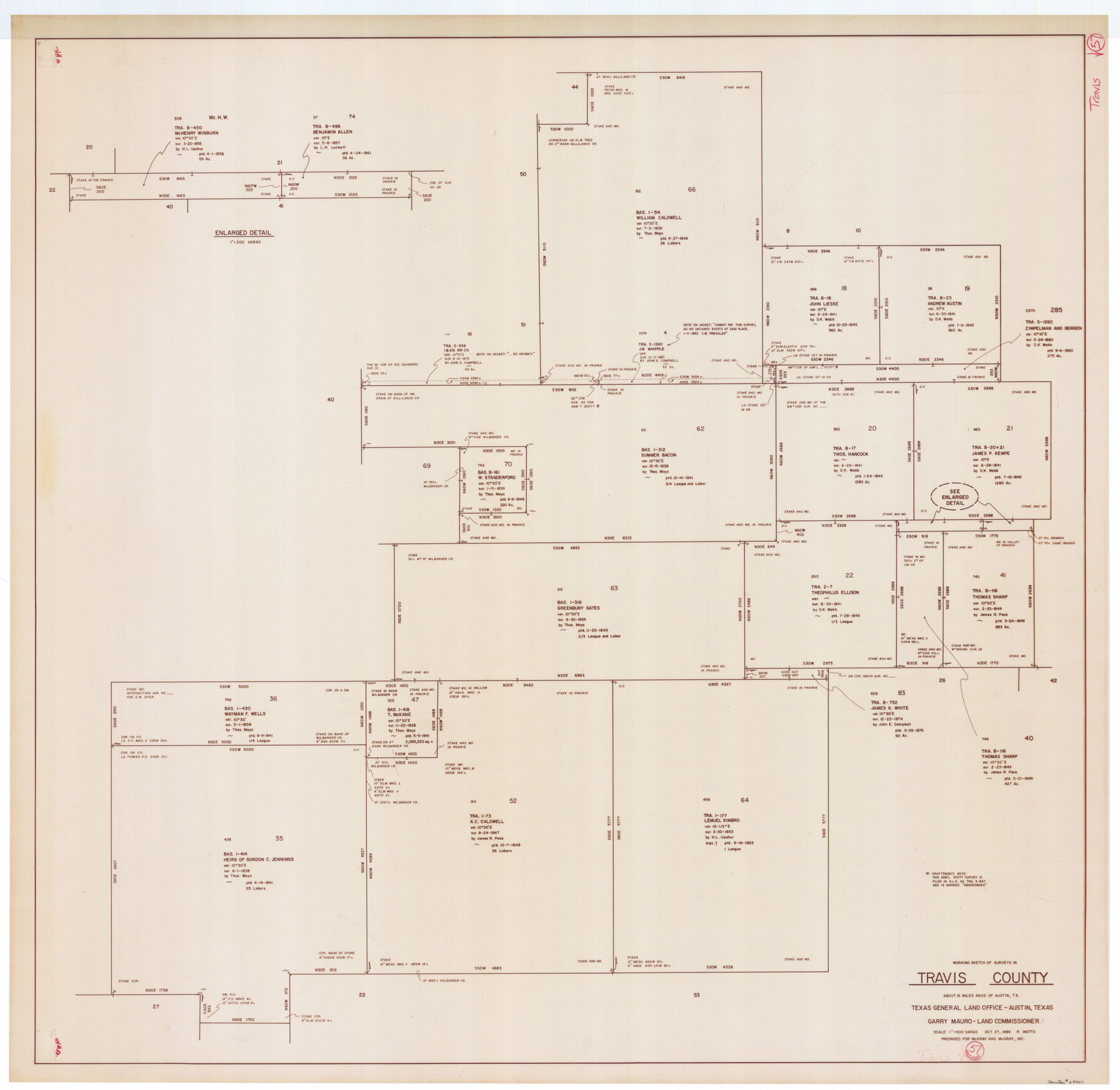
Travis County Working Sketch 57
-
Map/Doc
69441
-
Collection
General Map Collection
-
Object Dates
10/27/1989 (Creation Date)
-
People and Organizations
R. Watts (Draftsman)
-
Counties
Travis
-
Subjects
Surveying Working Sketch
-
Height x Width
42.8 x 44.0 inches
108.7 x 111.8 cm
-
Scale
1" = 500 varas
Part of: General Map Collection
Hockley County Sketch File 3

Print $20.00
- Digital $50.00
Hockley County Sketch File 3
Size 43.1 x 35.4 inches
Map/Doc 10490
Brewster County Rolled Sketch 52

Print $20.00
- Digital $50.00
Brewster County Rolled Sketch 52
1930
Size 15.3 x 41.4 inches
Map/Doc 61782
Newton County Rolled Sketch 12

Print $40.00
- Digital $50.00
Newton County Rolled Sketch 12
1952
Size 38.4 x 56.1 inches
Map/Doc 9577
Atascosa County Rolled Sketch 5B2

Print $20.00
- Digital $50.00
Atascosa County Rolled Sketch 5B2
1910
Size 16.4 x 12.5 inches
Map/Doc 5091
Flight Mission No. BQR-4K, Frame 70, Brazoria County

Print $20.00
- Digital $50.00
Flight Mission No. BQR-4K, Frame 70, Brazoria County
1952
Size 18.8 x 22.4 inches
Map/Doc 84003
Dickens County Sketch File 14a

Print $20.00
- Digital $50.00
Dickens County Sketch File 14a
Size 18.2 x 16.5 inches
Map/Doc 11321

Harris County Working Sketch 30

Print $20.00
- Digital $50.00
Harris County Working Sketch 30
1935
Size 25.9 x 28.0 inches
Map/Doc 65922
Upton County Working Sketch 52

Print $20.00
- Digital $50.00
Upton County Working Sketch 52
1983
Size 20.9 x 20.2 inches
Map/Doc 69549

McCulloch County

Print $40.00
- Digital $50.00
McCulloch County
1949
Size 48.4 x 37.5 inches
Map/Doc 95584
Crosby County Boundary File 4

Print $88.00
- Digital $50.00
Crosby County Boundary File 4
Size 14.8 x 9.1 inches
Map/Doc 52003
You may also like
Gaines County Working Sketch 25

Print $20.00
- Digital $50.00
Gaines County Working Sketch 25
1983
Size 37.5 x 38.4 inches
Map/Doc 69325
General Highway Map, Trinity County, Texas

Print $20.00
General Highway Map, Trinity County, Texas
1961
Size 18.1 x 24.5 inches
Map/Doc 79688
Dallas County Working Sketch 2

Print $20.00
- Digital $50.00
Dallas County Working Sketch 2
1917
Size 18.2 x 19.0 inches
Map/Doc 68568
Edwards County Working Sketch 42

Print $20.00
- Digital $50.00
Edwards County Working Sketch 42
1949
Size 25.5 x 31.4 inches
Map/Doc 68918
Polk County Working Sketch 24

Print $20.00
- Digital $50.00
Polk County Working Sketch 24
1957
Size 24.8 x 25.3 inches
Map/Doc 71640
Dimmit County Sketch File 56

Print $20.00
- Digital $50.00
Dimmit County Sketch File 56
1939
Size 15.8 x 27.4 inches
Map/Doc 11360
Flight Mission No. BQY-15M, Frame 4, Harris County

Print $20.00
- Digital $50.00
Flight Mission No. BQY-15M, Frame 4, Harris County
1953
Size 18.6 x 22.4 inches
Map/Doc 85302
Brewster County Rolled Sketch 113

Print $171.00
- Digital $50.00
Brewster County Rolled Sketch 113
1975
Map/Doc 9565
Coryell County Working Sketch 23

Print $20.00
- Digital $50.00
Coryell County Working Sketch 23
1977
Size 27.6 x 30.6 inches
Map/Doc 68230
Val Verde County Sketch File 25

Print $20.00
- Digital $50.00
Val Verde County Sketch File 25
Size 19.8 x 24.6 inches
Map/Doc 12572
Hutchinson County Working Sketch 6

Print $20.00
- Digital $50.00
Hutchinson County Working Sketch 6
1914
Size 20.2 x 29.0 inches
Map/Doc 66364
Flight Mission No. CGI-3N, Frame 124, Cameron County

Print $20.00
- Digital $50.00
Flight Mission No. CGI-3N, Frame 124, Cameron County
1954
Size 18.5 x 22.2 inches
Map/Doc 84597