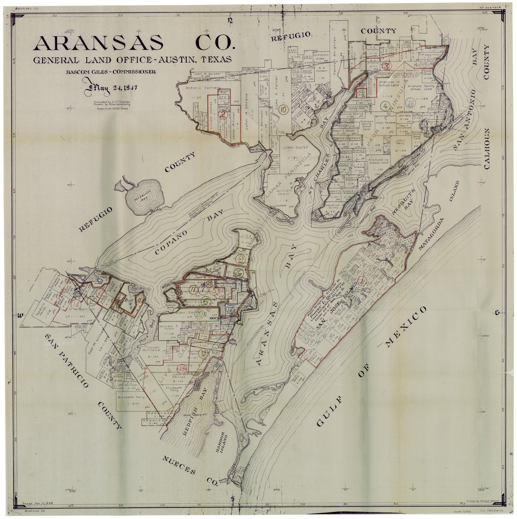
Aransas County Working Sketch Graphic Index
-
Map/Doc
76455
-
Collection
General Map Collection
-
Object Dates
5/24/1947 (Creation Date)
-
People and Organizations
G.C. Morriss (Compiler)
Eltea Armstrong (Draftsman)
-
Counties
Aransas
-
Subjects
County Surveying Working Sketch
-
Height x Width
36.8 x 36.6 inches
93.5 x 93.0 cm
-
Scale
1" = 2000 varas
Part of: General Map Collection
Etats-Unis de l'Amérique Septentrionale avec les Isles Royale, de Terre Neuve de St. Jean, L'Acadie &c.

Print $20.00
- Digital $50.00
Etats-Unis de l'Amérique Septentrionale avec les Isles Royale, de Terre Neuve de St. Jean, L'Acadie &c.
1785
Size 20.9 x 28.2 inches
Map/Doc 93679
Hall County Sketch File 13

Print $20.00
- Digital $50.00
Hall County Sketch File 13
Size 15.7 x 24.2 inches
Map/Doc 11606
Orange County Working Sketch 7

Print $20.00
- Digital $50.00
Orange County Working Sketch 7
1922
Size 21.9 x 31.9 inches
Map/Doc 71339
Collingsworth County Working Sketch 2

Print $20.00
- Digital $50.00
Collingsworth County Working Sketch 2
1957
Size 42.5 x 20.1 inches
Map/Doc 63761
El Paso County Boundary File 5

Print $80.00
- Digital $50.00
El Paso County Boundary File 5
Size 34.7 x 48.4 inches
Map/Doc 53078
Orange County Rolled Sketch 23

Print $20.00
- Digital $50.00
Orange County Rolled Sketch 23
1950
Size 29.0 x 35.3 inches
Map/Doc 7185
Galveston County NRC Article 33.136 Sketch 48

Print $22.00
- Digital $50.00
Galveston County NRC Article 33.136 Sketch 48
2006
Size 24.4 x 36.7 inches
Map/Doc 88611
[Sketch for Mineral Application 13440]
![2799, [Sketch for Mineral Application 13440], General Map Collection](https://historictexasmaps.com/wmedia_w700/maps/2799-1.tif.jpg)
Print $20.00
- Digital $50.00
[Sketch for Mineral Application 13440]
1925
Size 24.3 x 54.0 inches
Map/Doc 2799
Flight Mission No. CRC-2R, Frame 133, Chambers County

Print $20.00
- Digital $50.00
Flight Mission No. CRC-2R, Frame 133, Chambers County
1956
Size 18.7 x 22.5 inches
Map/Doc 84749
Culberson County Sketch File 10

Print $4.00
- Digital $50.00
Culberson County Sketch File 10
1911
Size 14.6 x 9.0 inches
Map/Doc 20144
Flight Mission No. BRE-1P, Frame 142, Nueces County

Print $20.00
- Digital $50.00
Flight Mission No. BRE-1P, Frame 142, Nueces County
1956
Size 18.4 x 22.3 inches
Map/Doc 86702
Kleberg County Rolled Sketch 10-7

Print $20.00
- Digital $50.00
Kleberg County Rolled Sketch 10-7
1953
Size 37.3 x 34.5 inches
Map/Doc 9401
You may also like
Town of Ropes Hockley County, Texas

Print $20.00
- Digital $50.00
Town of Ropes Hockley County, Texas
Size 29.3 x 28.7 inches
Map/Doc 92222
The Republic County of Gonzales. Spring 1842

Print $20.00
The Republic County of Gonzales. Spring 1842
2020
Size 14.7 x 21.7 inches
Map/Doc 96159
Mason County Working Sketch 23

Print $20.00
- Digital $50.00
Mason County Working Sketch 23
2004
Size 17.4 x 36.9 inches
Map/Doc 83577
[Surveys in the Bexar District along Borrego Creek prepared by the Deputy Surveyor]
![96, [Surveys in the Bexar District along Borrego Creek prepared by the Deputy Surveyor], General Map Collection](https://historictexasmaps.com/wmedia_w700/maps/96.tif.jpg)
Print $2.00
- Digital $50.00
[Surveys in the Bexar District along Borrego Creek prepared by the Deputy Surveyor]
1847
Size 7.7 x 7.2 inches
Map/Doc 96
Hutchinson County Sketch File 44a

Print $4.00
- Digital $50.00
Hutchinson County Sketch File 44a
1989
Size 11.2 x 8.7 inches
Map/Doc 27352
Callahan County Working Sketch 3

Print $20.00
- Digital $50.00
Callahan County Working Sketch 3
1952
Size 35.3 x 30.5 inches
Map/Doc 67885
Stonewall County Working Sketch 34

Print $20.00
- Digital $50.00
Stonewall County Working Sketch 34
1985
Size 34.0 x 33.9 inches
Map/Doc 62341
Clay County Working Sketch 8

Print $20.00
- Digital $50.00
Clay County Working Sketch 8
1937
Size 23.1 x 22.0 inches
Map/Doc 68031
Comanche County Sketch File 20a

Print $2.00
- Digital $50.00
Comanche County Sketch File 20a
Size 12.9 x 8.2 inches
Map/Doc 19105
Wavell Empresario Colony. Proposed, March 9, 1826

Print $20.00
Wavell Empresario Colony. Proposed, March 9, 1826
2020
Size 16.0 x 21.7 inches
Map/Doc 96009
Culberson County Rolled Sketch 30

Print $84.00
- Digital $50.00
Culberson County Rolled Sketch 30
1928
Size 57.1 x 36.1 inches
Map/Doc 8746
Flight Mission No. DAG-21K, Frame 31, Matagorda County

Print $20.00
- Digital $50.00
Flight Mission No. DAG-21K, Frame 31, Matagorda County
1952
Size 18.7 x 22.4 inches
Map/Doc 86398