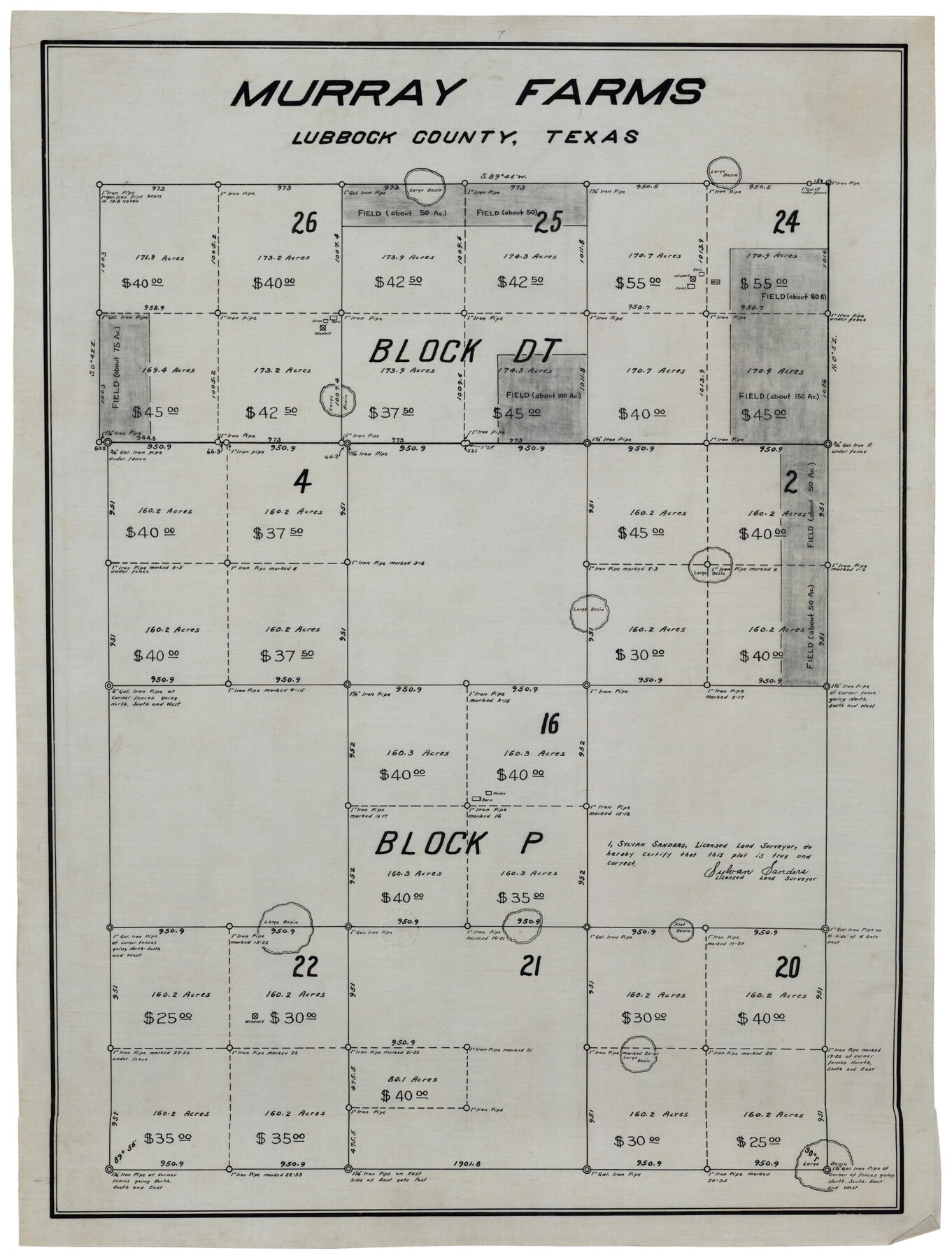
Murray Farms
-
Map/Doc
92866
-
Collection
Twichell Survey Records
-
People and Organizations
Sylvan Sanders (Surveyor/Engineer)
-
Counties
Lubbock
-
Height x Width
15.5 x 20.3 inches
39.4 x 51.6 cm
Part of: Twichell Survey Records
Working Sketch in Stephens County

Print $20.00
- Digital $50.00
Working Sketch in Stephens County
1919
Size 15.4 x 18.6 inches
Map/Doc 91912
[County School Land for Shackelford, Reeves, Hardeman, Val Verde, Hood, Martin, Rusk, Atascosa, and Edwards Counties]
![91100, [County School Land for Shackelford, Reeves, Hardeman, Val Verde, Hood, Martin, Rusk, Atascosa, and Edwards Counties], Twichell Survey Records](https://historictexasmaps.com/wmedia_w700/maps/91100-1.tif.jpg)
Print $2.00
- Digital $50.00
[County School Land for Shackelford, Reeves, Hardeman, Val Verde, Hood, Martin, Rusk, Atascosa, and Edwards Counties]
Size 7.5 x 6.4 inches
Map/Doc 91100
Survey of Improvements on Meeks Gin Site Town of Ropes Hockley County, Texas

Print $20.00
- Digital $50.00
Survey of Improvements on Meeks Gin Site Town of Ropes Hockley County, Texas
1957
Size 13.0 x 17.6 inches
Map/Doc 92214
Working Sketch from Crosby and Garza Cos.

Print $20.00
- Digital $50.00
Working Sketch from Crosby and Garza Cos.
1902
Size 28.7 x 38.7 inches
Map/Doc 90794

Block 1 H&GN RR Co.

Print $20.00
- Digital $50.00
Block 1 H&GN RR Co.
Size 39.3 x 40.3 inches
Map/Doc 89769

Sketch Showing Correction of Field Notes and Surveys

Print $3.00
- Digital $50.00
Sketch Showing Correction of Field Notes and Surveys
1886
Size 13.0 x 10.8 inches
Map/Doc 90270

[Connecting lines through Blocks A2, 29, I, GG, I. & G. N. Block 1 and Archer County School Land]
![91646, [Connecting lines through Blocks A2, 29, I, GG, I. & G. N. Block 1 and Archer County School Land], Twichell Survey Records](https://historictexasmaps.com/wmedia_w700/maps/91646-1.tif.jpg)
Print $20.00
- Digital $50.00
[Connecting lines through Blocks A2, 29, I, GG, I. & G. N. Block 1 and Archer County School Land]
Size 26.2 x 18.8 inches
Map/Doc 91646
[Connections of Blocks C-17, B-59, T6 and C-11]
![93067, [Connections of Blocks C-17, B-59, T6 and C-11], Twichell Survey Records](https://historictexasmaps.com/wmedia_w700/maps/93067-1.tif.jpg)
Print $20.00
- Digital $50.00
[Connections of Blocks C-17, B-59, T6 and C-11]
Size 31.2 x 28.0 inches
Map/Doc 93067
[Sections 58-70, I. & G. N. Block 1, Runnels County School Land and part of Block 194]
![91632, [Sections 58-70, I. & G. N. Block 1, Runnels County School Land and part of Block 194], Twichell Survey Records](https://historictexasmaps.com/wmedia_w700/maps/91632-1.tif.jpg)
Print $20.00
- Digital $50.00
[Sections 58-70, I. & G. N. Block 1, Runnels County School Land and part of Block 194]
Size 23.9 x 20.9 inches
Map/Doc 91632
You may also like
Bexar County Sketch File 49

Print $8.00
- Digital $50.00
Bexar County Sketch File 49
1874
Size 12.6 x 8.3 inches
Map/Doc 14530
Old Miscellaneous File 19

Print $32.00
- Digital $50.00
Old Miscellaneous File 19
Size 14.2 x 8.8 inches
Map/Doc 75499
General Highway Map, McLennan County, Texas

Print $20.00
General Highway Map, McLennan County, Texas
1961
Size 18.2 x 24.6 inches
Map/Doc 79589
Potter County

Print $20.00
- Digital $50.00
Potter County
1960
Size 40.0 x 32.3 inches
Map/Doc 77397
Current Miscellaneous File 111

Print $8.00
- Digital $50.00
Current Miscellaneous File 111
1996
Size 11.3 x 8.7 inches
Map/Doc 74714
Edwards County Sketch File 16a

Print $24.00
- Digital $50.00
Edwards County Sketch File 16a
1903
Size 14.3 x 8.8 inches
Map/Doc 21720
Tarrant County Sketch File 35

Print $50.00
Tarrant County Sketch File 35
2018
Size 11.0 x 8.5 inches
Map/Doc 95394
Flight Mission No. DIX-6P, Frame 134, Aransas County

Print $20.00
- Digital $50.00
Flight Mission No. DIX-6P, Frame 134, Aransas County
1956
Size 18.8 x 22.4 inches
Map/Doc 83840
Bexar County Sketch File 9

Print $4.00
- Digital $50.00
Bexar County Sketch File 9
1853
Size 8.2 x 13.2 inches
Map/Doc 14479
Gaines County, Texas

Print $40.00
- Digital $50.00
Gaines County, Texas
1915
Size 54.1 x 33.0 inches
Map/Doc 89843
[H. & G. N. Blocks 1-4 and Blocks C-19, C-20, 54, 55 and 56]
![91781, [H. & G. N. Blocks 1-4 and Blocks C-19, C-20, 54, 55 and 56], Twichell Survey Records](https://historictexasmaps.com/wmedia_w700/maps/91781-1.tif.jpg)
Print $20.00
- Digital $50.00
[H. & G. N. Blocks 1-4 and Blocks C-19, C-20, 54, 55 and 56]
Size 23.3 x 29.3 inches
Map/Doc 91781
El Paso County Working Sketch 22

Print $20.00
- Digital $50.00
El Paso County Working Sketch 22
1961
Size 21.6 x 20.0 inches
Map/Doc 69044