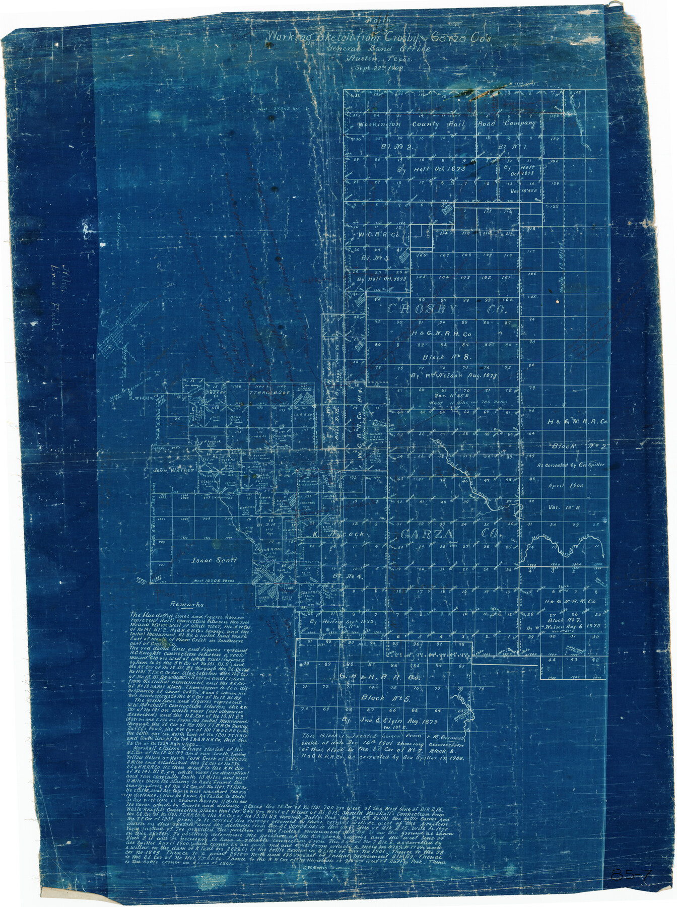
Working Sketch from Crosby and Garza Cos.
85-7
-
Map/Doc
90794
-
Collection
Twichell Survey Records
-
Object Dates
1902/9/22 (Creation Date)
-
People and Organizations
J.W. Morris (Draftsman)
-
Counties
Garza Crosby
-
Height x Width
28.7 x 38.7 inches
72.9 x 98.3 cm
Part of: Twichell Survey Records
Working Sketch Hutchinson County

Print $20.00
- Digital $50.00
Working Sketch Hutchinson County
1925
Size 30.0 x 20.6 inches
Map/Doc 92167
Englewood Cemetery Slaton, Texas

Print $20.00
- Digital $50.00
Englewood Cemetery Slaton, Texas
1947
Size 24.4 x 35.2 inches
Map/Doc 92838
[Texas Boundary Line]
![92069, [Texas Boundary Line], Twichell Survey Records](https://historictexasmaps.com/wmedia_w700/maps/92069-1.tif.jpg)
Print $20.00
- Digital $50.00
[Texas Boundary Line]
Size 31.8 x 18.1 inches
Map/Doc 92069
[Part of North line of County, North of Block G]
![90805, [Part of North line of County, North of Block G], Twichell Survey Records](https://historictexasmaps.com/wmedia_w700/maps/90805-1.tif.jpg)
Print $20.00
- Digital $50.00
[Part of North line of County, North of Block G]
Size 17.6 x 12.1 inches
Map/Doc 90805
Re-Subdivision of a Part of E. Dick Slaughter Lands Cochran County, Texas

Print $20.00
- Digital $50.00
Re-Subdivision of a Part of E. Dick Slaughter Lands Cochran County, Texas
Size 31.0 x 21.9 inches
Map/Doc 92482
Block 34, Township 5 South

Print $3.00
- Digital $50.00
Block 34, Township 5 South
1876
Size 9.6 x 9.6 inches
Map/Doc 90752
[T. H. Jones Blk. O, Blk. F, Coyote Lake Area, Sutton County School Land Leagues]
![90246, [T. H. Jones Blk. O, Blk. F, Coyote Lake Area, Sutton County School Land Leagues], Twichell Survey Records](https://historictexasmaps.com/wmedia_w700/maps/90246-1.tif.jpg)
Print $20.00
- Digital $50.00
[T. H. Jones Blk. O, Blk. F, Coyote Lake Area, Sutton County School Land Leagues]
Size 21.0 x 33.6 inches
Map/Doc 90246
Deaf Smith County

Print $20.00
- Digital $50.00
Deaf Smith County
1888
Size 28.7 x 19.8 inches
Map/Doc 90598
Steele Addition, Seagraves, Texas

Print $20.00
- Digital $50.00
Steele Addition, Seagraves, Texas
Size 17.4 x 26.3 inches
Map/Doc 92655
Crockett County, Texas

Print $20.00
- Digital $50.00
Crockett County, Texas
Size 39.8 x 30.8 inches
Map/Doc 92547
[Blueprint of unknown Block/Surveys]
![92139, [Blueprint of unknown Block/Surveys], Twichell Survey Records](https://historictexasmaps.com/wmedia_w700/maps/92139-1.tif.jpg)
Print $20.00
- Digital $50.00
[Blueprint of unknown Block/Surveys]
Size 24.7 x 26.8 inches
Map/Doc 92139
Mrs. W. H. Bledsoe Farm NE 100.2 Acres of Section 37, Block AK

Print $2.00
- Digital $50.00
Mrs. W. H. Bledsoe Farm NE 100.2 Acres of Section 37, Block AK
Size 10.6 x 9.2 inches
Map/Doc 92283
You may also like
Flight Mission No. DAG-21K, Frame 125, Matagorda County

Print $20.00
- Digital $50.00
Flight Mission No. DAG-21K, Frame 125, Matagorda County
1952
Size 18.5 x 22.4 inches
Map/Doc 86451
Liberty County Sketch File 22

Print $10.00
- Digital $50.00
Liberty County Sketch File 22
1860
Size 14.0 x 9.8 inches
Map/Doc 29930
Outer Continental Shelf Leasing Maps (Louisiana Offshore Operations)

Print $20.00
- Digital $50.00
Outer Continental Shelf Leasing Maps (Louisiana Offshore Operations)
1959
Size 18.3 x 14.5 inches
Map/Doc 76112
Webb County Sketch File B

Print $20.00
- Digital $50.00
Webb County Sketch File B
Size 15.9 x 13.7 inches
Map/Doc 12605
Liberty County Working Sketch 22

Print $20.00
- Digital $50.00
Liberty County Working Sketch 22
1941
Size 19.6 x 26.1 inches
Map/Doc 70481
Victoria County, Texas

Print $20.00
- Digital $50.00
Victoria County, Texas
1879
Size 26.5 x 22.8 inches
Map/Doc 511
Improving Sabine Pass, Texas. Surveyed May 10th to June 30th, 1894 under the direction of Major James B. Quinn, Corps of Engineers, USA

Print $20.00
- Digital $50.00
Improving Sabine Pass, Texas. Surveyed May 10th to June 30th, 1894 under the direction of Major James B. Quinn, Corps of Engineers, USA
1894
Size 9.3 x 13.2 inches
Map/Doc 94155
Crockett County Working Sketch 85

Print $40.00
- Digital $50.00
Crockett County Working Sketch 85
1976
Size 23.4 x 54.8 inches
Map/Doc 68418
Martin County Working Sketch 4

Print $20.00
- Digital $50.00
Martin County Working Sketch 4
1953
Size 22.9 x 42.7 inches
Map/Doc 70822
Revised map of Jefferson County, Texas showing land surveys, railroads and water ways

Print $20.00
- Digital $50.00
Revised map of Jefferson County, Texas showing land surveys, railroads and water ways
1898
Size 27.2 x 24.1 inches
Map/Doc 95912
Blanco County Sketch File 45

Print $4.00
- Digital $50.00
Blanco County Sketch File 45
1934
Size 7.8 x 7.6 inches
Map/Doc 14671
Flight Mission No. BQR-5K, Frame 68, Brazoria County

Print $20.00
- Digital $50.00
Flight Mission No. BQR-5K, Frame 68, Brazoria County
1952
Size 18.8 x 22.5 inches
Map/Doc 84013