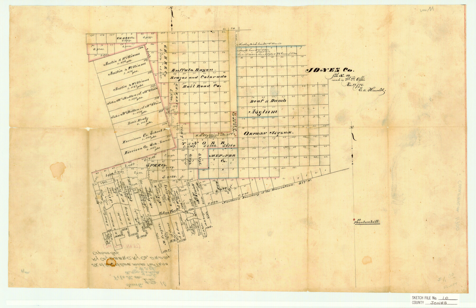
Jones County Sketch File 10
Sk. of Blks. of Surs. Made for T&NO Ry. Co., BBB&C Ry. Co., D&D Asy. Orphan Asy.
-
Map/Doc
11900
-
Collection
General Map Collection
-
Object Dates
11/2/1875 (Creation Date)
11/2/1875 (File Date)
-
People and Organizations
E.A. Hensolds (Surveyor/Engineer)
-
Counties
Jones
-
Subjects
Surveying Sketch File
-
Height x Width
14.3 x 22.2 inches
36.3 x 56.4 cm
-
Medium
paper, manuscript
-
Features
Ft. Phantom Hill
Elm Fork
Part of: General Map Collection
Northeast Part of Webb County

Print $20.00
- Digital $50.00
Northeast Part of Webb County
1986
Size 34.6 x 45.7 inches
Map/Doc 77452
Louisiana and Texas Intracoastal Waterway

Print $20.00
- Digital $50.00
Louisiana and Texas Intracoastal Waterway
Size 13.9 x 19.0 inches
Map/Doc 83347
Williamson County Sketch File 21

Print $4.00
- Digital $50.00
Williamson County Sketch File 21
1893
Size 11.3 x 8.7 inches
Map/Doc 40350
Webb County Rolled Sketch 29

Print $20.00
- Digital $50.00
Webb County Rolled Sketch 29
1932
Size 16.5 x 15.3 inches
Map/Doc 8187
Flight Mission No. CUG-3P, Frame 82, Kleberg County

Print $20.00
- Digital $50.00
Flight Mission No. CUG-3P, Frame 82, Kleberg County
1956
Size 18.6 x 22.2 inches
Map/Doc 86257
Matagorda County Rolled Sketch 40

Print $20.00
- Digital $50.00
Matagorda County Rolled Sketch 40
Size 24.6 x 27.4 inches
Map/Doc 6704
Edwards County Working Sketch 33

Print $40.00
- Digital $50.00
Edwards County Working Sketch 33
1947
Size 42.6 x 50.2 inches
Map/Doc 68909
Part of Laguna Madre in Cameron County, showing Subdivision for Mineral Development

Print $20.00
- Digital $50.00
Part of Laguna Madre in Cameron County, showing Subdivision for Mineral Development
1963
Size 45.8 x 36.0 inches
Map/Doc 1926
Gaines County Sketch File 2a

Print $16.00
- Digital $50.00
Gaines County Sketch File 2a
Size 9.0 x 8.9 inches
Map/Doc 23167
G. C. & S. F. Ry. Alinement [sic] and Right of Way Map of Dallas Branch, Johnson County, Texas
![64650, G. C. & S. F. Ry. Alinement [sic] and Right of Way Map of Dallas Branch, Johnson County, Texas, General Map Collection](https://historictexasmaps.com/wmedia_w700/maps/64650.tif.jpg)
Print $40.00
- Digital $50.00
G. C. & S. F. Ry. Alinement [sic] and Right of Way Map of Dallas Branch, Johnson County, Texas
1925
Size 38.0 x 125.2 inches
Map/Doc 64650
McMullen County Sketch File 26

Print $20.00
- Digital $50.00
McMullen County Sketch File 26
1884
Size 14.7 x 19.8 inches
Map/Doc 12060
Marion County Working Sketch 39

Print $20.00
- Digital $50.00
Marion County Working Sketch 39
1991
Size 20.8 x 19.2 inches
Map/Doc 70815
You may also like
Kimble County Working Sketch 75

Print $20.00
- Digital $50.00
Kimble County Working Sketch 75
1968
Size 32.0 x 35.7 inches
Map/Doc 70143
Interpretative map of wind erodibility. Gaines County, Texas

Interpretative map of wind erodibility. Gaines County, Texas
1986
Size 27.6 x 36.2 inches
Map/Doc 93561
Frio County Rolled Sketch 16

Print $20.00
- Digital $50.00
Frio County Rolled Sketch 16
1952
Size 38.4 x 40.7 inches
Map/Doc 8906
Right-of-Way and Track Map, Houston and Brazos Valley Ry. Co. operated by the Houston and Brazos Valley Ry. Co.

Print $40.00
- Digital $50.00
Right-of-Way and Track Map, Houston and Brazos Valley Ry. Co. operated by the Houston and Brazos Valley Ry. Co.
1918
Size 24.9 x 56.5 inches
Map/Doc 64608
Flight Mission No. BRA-8M, Frame 83, Jefferson County

Print $20.00
- Digital $50.00
Flight Mission No. BRA-8M, Frame 83, Jefferson County
1953
Size 15.8 x 15.7 inches
Map/Doc 85603
Haskell County Working Sketch 17

Print $20.00
- Digital $50.00
Haskell County Working Sketch 17
2011
Size 34.3 x 32.3 inches
Map/Doc 89989
Denton County Sketch File 42

Print $4.00
- Digital $50.00
Denton County Sketch File 42
1960
Size 11.4 x 8.9 inches
Map/Doc 20792
Jefferson County Sketch File 13

Print $6.00
- Digital $50.00
Jefferson County Sketch File 13
Size 14.9 x 9.3 inches
Map/Doc 28147
Topography and water depth as shown by the U.S. Coast Survey of 1888

Print $20.00
- Digital $50.00
Topography and water depth as shown by the U.S. Coast Survey of 1888
1890
Size 17.0 x 18.8 inches
Map/Doc 390
Reeves County Sketch File 5

Print $20.00
- Digital $50.00
Reeves County Sketch File 5
Size 16.1 x 33.4 inches
Map/Doc 12241
Howard County, Texas

Print $20.00
- Digital $50.00
Howard County, Texas
1870
Size 22.7 x 17.9 inches
Map/Doc 733
Flight Mission No. DCL-7C, Frame 48, Kenedy County

Print $20.00
- Digital $50.00
Flight Mission No. DCL-7C, Frame 48, Kenedy County
1943
Size 16.6 x 16.5 inches
Map/Doc 86036