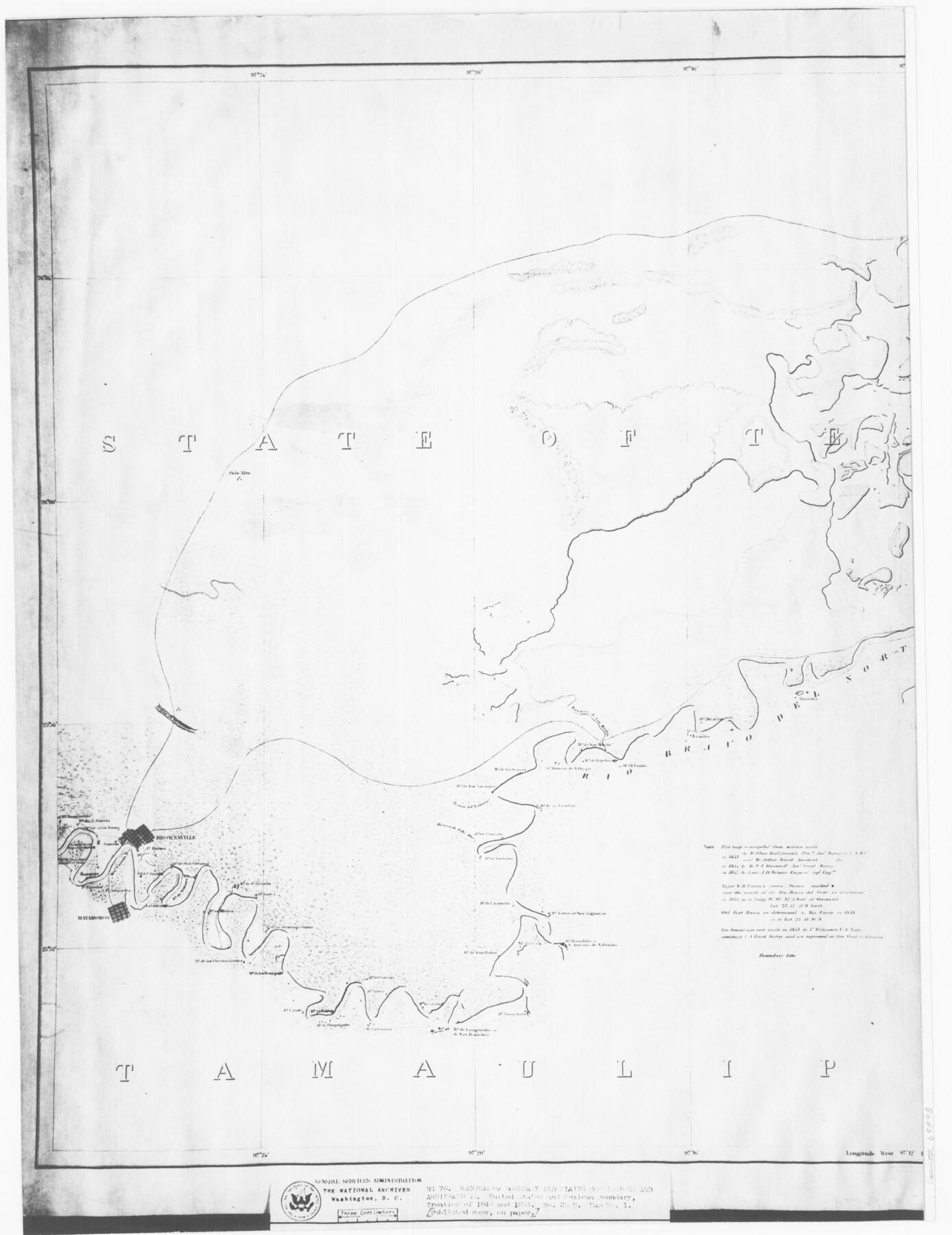
Boundary Between the United States & Mexico Agreed Upon by the Joint Commission under the Treaty of Guadalupe Hidalgo
K-7-67c; K.7.67d
-
Map/Doc
65395
-
Collection
General Map Collection
-
Object Dates
1853 (Creation Date)
-
People and Organizations
F. Herbst (Draftsman)
Arthur Schott (Surveyor/Engineer)
Chas. Radziminski (Surveyor/Engineer)
W.H. Emory (Surveyor/Engineer)
-
Counties
Cameron
-
Subjects
Texas Boundaries
-
Height x Width
24.4 x 18.8 inches
62.0 x 47.8 cm
-
Comments
A composite map of the mouth of the Rio Grande.
From the National Archives, Washington D. C.
Part of: General Map Collection
Copy of Surveyor's Field Book, Morris Browning - In Blocks 7, 5 & 4, I&GNRRCo., Hutchinson and Carson Counties, Texas

Print $2.00
- Digital $50.00
Copy of Surveyor's Field Book, Morris Browning - In Blocks 7, 5 & 4, I&GNRRCo., Hutchinson and Carson Counties, Texas
1888
Size 8.9 x 7.1 inches
Map/Doc 62287
El Paso County Sketch File 1a

Print $4.00
- Digital $50.00
El Paso County Sketch File 1a
Size 12.1 x 8.2 inches
Map/Doc 21907
Hopkins County Sketch File 16

Print $4.00
- Digital $50.00
Hopkins County Sketch File 16
1870
Size 8.1 x 10.1 inches
Map/Doc 26713
Real County Working Sketch 38

Print $20.00
- Digital $50.00
Real County Working Sketch 38
1951
Size 34.0 x 37.9 inches
Map/Doc 71930
Brewster County Rolled Sketch 141

Print $20.00
- Digital $50.00
Brewster County Rolled Sketch 141
1983
Size 27.4 x 28.6 inches
Map/Doc 5309
Flight Mission No. CUG-2P, Frame 86, Kleberg County

Print $20.00
- Digital $50.00
Flight Mission No. CUG-2P, Frame 86, Kleberg County
1956
Size 18.5 x 22.2 inches
Map/Doc 86218
Sutton County Rolled Sketch 61

Print $20.00
- Digital $50.00
Sutton County Rolled Sketch 61
1890
Size 27.8 x 23.4 inches
Map/Doc 7898
Pecos County Working Sketch 80

Print $20.00
- Digital $50.00
Pecos County Working Sketch 80
1960
Size 25.0 x 31.8 inches
Map/Doc 71552
Kendall County Working Sketch 27

Print $20.00
- Digital $50.00
Kendall County Working Sketch 27
1994
Size 30.8 x 42.6 inches
Map/Doc 66699
Plat of Division 3 of Day Ranch Lands, Leaday, Texas

Print $20.00
- Digital $50.00
Plat of Division 3 of Day Ranch Lands, Leaday, Texas
Size 20.4 x 21.8 inches
Map/Doc 81514
Edwards County Sketch File 12c

Print $20.00
- Digital $50.00
Edwards County Sketch File 12c
Size 23.0 x 26.8 inches
Map/Doc 11425
Limestone County Working Sketch 18

Print $20.00
- Digital $50.00
Limestone County Working Sketch 18
1962
Size 45.5 x 38.7 inches
Map/Doc 70568
You may also like
Flight Mission No. BRE-1P, Frame 98, Nueces County

Print $20.00
- Digital $50.00
Flight Mission No. BRE-1P, Frame 98, Nueces County
1956
Size 18.4 x 22.1 inches
Map/Doc 86669
Nueces County Sketch File 74

Print $28.00
- Digital $50.00
Nueces County Sketch File 74
1951
Size 10.1 x 15.4 inches
Map/Doc 33028
McLennan County Sketch File 27

Print $4.00
- Digital $50.00
McLennan County Sketch File 27
Size 8.2 x 8.3 inches
Map/Doc 31300
Childress County Sketch File 15

Print $8.00
- Digital $50.00
Childress County Sketch File 15
Size 14.3 x 8.3 inches
Map/Doc 18278
University Lands Blocks 38 to 57, Crockett-Reagan-Irion-Schleicher-Counties

Print $40.00
- Digital $50.00
University Lands Blocks 38 to 57, Crockett-Reagan-Irion-Schleicher-Counties
Size 35.1 x 53.6 inches
Map/Doc 62945
El Paso County Rolled Sketch 52

Print $20.00
- Digital $50.00
El Paso County Rolled Sketch 52
1930
Size 18.5 x 24.4 inches
Map/Doc 5837

Presidio County Rolled Sketch 139

Print $20.00
- Digital $50.00
Presidio County Rolled Sketch 139
2002
Size 24.5 x 27.5 inches
Map/Doc 78647
[Galveston, Harrisburg & San Antonio Railroad from Cuero to Stockdale]
![64190, [Galveston, Harrisburg & San Antonio Railroad from Cuero to Stockdale], General Map Collection](https://historictexasmaps.com/wmedia_w700/maps/64190.tif.jpg)
Print $20.00
- Digital $50.00
[Galveston, Harrisburg & San Antonio Railroad from Cuero to Stockdale]
1907
Size 13.7 x 34.0 inches
Map/Doc 64190
Flight Mission No. CUG-1P, Frame 111, Kleberg County

Print $20.00
- Digital $50.00
Flight Mission No. CUG-1P, Frame 111, Kleberg County
1956
Size 18.5 x 22.2 inches
Map/Doc 86161
Hartley County

Print $40.00
- Digital $50.00
Hartley County
1925
Size 41.1 x 48.5 inches
Map/Doc 73174
General Highway Map, Callahan County, Texas

Print $20.00
General Highway Map, Callahan County, Texas
1961
Size 25.0 x 18.2 inches
Map/Doc 79396