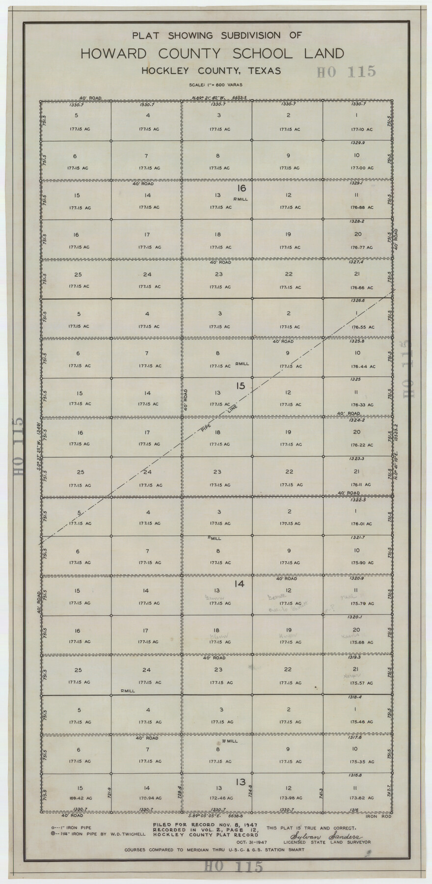
Plat Showing Subdivision of Howard County School Land Hockley County, Texas
HO115
-
Map/Doc
92256
-
Collection
Twichell Survey Records
-
Object Dates
10/31/1947 (Creation Date)
-
People and Organizations
Sylvan Sanders (Surveyor/Engineer)
-
Counties
Hockley
-
Height x Width
13.9 x 28.1 inches
35.3 x 71.4 cm
Part of: Twichell Survey Records
[S. Abercrom and surrounding surveys]
![91016, [S. Abercrom and surrounding surveys], Twichell Survey Records](https://historictexasmaps.com/wmedia_w700/maps/91016-1.tif.jpg)
Print $20.00
- Digital $50.00
[S. Abercrom and surrounding surveys]
Size 27.7 x 21.7 inches
Map/Doc 91016
[Area around J. E. Arnold survey]
![91885, [Area around J. E. Arnold survey], Twichell Survey Records](https://historictexasmaps.com/wmedia_w700/maps/91885-1.tif.jpg)
Print $2.00
- Digital $50.00
[Area around J. E. Arnold survey]
Size 15.3 x 8.2 inches
Map/Doc 91885
[S. M. Walker, D. P. Allen, J. C. Guinn, J. R. Lamar and surrounding surveys]
![90334, [S. M. Walker, D. P. Allen, J. C. Guinn, J. R. Lamar and surrounding surveys], Twichell Survey Records](https://historictexasmaps.com/wmedia_w700/maps/90334-1.tif.jpg)
Print $3.00
- Digital $50.00
[S. M. Walker, D. P. Allen, J. C. Guinn, J. R. Lamar and surrounding surveys]
1912
Size 9.7 x 11.2 inches
Map/Doc 90334
[In Northwest 1/4 of County in the vicinity of the John Walker Survey]
![90903, [In Northwest 1/4 of County in the vicinity of the John Walker Survey], Twichell Survey Records](https://historictexasmaps.com/wmedia_w700/maps/90903-1.tif.jpg)
Print $2.00
- Digital $50.00
[In Northwest 1/4 of County in the vicinity of the John Walker Survey]
Size 7.3 x 15.3 inches
Map/Doc 90903
[I. & G. N. Block 1 and surroundings]
![91539, [I. & G. N. Block 1 and surroundings], Twichell Survey Records](https://historictexasmaps.com/wmedia_w700/maps/91539-1.tif.jpg)
Print $3.00
- Digital $50.00
[I. & G. N. Block 1 and surroundings]
1892
Size 11.9 x 17.2 inches
Map/Doc 91539
[Sketch showing Block H, Section 11 of Roberts County, including the south bank of the Canadian River]
![91761, [Sketch showing Block H, Section 11 of Roberts County, including the south bank of the Canadian River], Twichell Survey Records](https://historictexasmaps.com/wmedia_w700/maps/91761-1.tif.jpg)
Print $2.00
- Digital $50.00
[Sketch showing Block H, Section 11 of Roberts County, including the south bank of the Canadian River]
1919
Size 14.4 x 8.8 inches
Map/Doc 91761
[Sections 2-5, H. & G. N. Block 12]
![91583, [Sections 2-5, H. & G. N. Block 12], Twichell Survey Records](https://historictexasmaps.com/wmedia_w700/maps/91583-1.tif.jpg)
Print $2.00
- Digital $50.00
[Sections 2-5, H. & G. N. Block 12]
Size 12.3 x 9.2 inches
Map/Doc 91583
[Southern Part of County]
![91905, [Southern Part of County], Twichell Survey Records](https://historictexasmaps.com/wmedia_w700/maps/91905-1.tif.jpg)
Print $2.00
- Digital $50.00
[Southern Part of County]
Size 9.8 x 7.6 inches
Map/Doc 91905
[Southwest part of B. S. & F. Block and surveys to the south]
![90389, [Southwest part of B. S. & F. Block and surveys to the south], Twichell Survey Records](https://historictexasmaps.com/wmedia_w700/maps/90389-1.tif.jpg)
Print $3.00
- Digital $50.00
[Southwest part of B. S. & F. Block and surveys to the south]
Size 11.1 x 10.3 inches
Map/Doc 90389
[Capitol Leagues in Lamb County]
![91014, [Capitol Leagues in Lamb County], Twichell Survey Records](https://historictexasmaps.com/wmedia_w700/maps/91014-1.tif.jpg)
Print $2.00
- Digital $50.00
[Capitol Leagues in Lamb County]
1912
Size 12.7 x 8.8 inches
Map/Doc 91014
C. B. Livestock Co.'s West-Ranch, Bailey County, Texas

Print $2.00
- Digital $50.00
C. B. Livestock Co.'s West-Ranch, Bailey County, Texas
Size 8.8 x 11.6 inches
Map/Doc 90383
[G. C. & S. 35, Part of H. & T. C. 49, Capitol Leagues 217, 218, 223, 224, 225]
![90687, [G. C. & S. 35, Part of H. & T. C. 49, Capitol Leagues 217, 218, 223, 224, 225], Twichell Survey Records](https://historictexasmaps.com/wmedia_w700/maps/90687-1.tif.jpg)
Print $3.00
- Digital $50.00
[G. C. & S. 35, Part of H. & T. C. 49, Capitol Leagues 217, 218, 223, 224, 225]
1903
Size 12.4 x 11.0 inches
Map/Doc 90687
You may also like
Gaines County Rolled Sketch 15C

Print $20.00
- Digital $50.00
Gaines County Rolled Sketch 15C
Size 33.6 x 22.7 inches
Map/Doc 75929
Hemphill County Working Sketch 33

Print $20.00
- Digital $50.00
Hemphill County Working Sketch 33
1976
Size 39.6 x 32.3 inches
Map/Doc 66128
[Beaumont, Sour Lake and Western Ry. Right of Way and Alignment - Frisco]
![64115, [Beaumont, Sour Lake and Western Ry. Right of Way and Alignment - Frisco], General Map Collection](https://historictexasmaps.com/wmedia_w700/maps/64115.tif.jpg)
Print $20.00
- Digital $50.00
[Beaumont, Sour Lake and Western Ry. Right of Way and Alignment - Frisco]
1910
Size 20.1 x 45.9 inches
Map/Doc 64115
Flight Mission No. CLL-3N, Frame 34, Willacy County

Print $20.00
- Digital $50.00
Flight Mission No. CLL-3N, Frame 34, Willacy County
1954
Size 18.6 x 22.2 inches
Map/Doc 87092
[I. Killough and Hiram Cates surveys and vicinity]
![91845, [I. Killough and Hiram Cates surveys and vicinity], Twichell Survey Records](https://historictexasmaps.com/wmedia_w700/maps/91845-1.tif.jpg)
Print $3.00
- Digital $50.00
[I. Killough and Hiram Cates surveys and vicinity]
Size 16.9 x 10.5 inches
Map/Doc 91845
Stephens County Sketch File 10b

Print $8.00
- Digital $50.00
Stephens County Sketch File 10b
1890
Size 8.5 x 7.8 inches
Map/Doc 37048
Gonzales County Working Sketch 3

Print $20.00
- Digital $50.00
Gonzales County Working Sketch 3
1943
Size 37.8 x 41.5 inches
Map/Doc 63218
Map of Atascosa County, Texas

Print $20.00
- Digital $50.00
Map of Atascosa County, Texas
1879
Size 23.7 x 29.0 inches
Map/Doc 688
Brooks County Boundary File Index

Print $2.00
- Digital $50.00
Brooks County Boundary File Index
Size 8.6 x 3.1 inches
Map/Doc 50808
Blanco County Sketch File 18

Print $4.00
- Digital $50.00
Blanco County Sketch File 18
1877
Size 12.6 x 8.5 inches
Map/Doc 14594
San Jacinto River and Tributaries, Texas - Survey of 1939

Print $20.00
- Digital $50.00
San Jacinto River and Tributaries, Texas - Survey of 1939
1939
Size 28.0 x 40.3 inches
Map/Doc 60305
Winkler County

Print $20.00
- Digital $50.00
Winkler County
1901
Size 44.1 x 37.9 inches
Map/Doc 63131