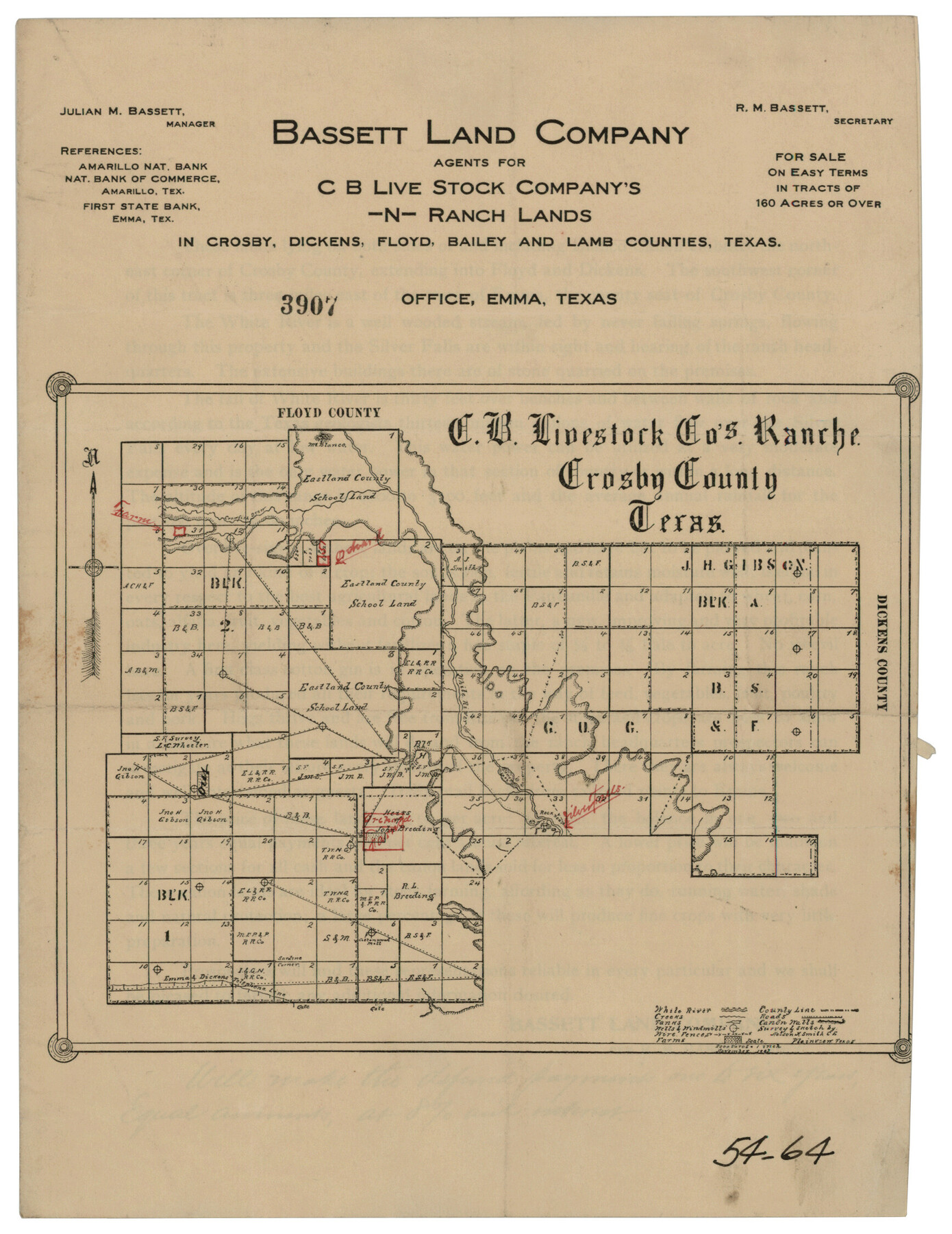
C. B. Livestock Co.'s West-Ranch, Bailey County, Texas
54-64
-
Map/Doc
90383
-
Collection
Twichell Survey Records
-
People and Organizations
Bassett Land Company (Publisher)
-
Counties
Crosby
-
Height x Width
8.8 x 11.6 inches
22.4 x 29.5 cm
-
Comments
see counter 90381 for reverse
Part of: Twichell Survey Records
Texas Boundary Line

Print $20.00
- Digital $50.00
Texas Boundary Line
Size 21.3 x 12.0 inches
Map/Doc 92079
Dr. S. C. Arnett Farm Part Section 5, Block E2

Print $20.00
- Digital $50.00
Dr. S. C. Arnett Farm Part Section 5, Block E2
Size 12.7 x 15.8 inches
Map/Doc 92296
[Sections 58-70, I. & G. N. Block 1, Runnels County School Land and part of Block 194]
![91632, [Sections 58-70, I. & G. N. Block 1, Runnels County School Land and part of Block 194], Twichell Survey Records](https://historictexasmaps.com/wmedia_w700/maps/91632-1.tif.jpg)
Print $20.00
- Digital $50.00
[Sections 58-70, I. & G. N. Block 1, Runnels County School Land and part of Block 194]
Size 23.9 x 20.9 inches
Map/Doc 91632
Map of C. W. Post's Land in Hockley County, Texas

Print $20.00
- Digital $50.00
Map of C. W. Post's Land in Hockley County, Texas
Size 24.7 x 15.7 inches
Map/Doc 91095
[E. L. & R. R. RR. Co. Blocks 9 and 10 and surveys to the east]
![90857, [E. L. & R. R. RR. Co. Blocks 9 and 10 and surveys to the east], Twichell Survey Records](https://historictexasmaps.com/wmedia_w700/maps/90857-2.tif.jpg)
Print $20.00
- Digital $50.00
[E. L. & R. R. RR. Co. Blocks 9 and 10 and surveys to the east]
1903
Size 13.4 x 19.0 inches
Map/Doc 90857
[Section 11, Block JS, Section 14, Block A, Lubbock County]
![92711, [Section 11, Block JS, Section 14, Block A, Lubbock County], Twichell Survey Records](https://historictexasmaps.com/wmedia_w700/maps/92711-1.tif.jpg)
Print $2.00
- Digital $50.00
[Section 11, Block JS, Section 14, Block A, Lubbock County]
1947
Size 7.1 x 8.5 inches
Map/Doc 92711
[T. & P. Block 35, Townships 1N - 5N]
![93138, [T. & P. Block 35, Townships 1N - 5N], Twichell Survey Records](https://historictexasmaps.com/wmedia_w700/maps/93138-1.tif.jpg)
Print $40.00
- Digital $50.00
[T. & P. Block 35, Townships 1N - 5N]
Size 23.8 x 87.2 inches
Map/Doc 93138
[Sketch showing details along East line of Lipscomb County]
![89968, [Sketch showing details along East line of Lipscomb County], Twichell Survey Records](https://historictexasmaps.com/wmedia_w700/maps/89968-1.tif.jpg)
Print $40.00
- Digital $50.00
[Sketch showing details along East line of Lipscomb County]
Size 9.9 x 66.3 inches
Map/Doc 89968
Ownership Map NE 1/4 Lubbock County [and attached letter]
![93025, Ownership Map NE 1/4 Lubbock County [and attached letter], Twichell Survey Records](https://historictexasmaps.com/wmedia_w700/maps/93025-1.tif.jpg)
Print $20.00
- Digital $50.00
Ownership Map NE 1/4 Lubbock County [and attached letter]
Size 36.3 x 39.3 inches
Map/Doc 93025
Puckett Suburban Homes in Section 4, Block O

Print $20.00
- Digital $50.00
Puckett Suburban Homes in Section 4, Block O
Size 26.2 x 13.3 inches
Map/Doc 92771
[SE/4 of NW/4 of King Co.]
![89925, [SE/4 of NW/4 of King Co.], Twichell Survey Records](https://historictexasmaps.com/wmedia_w700/maps/89925-1.tif.jpg)
Print $40.00
- Digital $50.00
[SE/4 of NW/4 of King Co.]
Size 43.7 x 55.5 inches
Map/Doc 89925
[North part of G. C. & S. F. Block OP, Runnels County School Land and Blks. AB, CD and GH]
![90310, [North part of G. C. & S. F. Block OP, Runnels County School Land and Blks. AB, CD and GH], Twichell Survey Records](https://historictexasmaps.com/wmedia_w700/maps/90310-1.tif.jpg)
Print $20.00
- Digital $50.00
[North part of G. C. & S. F. Block OP, Runnels County School Land and Blks. AB, CD and GH]
Size 17.5 x 22.4 inches
Map/Doc 90310
You may also like
Map of Crockett County

Print $40.00
- Digital $50.00
Map of Crockett County
1878
Size 62.6 x 49.7 inches
Map/Doc 93373
San Saba County Rolled Sketch 2
Print $20.00
- Digital $50.00
San Saba County Rolled Sketch 2
Size 38.9 x 20.7 inches
Map/Doc 7743
Terrell County Working Sketch 17

Print $20.00
- Digital $50.00
Terrell County Working Sketch 17
1928
Size 15.2 x 32.3 inches
Map/Doc 62166
Brewster County Rolled Sketch 121A

Print $40.00
- Digital $50.00
Brewster County Rolled Sketch 121A
1946
Size 37.4 x 54.5 inches
Map/Doc 8518
Val Verde County Sketch File 29

Print $20.00
- Digital $50.00
Val Verde County Sketch File 29
Size 33.1 x 23.8 inches
Map/Doc 76760
Harris County Working Sketch 116

Print $20.00
- Digital $50.00
Harris County Working Sketch 116
1983
Size 24.2 x 23.3 inches
Map/Doc 66008
Morris County Sketch File 4

Print $4.00
- Digital $50.00
Morris County Sketch File 4
1910
Size 8.3 x 8.6 inches
Map/Doc 31968
Texas: Her Resources and Capabilities: being a description of the State of Texas and the inducements She offers to those seeking homes in a new country

Texas: Her Resources and Capabilities: being a description of the State of Texas and the inducements She offers to those seeking homes in a new country
1881
Size 9.3 x 6.1 inches
Map/Doc 96615
Pecos County Sketch File 85

Print $19.00
- Digital $50.00
Pecos County Sketch File 85
1948
Size 14.6 x 9.2 inches
Map/Doc 33955
Grayson County Working Sketch 14

Print $20.00
- Digital $50.00
Grayson County Working Sketch 14
1952
Size 23.9 x 23.3 inches
Map/Doc 63253
General Highway Map, Mason County, Texas

Print $20.00
General Highway Map, Mason County, Texas
1961
Size 18.3 x 24.8 inches
Map/Doc 79584
Sherman County Sketch File 3

Print $26.00
- Digital $50.00
Sherman County Sketch File 3
1925
Size 7.7 x 8.9 inches
Map/Doc 36675