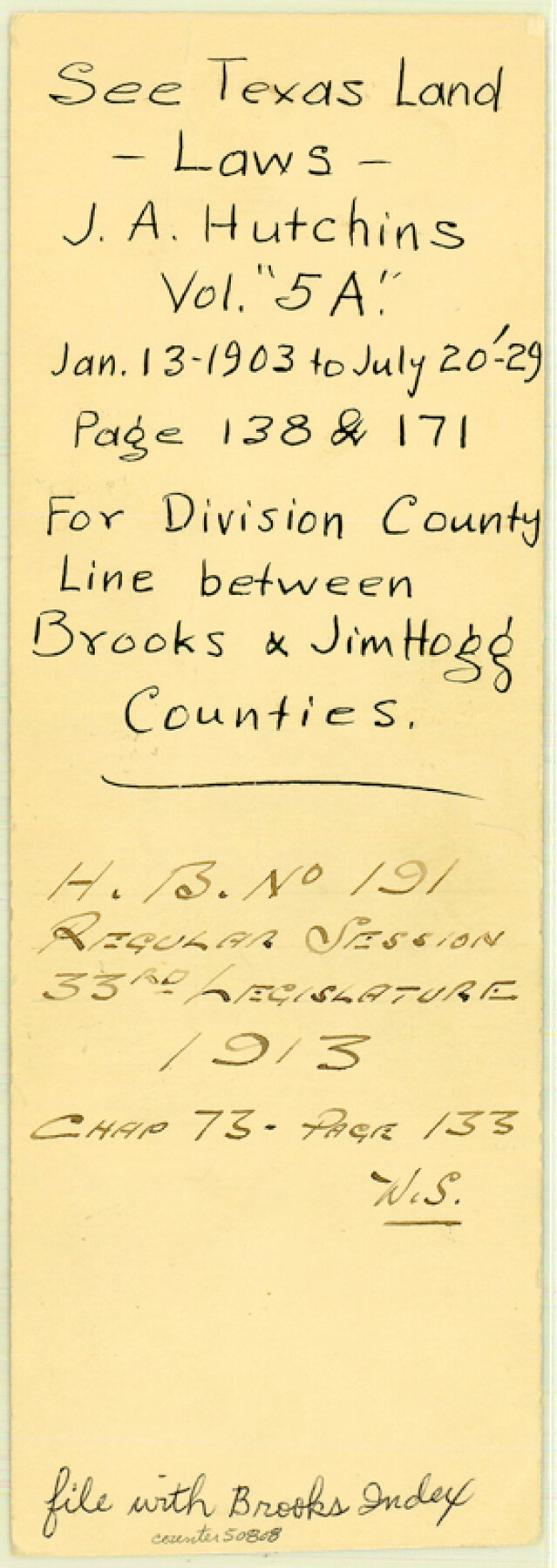
Brooks County Boundary File Index
H.B. No. 191 Regular Session 33rd Legislature 1913 Chap. 73 - Page 133
-
Map/Doc
50808
-
Collection
General Map Collection
-
Counties
Brooks
-
Subjects
County Boundaries
-
Height x Width
8.6 x 3.1 inches
21.8 x 7.9 cm
Part of: General Map Collection
San Jacinto County Sketch File 17

Print $40.00
San Jacinto County Sketch File 17
1934
Size 60.1 x 26.3 inches
Map/Doc 10598
Dickens County Rolled Sketch 8

Print $20.00
- Digital $50.00
Dickens County Rolled Sketch 8
1953
Size 42.9 x 23.7 inches
Map/Doc 5707
Atascosa County Sketch File 27b

Print $10.00
- Digital $50.00
Atascosa County Sketch File 27b
1875
Size 12.6 x 8.2 inches
Map/Doc 13801
[Location St. L. & S. W. R. R. Through Cherokee County]
![64045, [Location St. L. & S. W. R. R. Through Cherokee County], General Map Collection](https://historictexasmaps.com/wmedia_w700/maps/64045-1.tif.jpg)
Print $40.00
- Digital $50.00
[Location St. L. & S. W. R. R. Through Cherokee County]
Size 38.7 x 76.6 inches
Map/Doc 64045
Bosque County Sketch File 11

Print $4.00
- Digital $50.00
Bosque County Sketch File 11
1863
Size 10.2 x 8.3 inches
Map/Doc 14759
Victoria County Sketch File 4

Print $7.00
- Digital $50.00
Victoria County Sketch File 4
1876
Size 10.1 x 8.2 inches
Map/Doc 39517
Montgomery County Working Sketch 66

Print $20.00
- Digital $50.00
Montgomery County Working Sketch 66
1967
Size 24.7 x 29.0 inches
Map/Doc 71173
Flight Mission No. CRE-1R, Frame 66, Jackson County

Print $20.00
- Digital $50.00
Flight Mission No. CRE-1R, Frame 66, Jackson County
1956
Size 16.2 x 16.1 inches
Map/Doc 85329
Fort Bend County State Real Property Sketch 9

Print $40.00
- Digital $50.00
Fort Bend County State Real Property Sketch 9
1986
Size 34.7 x 43.2 inches
Map/Doc 61683
Crockett County Rolled Sketch RC1

Print $20.00
- Digital $50.00
Crockett County Rolled Sketch RC1
1935
Size 43.7 x 30.6 inches
Map/Doc 8701
Brazoria County NRC Article 33.136 Sketch 3

Print $20.00
- Digital $50.00
Brazoria County NRC Article 33.136 Sketch 3
2002
Size 40.6 x 29.6 inches
Map/Doc 77039
A New Map of Texas

Print $20.00
- Digital $50.00
A New Map of Texas
Size 18.2 x 17.2 inches
Map/Doc 96636
You may also like
Briscoe County

Print $20.00
- Digital $50.00
Briscoe County
1930
Size 46.2 x 39.2 inches
Map/Doc 1787
America siue India Nova ad magnae Gerardi Mercatoris aui Vniversalis imitationem in compendium redacta

Print $20.00
- Digital $50.00
America siue India Nova ad magnae Gerardi Mercatoris aui Vniversalis imitationem in compendium redacta
1585
Size 16.9 x 20.2 inches
Map/Doc 93808
Leon County Working Sketch 59

Print $20.00
- Digital $50.00
Leon County Working Sketch 59
1998
Size 19.2 x 25.5 inches
Map/Doc 70459
Kimble County Working Sketch 27

Print $20.00
- Digital $50.00
Kimble County Working Sketch 27
1934
Size 16.1 x 17.3 inches
Map/Doc 70095
King County Working Sketch 11

Print $40.00
- Digital $50.00
King County Working Sketch 11
1971
Size 49.7 x 25.0 inches
Map/Doc 70175
Flight Mission No. CRE-2R, Frame 172, Jackson County

Print $20.00
- Digital $50.00
Flight Mission No. CRE-2R, Frame 172, Jackson County
1956
Size 18.5 x 22.2 inches
Map/Doc 85382
Fort Bend County Rolled Sketch 17

Print $20.00
- Digital $50.00
Fort Bend County Rolled Sketch 17
1997
Size 28.0 x 38.5 inches
Map/Doc 5901
Gonzales County Working Sketch 12

Print $20.00
- Digital $50.00
Gonzales County Working Sketch 12
1981
Size 13.1 x 11.9 inches
Map/Doc 63228
Hardin County Sketch File A

Print $20.00
- Digital $50.00
Hardin County Sketch File A
Size 19.3 x 33.4 inches
Map/Doc 11644
[Office Sketch Showing Surveys North of Loma Blanca Grant, Brooks County, Texas]
![412, [Office Sketch Showing Surveys North of Loma Blanca Grant, Brooks County, Texas], Maddox Collection](https://historictexasmaps.com/wmedia_w700/maps/0412.tif.jpg)
Print $20.00
- Digital $50.00
[Office Sketch Showing Surveys North of Loma Blanca Grant, Brooks County, Texas]
Size 16.6 x 19.6 inches
Map/Doc 412
Marion County Working Sketch 38

Print $20.00
- Digital $50.00
Marion County Working Sketch 38
1991
Size 35.5 x 39.9 inches
Map/Doc 70814
General Highway Map, Loving County, Texas

Print $20.00
General Highway Map, Loving County, Texas
1940
Size 18.3 x 24.8 inches
Map/Doc 79179