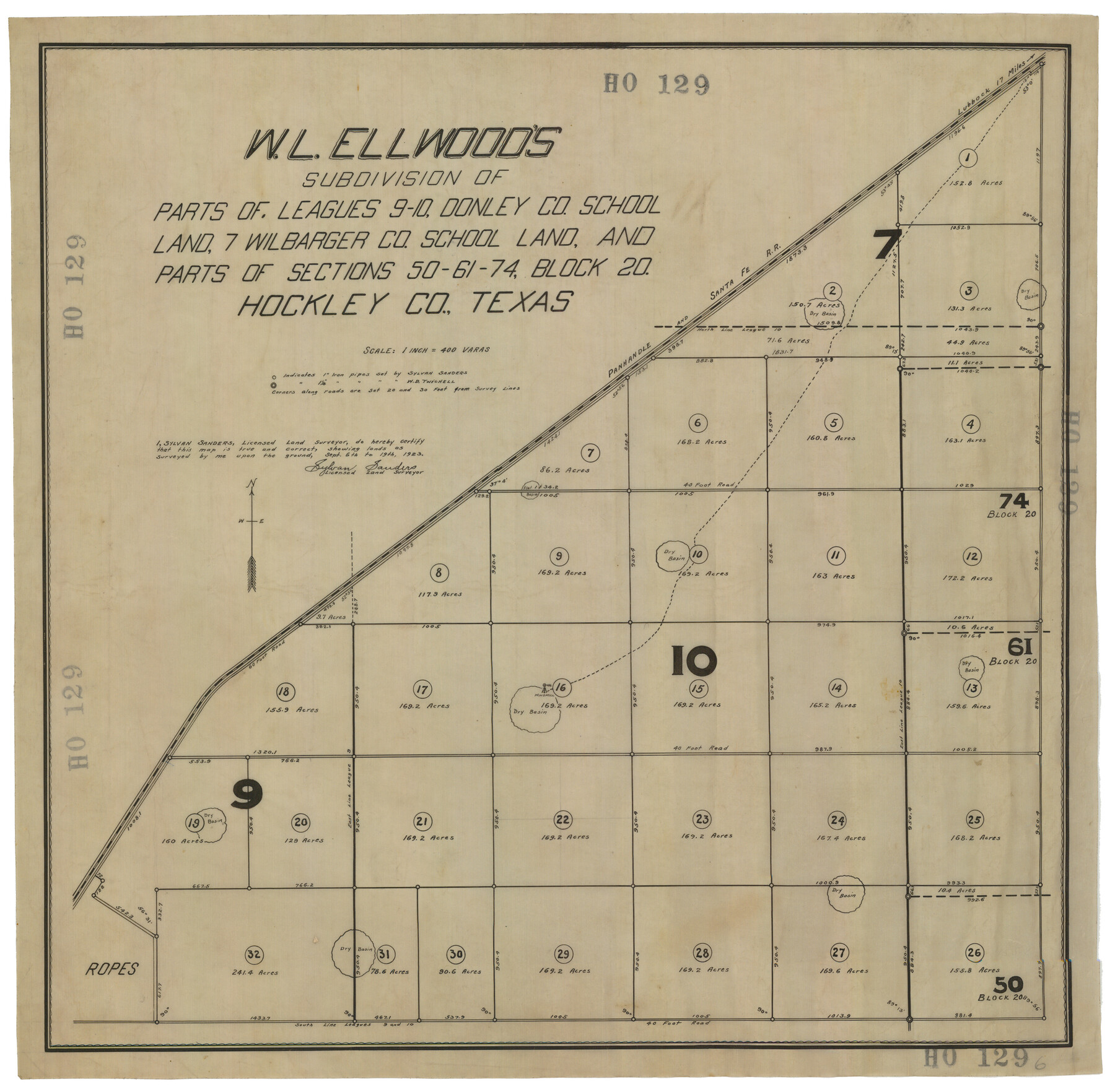
W. L. Ellwood's Subdivision of Parts of Leagues 9 and 10, Donley County School Land, 7 Wilbarger County School Land and Parts of Section 50, 61, and 74, Block 20 Hockley County, Texas
HO129
-
Map/Doc
92249
-
Collection
Twichell Survey Records
-
Object Dates
9/19/1923 (Creation Date)
-
People and Organizations
Sylvan Sanders (Surveyor/Engineer)
-
Counties
Hockley
-
Height x Width
20.2 x 19.8 inches
51.3 x 50.3 cm
Part of: Twichell Survey Records

A Portion of Yoakum County, Texas and Gaines County, Texas in the vicinity of the Wasson Oil Field

Print $20.00
- Digital $50.00
A Portion of Yoakum County, Texas and Gaines County, Texas in the vicinity of the Wasson Oil Field
Size 43.4 x 32.0 inches
Map/Doc 90808
[B. S. & F. Block 1 and A. B. & M. Block 2]
![91815, [B. S. & F. Block 1 and A. B. & M. Block 2], Twichell Survey Records](https://historictexasmaps.com/wmedia_w700/maps/91815-1.tif.jpg)
Print $20.00
- Digital $50.00
[B. S. & F. Block 1 and A. B. & M. Block 2]
Size 14.0 x 21.5 inches
Map/Doc 91815
[Blocks GG, 1, 29, A2, Archer County School Land Sections 1,2,3,4]
![92439, [Blocks GG, 1, 29, A2, Archer County School Land Sections 1,2,3,4], Twichell Survey Records](https://historictexasmaps.com/wmedia_w700/maps/92439-1.tif.jpg)
Print $20.00
- Digital $50.00
[Blocks GG, 1, 29, A2, Archer County School Land Sections 1,2,3,4]
Size 26.7 x 19.0 inches
Map/Doc 92439
Plat Compiled by W.J. Williams, Plainview, Texas, and Sylvan Sanders, Lubbock, Texas Showing Position of Original and Re-Survey Corners in Lynn, Terry, Yoakum, Gaines, and Dawson Counties, Texas

Print $40.00
- Digital $50.00
Plat Compiled by W.J. Williams, Plainview, Texas, and Sylvan Sanders, Lubbock, Texas Showing Position of Original and Re-Survey Corners in Lynn, Terry, Yoakum, Gaines, and Dawson Counties, Texas
1946
Size 56.6 x 22.6 inches
Map/Doc 89628
Section C Tech Memorial Park, Inc.

Print $2.00
- Digital $50.00
Section C Tech Memorial Park, Inc.
Size 8.1 x 10.5 inches
Map/Doc 92351
[Sketch showing Runnels County School Land survey and surrounding surveys]
![93112, [Sketch showing Runnels County School Land survey and surrounding surveys], Twichell Survey Records](https://historictexasmaps.com/wmedia_w700/maps/93112-1.tif.jpg)
Print $20.00
- Digital $50.00
[Sketch showing Runnels County School Land survey and surrounding surveys]
Size 21.4 x 14.3 inches
Map/Doc 93112
[H. & G. N. Block B3]
![89982, [H. & G. N. Block B3], Twichell Survey Records](https://historictexasmaps.com/wmedia_w700/maps/89982-1.tif.jpg)
Print $3.00
- Digital $50.00
[H. & G. N. Block B3]
Size 17.4 x 8.1 inches
Map/Doc 89982
Map Showing the Relative Positions of the Various Surveys Delineated Thereon

Print $20.00
- Digital $50.00
Map Showing the Relative Positions of the Various Surveys Delineated Thereon
Size 23.0 x 18.6 inches
Map/Doc 91500
P. W. Walker Seed and Grain Co. Littlefield, Texas

Print $20.00
- Digital $50.00
P. W. Walker Seed and Grain Co. Littlefield, Texas
1950
Size 36.9 x 15.8 inches
Map/Doc 92404

Map of a part of Block One, I. & G. N. RR. Co. and the Pecos River

Print $20.00
- Digital $50.00
Map of a part of Block One, I. & G. N. RR. Co. and the Pecos River
1927
Size 34.2 x 17.4 inches
Map/Doc 90320
You may also like
McMullen County Working Sketch 54

Print $20.00
- Digital $50.00
McMullen County Working Sketch 54
1983
Size 25.3 x 29.0 inches
Map/Doc 70755
[Township 3 North, Blocks 33 and 34, T. & P. RR. Company; Township 4 North, Block 33, T. & P. RR. Company]
![92564, [Township 3 North, Blocks 33 and 34, T. & P. RR. Company; Township 4 North, Block 33, T. & P. RR. Company], Twichell Survey Records](https://historictexasmaps.com/wmedia_w700/maps/92564-1.tif.jpg)
Print $20.00
- Digital $50.00
[Township 3 North, Blocks 33 and 34, T. & P. RR. Company; Township 4 North, Block 33, T. & P. RR. Company]
1911
Size 18.6 x 24.8 inches
Map/Doc 92564
Waco, Tex., County Seat of McLennan Co.

Print $20.00
Waco, Tex., County Seat of McLennan Co.
1886
Size 23.1 x 32.7 inches
Map/Doc 89212
King County Sketch File 7

Print $72.00
- Digital $50.00
King County Sketch File 7
1901
Size 11.1 x 8.5 inches
Map/Doc 29030
Fort Bend County Sketch File 29

Print $20.00
- Digital $50.00
Fort Bend County Sketch File 29
1912
Size 18.3 x 26.1 inches
Map/Doc 11512
Mitchell County

Print $20.00
- Digital $50.00
Mitchell County
1971
Size 43.6 x 37.0 inches
Map/Doc 95592
Terrell County

Print $40.00
- Digital $50.00
Terrell County
1931
Size 48.5 x 40.5 inches
Map/Doc 73300
Mills County Rolled Sketch 3

Print $20.00
- Digital $50.00
Mills County Rolled Sketch 3
1998
Size 26.4 x 37.9 inches
Map/Doc 6781
Van Zandt County Working Sketch 14

Print $20.00
- Digital $50.00
Van Zandt County Working Sketch 14
1982
Size 13.2 x 11.5 inches
Map/Doc 72264
Aransas County Rolled Sketch 16

Digital $50.00
Aransas County Rolled Sketch 16
Size 44.1 x 92.5 inches
Map/Doc 8412
Val Verde County Working Sketch 2

Print $20.00
- Digital $50.00
Val Verde County Working Sketch 2
Size 27.9 x 23.8 inches
Map/Doc 72137
Flight Mission No. DIX-6P, Frame 132, Aransas County

Print $20.00
- Digital $50.00
Flight Mission No. DIX-6P, Frame 132, Aransas County
1956
Size 19.3 x 23.2 inches
Map/Doc 83838