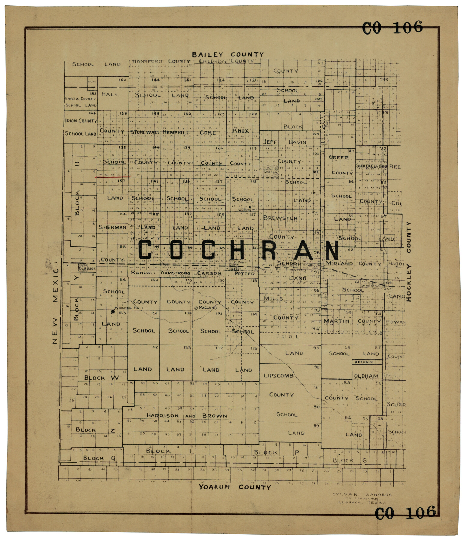
Cochran County
CO106
-
Map/Doc
92494
-
Collection
Twichell Survey Records
-
People and Organizations
Sylvan Sanders (Surveyor/Engineer)
-
Counties
Cochran
-
Subjects
County
-
Height x Width
14.8 x 17.2 inches
37.6 x 43.7 cm
Part of: Twichell Survey Records
[Map showing Jno. H. Gibson Block D]
![92001, [Map showing Jno. H. Gibson Block D], Twichell Survey Records](https://historictexasmaps.com/wmedia_w700/maps/92001-1.tif.jpg)
Print $20.00
- Digital $50.00
[Map showing Jno. H. Gibson Block D]
Size 17.9 x 15.0 inches
Map/Doc 92001
N. C. Payne Land in Lamb and Hale Counties]
![91060, N. C. Payne Land in Lamb and Hale Counties], Twichell Survey Records](https://historictexasmaps.com/wmedia_w700/maps/91060-1.tif.jpg)
Print $20.00
- Digital $50.00
N. C. Payne Land in Lamb and Hale Counties]
Size 18.6 x 23.9 inches
Map/Doc 91060
[Block XR, Capitol Leagues 161, 162, 164, 174, 178, 179, and 180]
![90729, [Block XR, Capitol Leagues 161, 162, 164, 174, 178, 179, and 180], Twichell Survey Records](https://historictexasmaps.com/wmedia_w700/maps/90729-1.tif.jpg)
Print $20.00
- Digital $50.00
[Block XR, Capitol Leagues 161, 162, 164, 174, 178, 179, and 180]
1908
Size 13.1 x 21.6 inches
Map/Doc 90729
Property Line Map, Public Housing Authority

Print $3.00
- Digital $50.00
Property Line Map, Public Housing Authority
Size 11.9 x 15.5 inches
Map/Doc 92707
[Oil and Gas Fields in West Texas]
![89884, [Oil and Gas Fields in West Texas], Twichell Survey Records](https://historictexasmaps.com/wmedia_w700/maps/89884-1.tif.jpg)
Print $40.00
- Digital $50.00
[Oil and Gas Fields in West Texas]
Size 38.5 x 59.2 inches
Map/Doc 89884
General Highway Map, Lubbock County

Print $20.00
- Digital $50.00
General Highway Map, Lubbock County
1947
Size 25.1 x 18.9 inches
Map/Doc 92718
[Block J and vicinity]
![91239, [Block J and vicinity], Twichell Survey Records](https://historictexasmaps.com/wmedia_w700/maps/91239-1.tif.jpg)
Print $20.00
- Digital $50.00
[Block J and vicinity]
Size 19.8 x 30.5 inches
Map/Doc 91239
[Blocks DD, C33, C32, C31, C36, C37, C38, C39, C41, C40, T]
![92935, [Blocks DD, C33, C32, C31, C36, C37, C38, C39, C41, C40, T], Twichell Survey Records](https://historictexasmaps.com/wmedia_w700/maps/92935-1.tif.jpg)
Print $20.00
- Digital $50.00
[Blocks DD, C33, C32, C31, C36, C37, C38, C39, C41, C40, T]
Size 44.0 x 24.8 inches
Map/Doc 92935
[County School Land for Shackelford, Reeves, Hardeman, Val Verde, Hood, Martin, Rusk, Atascosa, and Edwards Counties]
![91114, [County School Land for Shackelford, Reeves, Hardeman, Val Verde, Hood, Martin, Rusk, Atascosa, and Edwards Counties], Twichell Survey Records](https://historictexasmaps.com/wmedia_w700/maps/91114-1.tif.jpg)
Print $2.00
- Digital $50.00
[County School Land for Shackelford, Reeves, Hardeman, Val Verde, Hood, Martin, Rusk, Atascosa, and Edwards Counties]
Size 8.2 x 5.9 inches
Map/Doc 91114
Secs. 58-69, I&GN Blk. 1

Print $20.00
- Digital $50.00
Secs. 58-69, I&GN Blk. 1
Size 27.5 x 25.3 inches
Map/Doc 91617
[Sketch Showing Wm. T. Brewer, John R. Taylor, Wm. F. Butler, Timothy DeVore, L. M. Thorn and adjoining surveys]
![89745, [Sketch Showing Wm. T. Brewer, John R. Taylor, Wm. F. Butler, Timothy DeVore, L. M. Thorn and adjoining surveys], Twichell Survey Records](https://historictexasmaps.com/wmedia_w700/maps/89745-1.tif.jpg)
Print $40.00
- Digital $50.00
[Sketch Showing Wm. T. Brewer, John R. Taylor, Wm. F. Butler, Timothy DeVore, L. M. Thorn and adjoining surveys]
Size 37.1 x 56.1 inches
Map/Doc 89745
Revised Plat of Tahoka Heights Addition Located on the SE 1/4 of Section 568

Print $20.00
- Digital $50.00
Revised Plat of Tahoka Heights Addition Located on the SE 1/4 of Section 568
Size 17.5 x 21.9 inches
Map/Doc 92942
You may also like
Starr County Sketch File 40

Print $4.00
- Digital $50.00
Starr County Sketch File 40
1940
Size 14.2 x 8.8 inches
Map/Doc 36989
Clay County Sketch File 38

Print $4.00
- Digital $50.00
Clay County Sketch File 38
Size 16.4 x 25.0 inches
Map/Doc 11092
Hardin County Sketch File 49

Print $4.00
- Digital $50.00
Hardin County Sketch File 49
1904
Size 14.5 x 8.8 inches
Map/Doc 25202
Uvalde County

Print $20.00
- Digital $50.00
Uvalde County
1915
Size 42.9 x 46.2 inches
Map/Doc 63091
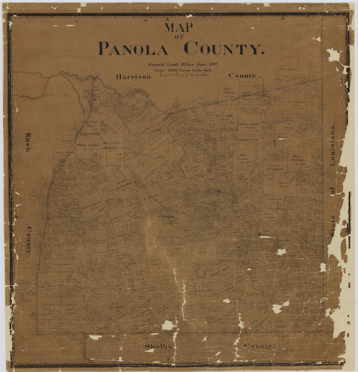
Map of Panola County
Print $20.00
- Digital $50.00
Map of Panola County
1897
Size 40.5 x 39.0 inches
Map/Doc 16785
The Republic County of Harrison. June 24, 1841

Print $20.00
The Republic County of Harrison. June 24, 1841
2020
Size 18.6 x 21.7 inches
Map/Doc 96171
Nueces County Sketch File 10

Print $4.00
- Digital $50.00
Nueces County Sketch File 10
Size 8.2 x 10.1 inches
Map/Doc 32516
Red River County Working Sketch 14

Print $20.00
- Digital $50.00
Red River County Working Sketch 14
1952
Size 37.8 x 22.9 inches
Map/Doc 71997
Hudspeth County Rolled Sketch 54

Print $177.00
- Digital $50.00
Hudspeth County Rolled Sketch 54
1977
Size 10.2 x 15.0 inches
Map/Doc 45887
Orange County Working Sketch 15

Print $20.00
- Digital $50.00
Orange County Working Sketch 15
1928
Size 19.3 x 24.6 inches
Map/Doc 71347
Presidio County Rolled Sketch 129

Print $20.00
- Digital $50.00
Presidio County Rolled Sketch 129
1989
Size 27.0 x 46.0 inches
Map/Doc 7399
McLennan County Boundary File 3a

Print $30.00
- Digital $50.00
McLennan County Boundary File 3a
Size 14.1 x 8.5 inches
Map/Doc 56967