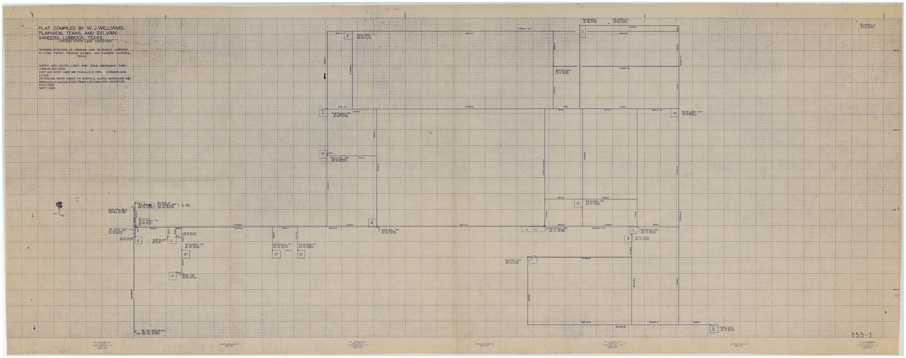
Plat Compiled by W.J. Williams, Plainview, Texas, and Sylvan Sanders, Lubbock, Texas Showing Position of Original and Re-Survey Corners in Lynn, Terry, Yoakum, Gaines, and Dawson Counties, Texas
153-1
Part of: Twichell Survey Records
[Area along North line of McLennan County School Land]
![90928, [Area along North line of McLennan County School Land], Twichell Survey Records](https://historictexasmaps.com/wmedia_w700/maps/90928-1.tif.jpg)
Print $2.00
- Digital $50.00
[Area along North line of McLennan County School Land]
1920
Size 5.5 x 14.9 inches
Map/Doc 90928
[West line of H. & T. C. RR. Block 97 and Blocks 29 and 30]
![90212, [West line of H. & T. C. RR. Block 97 and Blocks 29 and 30], Twichell Survey Records](https://historictexasmaps.com/wmedia_w700/maps/90212-1.tif.jpg)
Print $20.00
- Digital $50.00
[West line of H. & T. C. RR. Block 97 and Blocks 29 and 30]
Size 17.2 x 25.3 inches
Map/Doc 90212
Part of South Half of Section 4, Block O

Print $20.00
- Digital $50.00
Part of South Half of Section 4, Block O
1953
Size 21.1 x 17.2 inches
Map/Doc 92780
[Capitol Leagues 633- 664]
![91076, [Capitol Leagues 633- 664], Twichell Survey Records](https://historictexasmaps.com/wmedia_w700/maps/91076-1.tif.jpg)
Print $20.00
- Digital $50.00
[Capitol Leagues 633- 664]
Size 17.0 x 14.6 inches
Map/Doc 91076
[Block V and surrounding surveys]
![90292, [Block V and surrounding surveys], Twichell Survey Records](https://historictexasmaps.com/wmedia_w700/maps/90292-1.tif.jpg)
Print $3.00
- Digital $50.00
[Block V and surrounding surveys]
Size 11.9 x 12.5 inches
Map/Doc 90292
[League 27, Montgomery County School Land, William Tubbs Survey]
![91127, [League 27, Montgomery County School Land, William Tubbs Survey], Twichell Survey Records](https://historictexasmaps.com/wmedia_w700/maps/91127-1.tif.jpg)
Print $2.00
- Digital $50.00
[League 27, Montgomery County School Land, William Tubbs Survey]
Size 11.7 x 8.9 inches
Map/Doc 91127
[8 Ranch, Kent County, Texas]
![91032, [8 Ranch, Kent County, Texas], Twichell Survey Records](https://historictexasmaps.com/wmedia_w700/maps/91032-1.tif.jpg)
Print $20.00
- Digital $50.00
[8 Ranch, Kent County, Texas]
1946
Size 21.4 x 37.4 inches
Map/Doc 91032
Caldwell County

Print $20.00
- Digital $50.00
Caldwell County
1896
Size 42.7 x 33.3 inches
Map/Doc 93039

[Sketch of most of Crosby County]
![89762, [Sketch of most of Crosby County], Twichell Survey Records](https://historictexasmaps.com/wmedia_w700/maps/89762-1.tif.jpg)
Print $40.00
- Digital $50.00
[Sketch of most of Crosby County]
Size 54.9 x 45.3 inches
Map/Doc 89762
[Resurvey of the north half of Block M6]
![90400, [Resurvey of the north half of Block M6], Twichell Survey Records](https://historictexasmaps.com/wmedia_w700/maps/90400-1.tif.jpg)
Print $20.00
- Digital $50.00
[Resurvey of the north half of Block M6]
Size 19.0 x 21.1 inches
Map/Doc 90400
[Plat showing connecting lines for the purpose of locating 4.3 acres in Caldwell County]
![90220, [Plat showing connecting lines for the purpose of locating 4.3 acres in Caldwell County], Twichell Survey Records](https://historictexasmaps.com/wmedia_w700/maps/90220-1.tif.jpg)
Print $2.00
- Digital $50.00
[Plat showing connecting lines for the purpose of locating 4.3 acres in Caldwell County]
1923
Size 7.4 x 10.2 inches
Map/Doc 90220
You may also like
Travis County Rolled Sketch 47

Print $40.00
- Digital $50.00
Travis County Rolled Sketch 47
1925
Size 24.9 x 56.8 inches
Map/Doc 10016
Frio County Rolled Sketch 28

Print $20.00
- Digital $50.00
Frio County Rolled Sketch 28
2014
Size 36.3 x 24.7 inches
Map/Doc 97420
Railroad map of the state of Texas / compiled and engraved expressly for the American railroad manual.

Print $20.00
Railroad map of the state of Texas / compiled and engraved expressly for the American railroad manual.
1873
Size 13.4 x 9.5 inches
Map/Doc 93599
Flight Mission No. DIX-8P, Frame 89, Aransas County

Print $20.00
- Digital $50.00
Flight Mission No. DIX-8P, Frame 89, Aransas County
1956
Size 18.7 x 22.4 inches
Map/Doc 83914
Ward County Rolled Sketch 18

Print $20.00
- Digital $50.00
Ward County Rolled Sketch 18
1949
Size 31.6 x 34.0 inches
Map/Doc 10109
Orange County Working Sketch 25

Print $20.00
- Digital $50.00
Orange County Working Sketch 25
1949
Size 30.7 x 32.6 inches
Map/Doc 71357
Comal County Boundary File 1

Print $5.00
- Digital $50.00
Comal County Boundary File 1
Size 12.9 x 11.0 inches
Map/Doc 51776
[Sketch for Mineral Application 24072, San Jacinto River]
![65605, [Sketch for Mineral Application 24072, San Jacinto River], General Map Collection](https://historictexasmaps.com/wmedia_w700/maps/65605.tif.jpg)
Print $20.00
- Digital $50.00
[Sketch for Mineral Application 24072, San Jacinto River]
1929
Size 23.4 x 17.8 inches
Map/Doc 65605
Reagan County Sketch File 8

Print $20.00
- Digital $50.00
Reagan County Sketch File 8
Size 25.6 x 47.6 inches
Map/Doc 10584
Cherokee County Sketch File 10

Print $4.00
- Digital $50.00
Cherokee County Sketch File 10
1847
Size 8.2 x 9.5 inches
Map/Doc 18136
Edwards County Sketch File A

Print $20.00
- Digital $50.00
Edwards County Sketch File A
Size 25.3 x 35.5 inches
Map/Doc 11448
Tarrant County

Print $20.00
- Digital $50.00
Tarrant County
1873
Size 19.1 x 17.5 inches
Map/Doc 4065