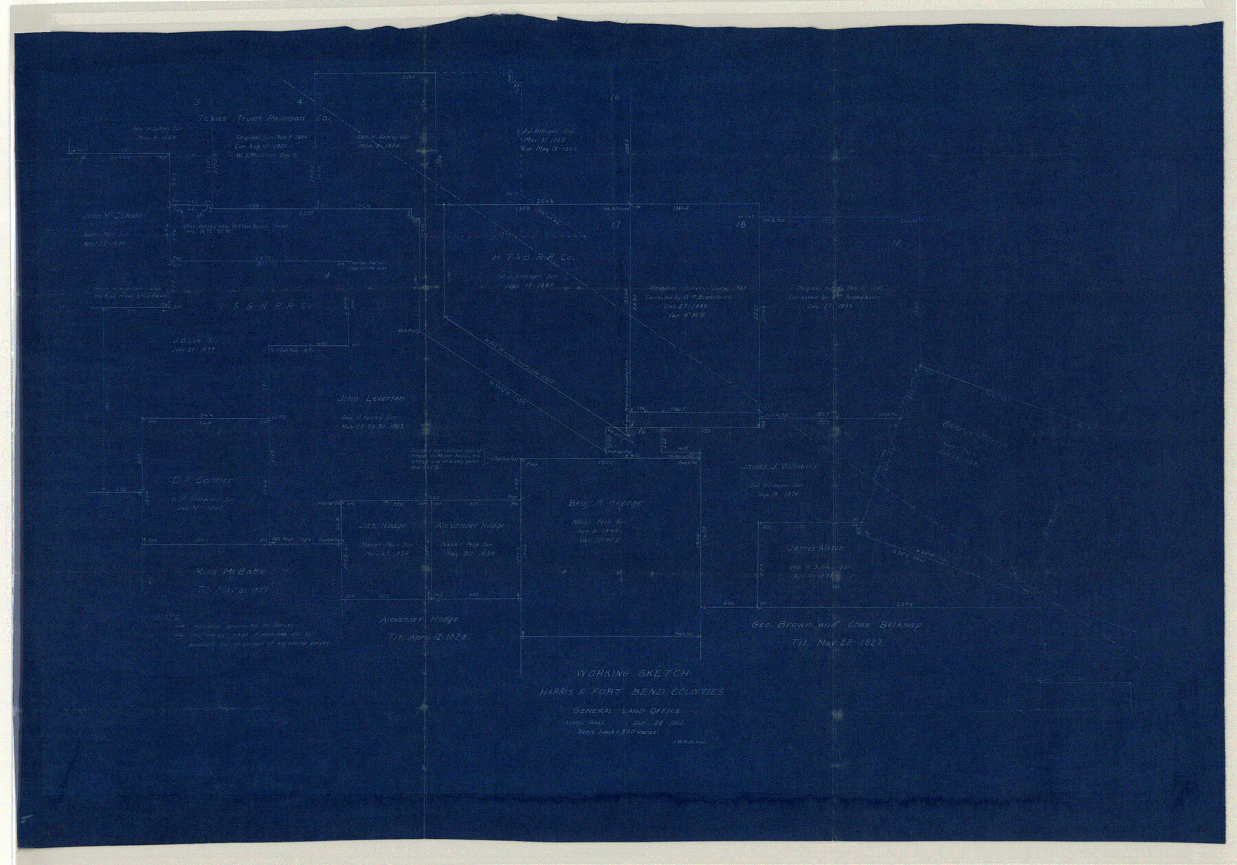
Fort Bend County Sketch File 29
Harris & Fort Bend Cos.
-
Map/Doc
11512
-
Collection
General Map Collection
-
Object Dates
1912/10/29 (Creation Date)
1912/10/29 (File Date)
1912/10/28 (Creation Date)
-
People and Organizations
Pritchett (Surveyor/Engineer)
-
Counties
Fort Bend Harris
-
Subjects
Surveying Sketch File
-
Height x Width
18.3 x 26.1 inches
46.5 x 66.3 cm
-
Medium
blueprint/diazo
-
Scale
1:500
Part of: General Map Collection

Bee County Sketch File X

Print $6.00
- Digital $50.00
Bee County Sketch File X
Size 11.5 x 11.0 inches
Map/Doc 14243
Hunt County Sketch File 39

Print $8.00
- Digital $50.00
Hunt County Sketch File 39
1922
Size 14.3 x 8.8 inches
Map/Doc 27159
Travis County Rolled Sketch 28

Print $20.00
- Digital $50.00
Travis County Rolled Sketch 28
1941
Size 22.7 x 27.0 inches
Map/Doc 8030
Flight Mission No. DQO-6K, Frame 20, Galveston County

Print $20.00
- Digital $50.00
Flight Mission No. DQO-6K, Frame 20, Galveston County
1952
Size 18.8 x 22.3 inches
Map/Doc 85093
Bastrop County Working Sketch Graphic Index

Print $40.00
- Digital $50.00
Bastrop County Working Sketch Graphic Index
1955
Size 49.6 x 40.9 inches
Map/Doc 76462
Sabine River, East Extension Merrill Lake Sheet

Print $4.00
- Digital $50.00
Sabine River, East Extension Merrill Lake Sheet
1933
Size 24.5 x 15.1 inches
Map/Doc 65141
Fannin County Boundary File 1

Print $14.00
- Digital $50.00
Fannin County Boundary File 1
Size 13.2 x 8.6 inches
Map/Doc 53272
Travis County Appraisal District Plat Map 2_0801

Print $20.00
- Digital $50.00
Travis County Appraisal District Plat Map 2_0801
Size 21.4 x 26.4 inches
Map/Doc 94237
Foard County Sketch File 35

Print $20.00
- Digital $50.00
Foard County Sketch File 35
Size 25.2 x 24.8 inches
Map/Doc 6067
Flight Mission No. DAG-21K, Frame 123, Matagorda County

Print $20.00
- Digital $50.00
Flight Mission No. DAG-21K, Frame 123, Matagorda County
1952
Size 18.5 x 22.4 inches
Map/Doc 86449
Mills County Rolled Sketch 4

Print $20.00
- Digital $50.00
Mills County Rolled Sketch 4
2000
Size 26.6 x 21.6 inches
Map/Doc 6782
You may also like
Menard County Working Sketch 9

Print $20.00
- Digital $50.00
Menard County Working Sketch 9
1937
Size 22.9 x 22.5 inches
Map/Doc 70956
Crockett County Rolled Sketch 73

Print $20.00
- Digital $50.00
Crockett County Rolled Sketch 73
1949
Size 10.4 x 23.6 inches
Map/Doc 5614
Atascosa County Rolled Sketch 5B2

Print $20.00
- Digital $50.00
Atascosa County Rolled Sketch 5B2
1910
Size 16.4 x 12.5 inches
Map/Doc 5091
Nueces County Sketch File 56

Print $113.00
- Digital $50.00
Nueces County Sketch File 56
1973
Size 10.1 x 9.3 inches
Map/Doc 32874
Waller County Working Sketch 3

Print $20.00
- Digital $50.00
Waller County Working Sketch 3
1959
Size 35.4 x 28.8 inches
Map/Doc 72302
Fisher County Working Sketch 15

Print $20.00
- Digital $50.00
Fisher County Working Sketch 15
1958
Size 22.2 x 22.6 inches
Map/Doc 69149
[Missouri, Kansas & Texas Line Map through Bastrop County]
![64033, [Missouri, Kansas & Texas Line Map through Bastrop County], General Map Collection](https://historictexasmaps.com/wmedia_w700/maps/64033.tif.jpg)
Print $40.00
- Digital $50.00
[Missouri, Kansas & Texas Line Map through Bastrop County]
1916
Size 25.2 x 68.9 inches
Map/Doc 64033
Marion County Working Sketch 32

Print $40.00
- Digital $50.00
Marion County Working Sketch 32
1982
Size 50.0 x 43.3 inches
Map/Doc 70808
Carta Orografica

Print $20.00
- Digital $50.00
Carta Orografica
Size 26.0 x 34.4 inches
Map/Doc 96802
Childress County

Print $20.00
- Digital $50.00
Childress County
1921
Size 43.8 x 32.6 inches
Map/Doc 66753
Map of the Paluxy Artesian Reservoirs of the Black and Grand Prairies of Texas including the Eastern and Western Cross Timbers

Print $20.00
- Digital $50.00
Map of the Paluxy Artesian Reservoirs of the Black and Grand Prairies of Texas including the Eastern and Western Cross Timbers
1900
Size 24.8 x 24.4 inches
Map/Doc 75919
Presidio County Rolled Sketch 48

Print $20.00
- Digital $50.00
Presidio County Rolled Sketch 48
1908
Size 29.9 x 35.1 inches
Map/Doc 9775