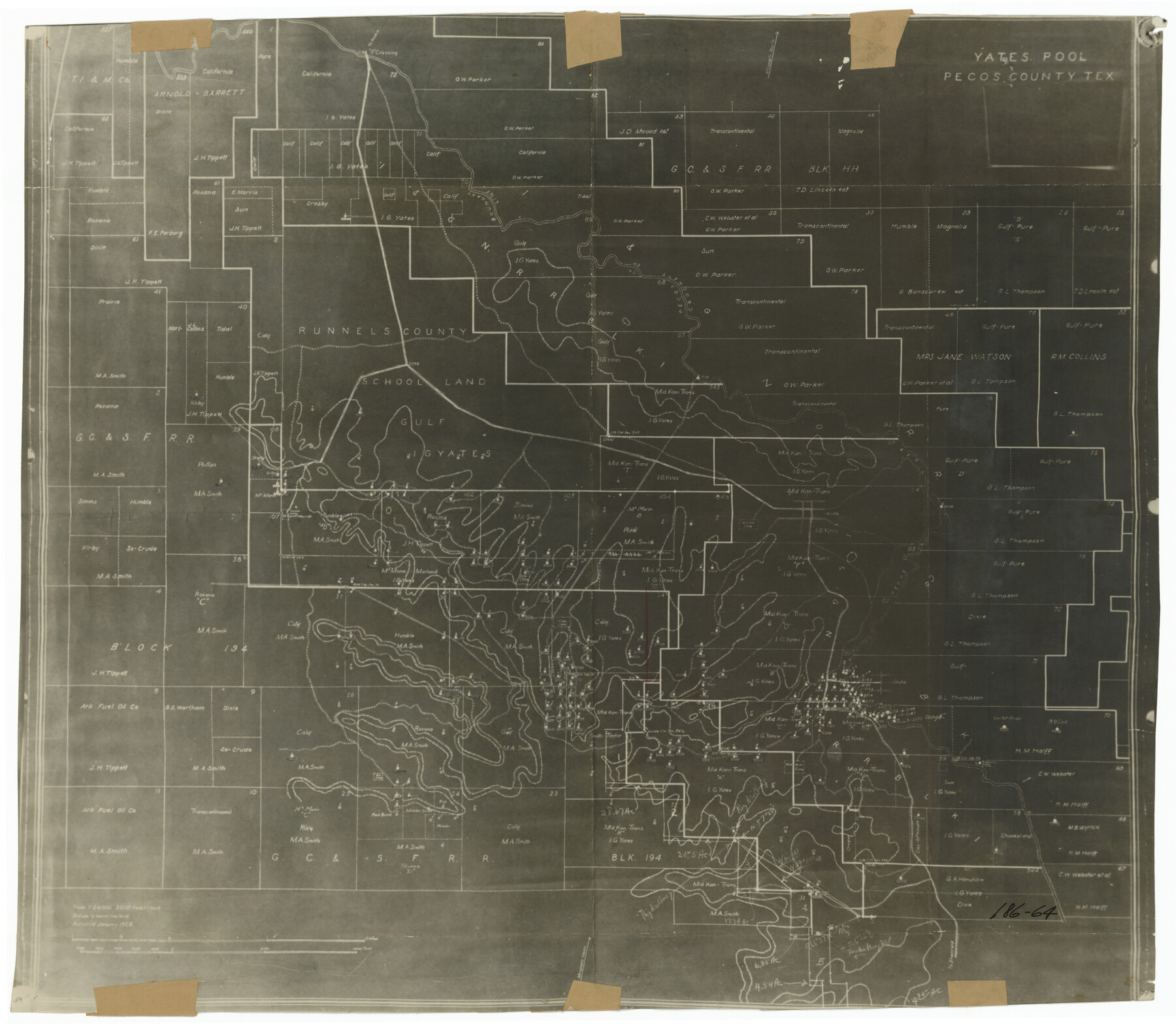
Yates Pool, Pecos County, Texas
186-64
-
Map/Doc
91623
-
Collection
Twichell Survey Records
-
Object Dates
1/1928 (Creation Date)
-
Counties
Pecos
-
Height x Width
21.3 x 18.3 inches
54.1 x 46.5 cm
Part of: Twichell Survey Records
[Sketch showing J.S. Brooks, W.B. Aldredge, Madison County School Land and Others]
![89730, [Sketch showing J.S. Brooks, W.B. Aldredge, Madison County School Land and Others], Twichell Survey Records](https://historictexasmaps.com/wmedia_w700/maps/89730-1.tif.jpg)
Print $20.00
- Digital $50.00
[Sketch showing J.S. Brooks, W.B. Aldredge, Madison County School Land and Others]
Size 37.1 x 39.9 inches
Map/Doc 89730
Working Sketch in Gaines and Dawson Counties

Print $20.00
- Digital $50.00
Working Sketch in Gaines and Dawson Counties
1939
Size 43.4 x 45.3 inches
Map/Doc 93254
A true copy of Peck's field book page 1, except classification of lands

Print $2.00
- Digital $50.00
A true copy of Peck's field book page 1, except classification of lands
1876
Size 5.3 x 12.0 inches
Map/Doc 91979
Ellwood Farms Situated in Hockley, Lamb, and Hale Counties, Texas

Print $20.00
- Digital $50.00
Ellwood Farms Situated in Hockley, Lamb, and Hale Counties, Texas
Size 20.3 x 30.1 inches
Map/Doc 92229
"G" Sketch from Gaines County

Print $20.00
- Digital $50.00
"G" Sketch from Gaines County
1902
Size 31.6 x 21.8 inches
Map/Doc 90845

[King, Knox & Stonewall Counties]
![92916, [King, Knox & Stonewall Counties], Twichell Survey Records](https://historictexasmaps.com/wmedia_w700/maps/92916-1.tif.jpg)
Print $20.00
- Digital $50.00
[King, Knox & Stonewall Counties]
1902
Size 19.6 x 28.1 inches
Map/Doc 92916
[Blocks 47, Z, XO2, M18, M23, M25, and H]
![91186, [Blocks 47, Z, XO2, M18, M23, M25, and H], Twichell Survey Records](https://historictexasmaps.com/wmedia_w700/maps/91186-1.tif.jpg)
Print $20.00
- Digital $50.00
[Blocks 47, Z, XO2, M18, M23, M25, and H]
Size 30.1 x 23.5 inches
Map/Doc 91186
Sketch in Crockett County, Texas

Print $20.00
- Digital $50.00
Sketch in Crockett County, Texas
1924
Size 34.4 x 47.8 inches
Map/Doc 92606
[H. & O. B. Blocks 1, B9, 24, J]
![90345, [H. & O. B. Blocks 1, B9, 24, J], Twichell Survey Records](https://historictexasmaps.com/wmedia_w700/maps/90345-1.tif.jpg)
Print $20.00
- Digital $50.00
[H. & O. B. Blocks 1, B9, 24, J]
Size 25.2 x 23.6 inches
Map/Doc 90345
Working Sketch in Randall and Swisher Cos.

Print $20.00
- Digital $50.00
Working Sketch in Randall and Swisher Cos.
1917
Size 14.6 x 36.3 inches
Map/Doc 93048
[Capitol Leagues 225-238]
![90677, [Capitol Leagues 225-238], Twichell Survey Records](https://historictexasmaps.com/wmedia_w700/maps/90677-1.tif.jpg)
Print $20.00
- Digital $50.00
[Capitol Leagues 225-238]
Size 23.2 x 13.0 inches
Map/Doc 90677
You may also like
Chambers County NRC Article 33.136 Sketch 12

Print $30.00
- Digital $50.00
Chambers County NRC Article 33.136 Sketch 12
2020
Size 24.0 x 35.9 inches
Map/Doc 96441
Flight Mission No. DCL-7C, Frame 77, Kenedy County

Print $20.00
- Digital $50.00
Flight Mission No. DCL-7C, Frame 77, Kenedy County
1943
Size 15.3 x 15.2 inches
Map/Doc 86063
Cass County Working Sketch 39

Print $20.00
- Digital $50.00
Cass County Working Sketch 39
1983
Size 26.3 x 34.6 inches
Map/Doc 67942
Fisher County Working Sketch 18

Print $20.00
- Digital $50.00
Fisher County Working Sketch 18
1941
Size 24.7 x 16.6 inches
Map/Doc 69152
Colorado County Working Sketch 2

Print $20.00
- Digital $50.00
Colorado County Working Sketch 2
1904
Size 28.8 x 30.1 inches
Map/Doc 68102
Flight Mission No. DAH-9M, Frame 202, Orange County

Print $20.00
- Digital $50.00
Flight Mission No. DAH-9M, Frame 202, Orange County
1953
Size 18.5 x 22.6 inches
Map/Doc 86870
Lipscomb County Boundary File 6

Print $4.00
- Digital $50.00
Lipscomb County Boundary File 6
Size 11.1 x 8.6 inches
Map/Doc 56329
Kent County Working Sketch 18

Print $20.00
- Digital $50.00
Kent County Working Sketch 18
1974
Size 33.5 x 31.5 inches
Map/Doc 70025
Freestone County Working Sketch 13

Print $40.00
- Digital $50.00
Freestone County Working Sketch 13
1980
Size 42.8 x 59.7 inches
Map/Doc 69255
Right of Way and Track Map, the Missouri, Kansas and Texas Ry. of Texas - Henrietta Division

Print $20.00
- Digital $50.00
Right of Way and Track Map, the Missouri, Kansas and Texas Ry. of Texas - Henrietta Division
1918
Size 11.8 x 26.9 inches
Map/Doc 64748
Zavala County Working Sketch 22

Print $40.00
- Digital $50.00
Zavala County Working Sketch 22
1980
Size 70.4 x 43.5 inches
Map/Doc 62097
San Jacinto County Rolled Sketch 12

Print $20.00
- Digital $50.00
San Jacinto County Rolled Sketch 12
1948
Size 24.2 x 32.5 inches
Map/Doc 7561