San Jacinto County Rolled Sketch 12
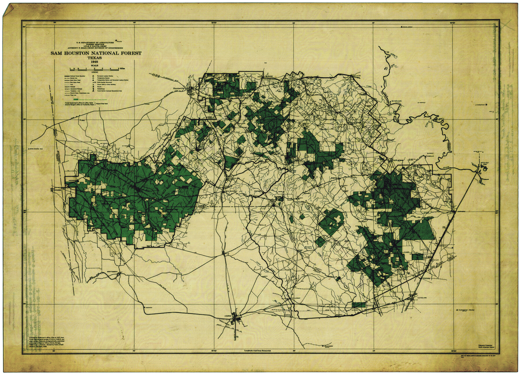
Sam Houston National Forest, Texas
-
Map/Doc
7561
-
Collection
General Map Collection
-
Object Dates
1948 (Creation Date)
2/13/1976 (File Date)
-
People and Organizations
U.S. Department of Agriculture, Forest Service (Publisher)
-
Counties
San Jacinto Montgomery Walker
-
Subjects
Surveying Rolled Sketch
-
Height x Width
24.2 x 32.5 inches
61.5 x 82.6 cm
-
Medium
paper, etching/engraving/lithograph
Part of: General Map Collection
[Sketch for Mineral Application 33721 - 33725 Incl. - Padre and Mustang Island]
![2870, [Sketch for Mineral Application 33721 - 33725 Incl. - Padre and Mustang Island], General Map Collection](https://historictexasmaps.com/wmedia_w700/maps/2870.tif.jpg)
Print $20.00
- Digital $50.00
[Sketch for Mineral Application 33721 - 33725 Incl. - Padre and Mustang Island]
1942
Size 22.1 x 22.4 inches
Map/Doc 2870
Fayette County Sketch File 5

Print $4.00
- Digital $50.00
Fayette County Sketch File 5
Size 14.3 x 8.7 inches
Map/Doc 22506
Reeves County Rolled Sketch 21

Print $20.00
- Digital $50.00
Reeves County Rolled Sketch 21
1978
Size 27.6 x 27.6 inches
Map/Doc 7489
Galveston County Sketch File 23

Print $4.00
- Digital $50.00
Galveston County Sketch File 23
Size 13.9 x 8.6 inches
Map/Doc 23394
Gillespie County Rolled Sketch 1

Print $20.00
- Digital $50.00
Gillespie County Rolled Sketch 1
1956
Size 19.7 x 36.1 inches
Map/Doc 6008
Houston County Rolled Sketch 11

Print $20.00
- Digital $50.00
Houston County Rolled Sketch 11
1988
Size 29.9 x 22.9 inches
Map/Doc 6231
Young County Sketch File 21

Print $20.00
- Digital $50.00
Young County Sketch File 21
1954
Size 19.0 x 23.0 inches
Map/Doc 12715
Duval County Rolled Sketch 39

Print $20.00
- Digital $50.00
Duval County Rolled Sketch 39
1956
Size 29.0 x 20.1 inches
Map/Doc 5756
Flight Mission No. CRC-2R, Frame 62, Chambers County

Print $20.00
- Digital $50.00
Flight Mission No. CRC-2R, Frame 62, Chambers County
1956
Size 18.6 x 22.5 inches
Map/Doc 84733
Flight Mission No. DQN-3K, Frame 69, Calhoun County

Print $20.00
- Digital $50.00
Flight Mission No. DQN-3K, Frame 69, Calhoun County
1953
Size 18.5 x 22.3 inches
Map/Doc 84360
Bexar County Working Sketch 12

Print $20.00
- Digital $50.00
Bexar County Working Sketch 12
1954
Size 24.7 x 21.0 inches
Map/Doc 67328
Val Verde County Working Sketch 115

Print $20.00
- Digital $50.00
Val Verde County Working Sketch 115
2002
Size 38.6 x 36.4 inches
Map/Doc 76400
You may also like
Williamson County Rolled Sketch 7

Print $40.00
- Digital $50.00
Williamson County Rolled Sketch 7
1924
Size 38.4 x 54.5 inches
Map/Doc 10146
Part of Laguna Madre in Nueces and Kleberg Counties, showing Subdivision for Mineral Development

Print $20.00
- Digital $50.00
Part of Laguna Madre in Nueces and Kleberg Counties, showing Subdivision for Mineral Development
1948
Size 36.9 x 26.6 inches
Map/Doc 1922
Flight Mission No. DAG-23K, Frame 60, Matagorda County

Print $20.00
- Digital $50.00
Flight Mission No. DAG-23K, Frame 60, Matagorda County
1953
Size 15.8 x 15.8 inches
Map/Doc 86487
Brewster County Rolled Sketch 126

Print $225.00
- Digital $50.00
Brewster County Rolled Sketch 126
1908
Map/Doc 43230
Duval County Sketch File 14

Print $2.00
- Digital $50.00
Duval County Sketch File 14
Size 10.3 x 8.5 inches
Map/Doc 21308
Wichita County Rolled Sketch 11

Print $20.00
- Digital $50.00
Wichita County Rolled Sketch 11
Size 20.8 x 18.6 inches
Map/Doc 8248
General Highway Map, Karnes County, Texas

Print $20.00
General Highway Map, Karnes County, Texas
1961
Size 18.1 x 24.6 inches
Map/Doc 79547
Flight Mission No. BRE-1P, Frame 94, Nueces County

Print $20.00
- Digital $50.00
Flight Mission No. BRE-1P, Frame 94, Nueces County
1956
Size 18.6 x 22.4 inches
Map/Doc 86665
Hardin County Working Sketch 34

Print $20.00
- Digital $50.00
Hardin County Working Sketch 34
1980
Size 15.7 x 12.1 inches
Map/Doc 63432
Montague County Working Sketch 20

Print $20.00
- Digital $50.00
Montague County Working Sketch 20
1952
Size 23.0 x 37.0 inches
Map/Doc 71086
Map of Roberts County

Print $20.00
- Digital $50.00
Map of Roberts County
1932
Size 42.9 x 39.0 inches
Map/Doc 95626
Missouri, Kansas, and Texas Railway

Print $20.00
Missouri, Kansas, and Texas Railway
1878
Size 16.5 x 12.2 inches
Map/Doc 76188