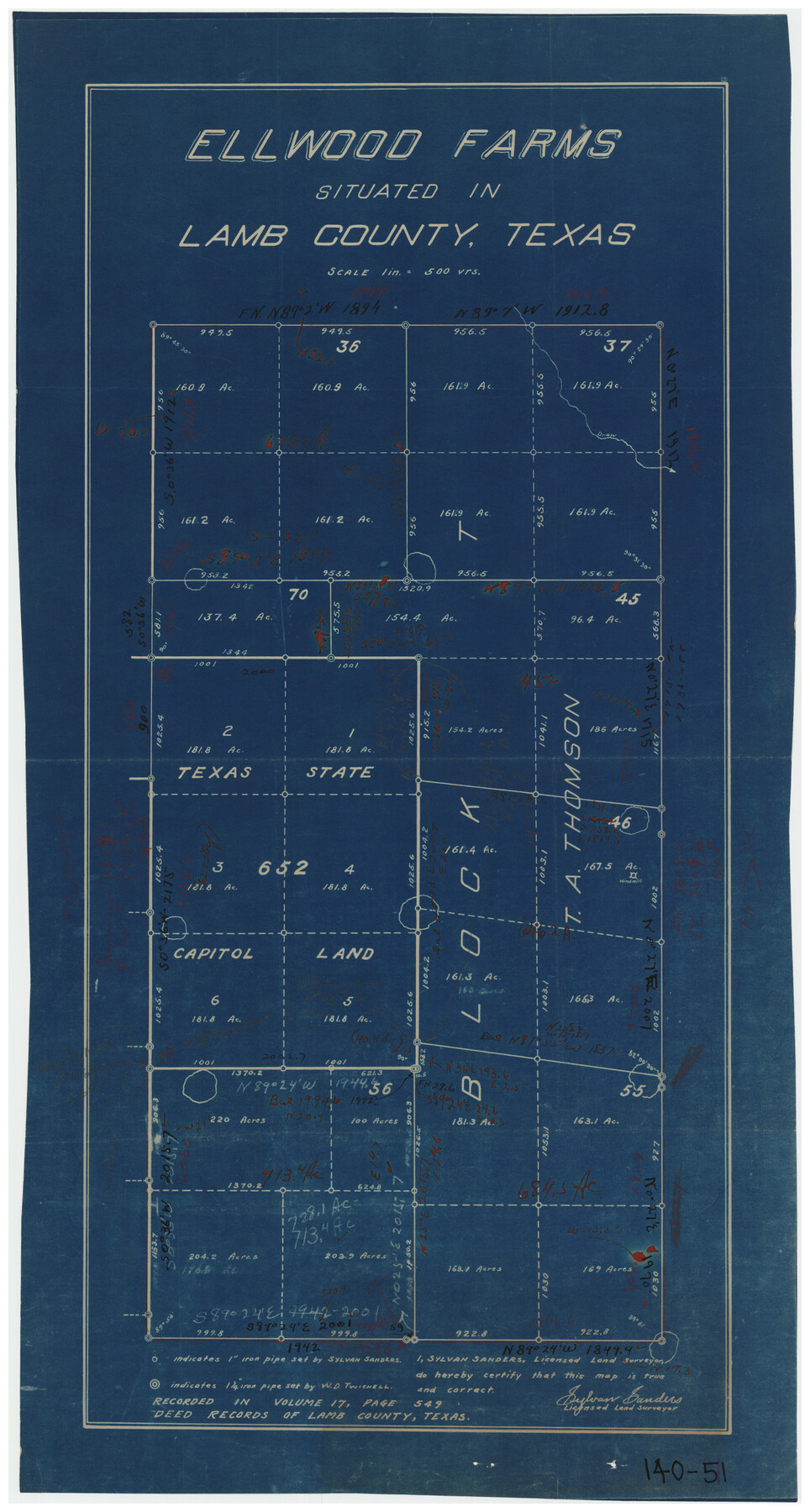
Ellwood Farms, Situated in Lamb County, Texas
140-51
-
Map/Doc
90994
-
Collection
Twichell Survey Records
-
People and Organizations
Sylvan Sanders (Surveyor/Engineer)
-
Counties
Lamb
-
Height x Width
12.7 x 23.1 inches
32.3 x 58.7 cm
Part of: Twichell Survey Records

[Blocks D3 and GP]
![91506, [Blocks D3 and GP], Twichell Survey Records](https://historictexasmaps.com/wmedia_w700/maps/91506-1.tif.jpg)
Print $20.00
- Digital $50.00
[Blocks D3 and GP]
Size 18.2 x 19.3 inches
Map/Doc 91506
[E. T. Ry. Blk. 1]
![89795, [E. T. Ry. Blk. 1], Twichell Survey Records](https://historictexasmaps.com/wmedia_w700/maps/89795-1.tif.jpg)
Print $40.00
- Digital $50.00
[E. T. Ry. Blk. 1]
Size 40.6 x 51.2 inches
Map/Doc 89795

L Sketch from Ward and Crane Co's

Print $20.00
- Digital $50.00
L Sketch from Ward and Crane Co's
Size 39.6 x 23.2 inches
Map/Doc 90462
[Connecting lines from west corner of S. K. & K. Block M6 to northwest corner section 1, J. G. & S. M. Blk. 2Z]
![90399, [Connecting lines from west corner of S. K. & K. Block M6 to northwest corner section 1, J. G. & S. M. Blk. 2Z], Twichell Survey Records](https://historictexasmaps.com/wmedia_w700/maps/90399-1.tif.jpg)
Print $20.00
- Digital $50.00
[Connecting lines from west corner of S. K. & K. Block M6 to northwest corner section 1, J. G. & S. M. Blk. 2Z]
Size 25.1 x 17.0 inches
Map/Doc 90399
Sketch in Cochran County, Texas

Print $20.00
- Digital $50.00
Sketch in Cochran County, Texas
1949
Size 21.8 x 21.0 inches
Map/Doc 92495
[Blocks C22, C23, C24, 77, B3, B5, 26, 27, 74, 75]
![91973, [Blocks C22, C23, C24, 77, B3, B5, 26, 27, 74, 75], Twichell Survey Records](https://historictexasmaps.com/wmedia_w700/maps/91973-1.tif.jpg)
Print $20.00
- Digital $50.00
[Blocks C22, C23, C24, 77, B3, B5, 26, 27, 74, 75]
Size 21.9 x 16.9 inches
Map/Doc 91973
[Nathaniel H. Cochran Survey and Vicinity]
![91497, [Nathaniel H. Cochran Survey and Vicinity], Twichell Survey Records](https://historictexasmaps.com/wmedia_w700/maps/91497-1.tif.jpg)
Print $20.00
- Digital $50.00
[Nathaniel H. Cochran Survey and Vicinity]
Size 25.5 x 18.8 inches
Map/Doc 91497
[North Part of T. A. Thomson, Block T]
![91075, [North Part of T. A. Thomson, Block T], Twichell Survey Records](https://historictexasmaps.com/wmedia_w700/maps/91075-1.tif.jpg)
Print $20.00
- Digital $50.00
[North Part of T. A. Thomson, Block T]
Size 17.6 x 14.3 inches
Map/Doc 91075
[Part of Block D7]
![91944, [Part of Block D7], Twichell Survey Records](https://historictexasmaps.com/wmedia_w700/maps/91944-1.tif.jpg)
Print $20.00
- Digital $50.00
[Part of Block D7]
Size 36.5 x 18.8 inches
Map/Doc 91944
[Leagues 656-666, 671-676, 684-688, 692-695]
![91007, [Leagues 656-666, 671-676, 684-688, 692-695], Twichell Survey Records](https://historictexasmaps.com/wmedia_w700/maps/91007-1.tif.jpg)
Print $20.00
- Digital $50.00
[Leagues 656-666, 671-676, 684-688, 692-695]
Size 30.6 x 20.7 inches
Map/Doc 91007
You may also like
Sabine River, Toll Bridge Sheet

Print $40.00
- Digital $50.00
Sabine River, Toll Bridge Sheet
1933
Size 27.8 x 51.9 inches
Map/Doc 65136
Hutchinson County Rolled Sketch 40

Print $20.00
- Digital $50.00
Hutchinson County Rolled Sketch 40
1981
Size 26.8 x 37.6 inches
Map/Doc 6301
Flight Mission No. BRA-7M, Frame 180, Jefferson County

Print $20.00
- Digital $50.00
Flight Mission No. BRA-7M, Frame 180, Jefferson County
1953
Size 18.7 x 22.4 inches
Map/Doc 85548
[W. T. Brewer: M. McDonald, Ralph Gilpin, A. Vanhooser, John Baker, John R. Taylor Surveys]
![90964, [W. T. Brewer: M. McDonald, Ralph Gilpin, A. Vanhooser, John Baker, John R. Taylor Surveys], Twichell Survey Records](https://historictexasmaps.com/wmedia_w700/maps/90964-1.tif.jpg)
Print $2.00
- Digital $50.00
[W. T. Brewer: M. McDonald, Ralph Gilpin, A. Vanhooser, John Baker, John R. Taylor Surveys]
Size 8.8 x 11.3 inches
Map/Doc 90964
Jeff Davis County Working Sketch 20

Print $40.00
- Digital $50.00
Jeff Davis County Working Sketch 20
1957
Size 63.0 x 32.8 inches
Map/Doc 66515
[Map of Texas and Pacific Blocks from Brazos River westward through Palo Pinto, Stephens, Shackelford, Jones, Callahan, Taylor, Fisher, Nolan and Mitchell Counties]
![93456, [Map of Texas and Pacific Blocks from Brazos River westward through Palo Pinto, Stephens, Shackelford, Jones, Callahan, Taylor, Fisher, Nolan and Mitchell Counties], General Map Collection](https://historictexasmaps.com/wmedia_w700/maps/93456-1.tif.jpg)
Print $20.00
- Digital $50.00
[Map of Texas and Pacific Blocks from Brazos River westward through Palo Pinto, Stephens, Shackelford, Jones, Callahan, Taylor, Fisher, Nolan and Mitchell Counties]
Size 22.0 x 18.5 inches
Map/Doc 93456
Tom Green County Rolled Sketch 20

Print $20.00
- Digital $50.00
Tom Green County Rolled Sketch 20
Size 20.7 x 13.3 inches
Map/Doc 8003

Leon County Working Sketch 23

Print $20.00
- Digital $50.00
Leon County Working Sketch 23
1965
Size 14.2 x 29.7 inches
Map/Doc 70422
Aransas County Sketch File 15b

Print $10.00
- Digital $50.00
Aransas County Sketch File 15b
1891
Size 13.8 x 8.1 inches
Map/Doc 13143
Lamb County Working Sketch 2

Print $20.00
- Digital $50.00
Lamb County Working Sketch 2
1919
Size 13.6 x 15.3 inches
Map/Doc 70275
Hutchinson County Working Sketch 13

Print $20.00
- Digital $50.00
Hutchinson County Working Sketch 13
1926
Size 22.6 x 31.5 inches
Map/Doc 66371