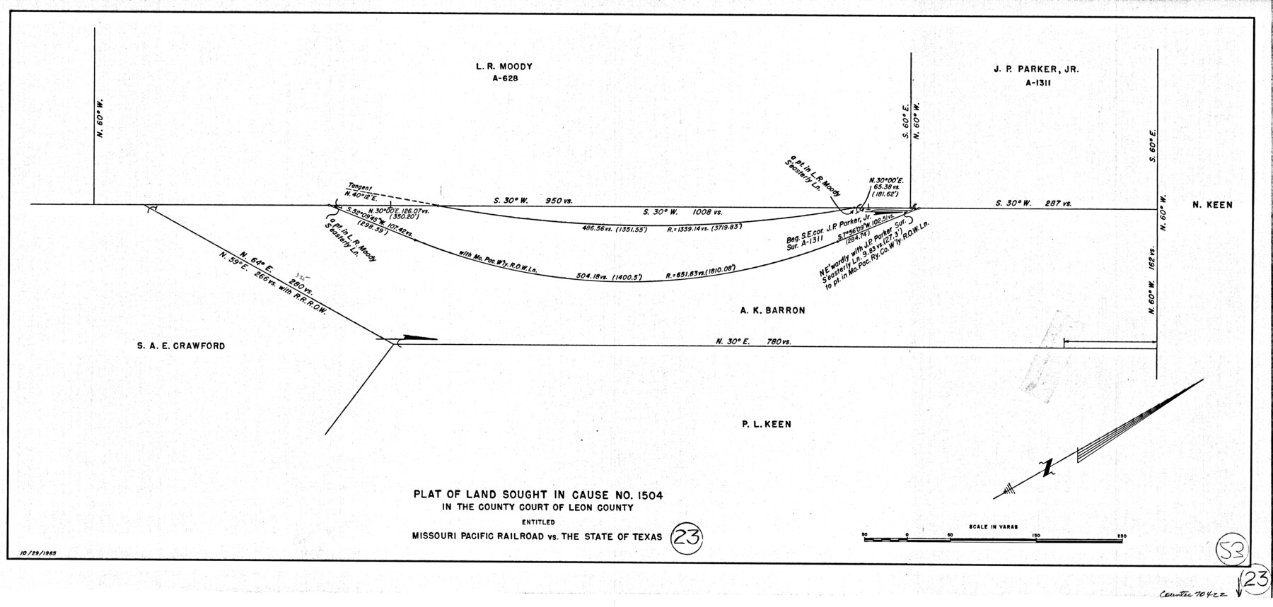
Leon County Working Sketch 23
Plat of land sought in Cause No. 1504 in the County Court of Leon County entitled Missouri Pacific Railroad vs. The State of Texas
-
Map/Doc
70422
-
Collection
General Map Collection
-
Object Dates
10/29/1965 (Creation Date)
-
Counties
Leon
-
Subjects
Surveying Working Sketch
-
Height x Width
14.2 x 29.7 inches
36.1 x 75.4 cm
Part of: General Map Collection
Kleberg County Boundary File 2a

Print $40.00
- Digital $50.00
Kleberg County Boundary File 2a
Size 15.4 x 58.3 inches
Map/Doc 64977
Sabine County Rolled Sketch 2

Print $20.00
- Digital $50.00
Sabine County Rolled Sketch 2
1949
Size 33.3 x 20.8 inches
Map/Doc 7551
Texas Intracoastal Waterway - Laguna Madre - Dagger Hill to Potrero Grande

Print $20.00
- Digital $50.00
Texas Intracoastal Waterway - Laguna Madre - Dagger Hill to Potrero Grande
1960
Size 38.3 x 27.0 inches
Map/Doc 73511
Floyd County Working Sketch 3

Print $20.00
- Digital $50.00
Floyd County Working Sketch 3
1948
Size 27.4 x 22.8 inches
Map/Doc 69182
Terrell County Working Sketch 70

Print $20.00
- Digital $50.00
Terrell County Working Sketch 70
1979
Size 39.0 x 36.5 inches
Map/Doc 69591
Upshur County Working Sketch 16, revised

Print $20.00
- Digital $50.00
Upshur County Working Sketch 16, revised
1997
Size 42.9 x 37.2 inches
Map/Doc 69574
Railroad Track Map, H&TCRRCo., Falls County, Texas

Print $4.00
- Digital $50.00
Railroad Track Map, H&TCRRCo., Falls County, Texas
1918
Size 11.8 x 18.5 inches
Map/Doc 62837
Bosque County Working Sketch 22

Print $40.00
- Digital $50.00
Bosque County Working Sketch 22
1984
Size 38.2 x 54.9 inches
Map/Doc 67455
San Jacinto County Sketch File 5

Print $2.00
San Jacinto County Sketch File 5
1848
Size 8.1 x 14.5 inches
Map/Doc 35702
Flight Mission No. BRA-16M, Frame 164, Jefferson County

Print $20.00
- Digital $50.00
Flight Mission No. BRA-16M, Frame 164, Jefferson County
1953
Size 18.7 x 22.3 inches
Map/Doc 85762
Lipscomb County Rolled Sketch 5

Print $40.00
- Digital $50.00
Lipscomb County Rolled Sketch 5
Size 61.8 x 8.1 inches
Map/Doc 10640
Real County Working Sketch 50

Print $20.00
- Digital $50.00
Real County Working Sketch 50
1957
Size 19.8 x 26.1 inches
Map/Doc 71942
You may also like
Aransas County Working Sketch 26

Print $20.00
- Digital $50.00
Aransas County Working Sketch 26
1965
Size 40.8 x 29.4 inches
Map/Doc 67193
Borden and Garza County Boundary Line Plat

Print $2.00
- Digital $50.00
Borden and Garza County Boundary Line Plat
1965
Size 14.2 x 8.8 inches
Map/Doc 61152
![[San Benito Promotional Booklet]](https://historictexasmaps.com/wmedia_w700/pdf_converted_jpg/qi_pdf_thumbnail_64211.jpg)

Flight Mission No. DQN-2K, Frame 127, Calhoun County

Print $20.00
- Digital $50.00
Flight Mission No. DQN-2K, Frame 127, Calhoun County
1953
Size 18.4 x 22.3 inches
Map/Doc 84301
Hudspeth County Sketch File 20

Print $40.00
- Digital $50.00
Hudspeth County Sketch File 20
Size 37.1 x 57.3 inches
Map/Doc 10494
Liberty County Working Sketch 42

Print $20.00
- Digital $50.00
Liberty County Working Sketch 42
1953
Size 24.0 x 35.8 inches
Map/Doc 70501
Runnels County Sketch File 34

Print $20.00
Runnels County Sketch File 34
1889
Size 16.6 x 26.7 inches
Map/Doc 12265
Flight Mission No. DAG-28K, Frame 24, Matagorda County

Print $20.00
- Digital $50.00
Flight Mission No. DAG-28K, Frame 24, Matagorda County
1953
Size 16.2 x 16.0 inches
Map/Doc 86592
Zappe Land Company's Subdivision of Chas. Butler Lands

Print $20.00
- Digital $50.00
Zappe Land Company's Subdivision of Chas. Butler Lands
Size 20.4 x 16.5 inches
Map/Doc 92735
Flight Mission No. CRC-4R, Frame 97, Chambers County

Print $20.00
- Digital $50.00
Flight Mission No. CRC-4R, Frame 97, Chambers County
1956
Size 18.6 x 22.2 inches
Map/Doc 84894
Dawson County Rolled Sketch 4

Print $20.00
- Digital $50.00
Dawson County Rolled Sketch 4
Size 24.3 x 23.9 inches
Map/Doc 5690